Chesterfield, Indiana facts for kids
Quick facts for kids
Chesterfield, Indiana
|
|
|---|---|

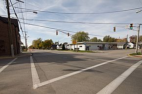
Intersection of Main Street and Washington Street
|
|
| Motto(s):
"A Progressive Community"
|
|

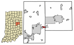
Location in Madison and Delaware counties, Indiana
|
|
| Country | United States |
| State | Indiana |
| Counties | Madison, Delaware |
| Townships | Union, Salem |
| Area | |
| • Total | 1.37 sq mi (3.54 km2) |
| • Land | 1.37 sq mi (3.54 km2) |
| • Water | 0.00 sq mi (0.00 km2) |
| Elevation | 899 ft (274 m) |
| Population
(2020)
|
|
| • Total | 2,490 |
| • Density | 1,818.85/sq mi (702.51/km2) |
| Time zone | UTC−5 (EST) |
| • Summer (DST) | UTC−5 (EST) |
| ZIP Code |
46017
|
| Area code(s) | 765 |
| FIPS code | 18-12376 |
| GNIS feature ID | 2396641 |
Chesterfield is a town in the U.S. state of Indiana. It is located in both Madison County and Delaware County. In 2020, about 2,490 people lived here. Chesterfield is part of the larger Indianapolis–Carmel–Anderson metropolitan area.
Contents
History of Chesterfield
Chesterfield was first known as "West Union." Its name was changed to Chesterfield in 1834.
Two important places in Chesterfield are listed on the National Register of Historic Places. These are the Chesterfield Spiritualist Camp District and the George Makepeace House. Being on this list means they are special and historically important.
Where is Chesterfield?
Chesterfield is in eastern Madison County. A small part of the town also reaches into southwestern Delaware County. To the west, it borders the city of Anderson. To the east, it is next to the town of Daleville.
Roads and Rivers
Indiana State Road 32 goes through Chesterfield. It is known as Main Street in town. This road leads west to Anderson and northeast to Muncie, which is about 13 miles away.
Interstate 69 is just east of Chesterfield. You can get on I-69 from Exit 234 (SR 67). I-69 goes southwest to Indianapolis (about 44 miles) and north to Fort Wayne (about 76 miles). The White River flows along the northern edge of the town.
Chesterfield covers a total area of about 1.37 square miles. All of this area is land.
People of Chesterfield
| Historical population | |||
|---|---|---|---|
| Census | Pop. | %± | |
| 1870 | 203 | — | |
| 1880 | 150 | −26.1% | |
| 1910 | 285 | — | |
| 1920 | 319 | 11.9% | |
| 1930 | 460 | 44.2% | |
| 1940 | 581 | 26.3% | |
| 1950 | 1,086 | 86.9% | |
| 1960 | 2,588 | 138.3% | |
| 1970 | 3,001 | 16.0% | |
| 1980 | 2,701 | −10.0% | |
| 1990 | 2,730 | 1.1% | |
| 2000 | 2,969 | 8.8% | |
| 2010 | 2,547 | −14.2% | |
| 2020 | 2,490 | −2.2% | |
| 2022 (est.) | 2,498 | −1.9% | |
| U.S. Decennial Census | |||
Chesterfield's Population in 2020
In 2020, there were 2,490 people living in Chesterfield. There were 1,098 households. Most residents, about 91.2%, were White. About 1.2% were African American, and 0.6% were Asian. Some residents were from other races or a mix of two or more races. About 2.6% of the population was Hispanic or Latino.
About 21.0% of households had children under 18 living with them. The average household had 2.27 people. The average family had 3.06 people.
The average age in Chesterfield was 41.6 years old. About 21.0% of residents were under 18. Also, 21.0% of residents were 65 years old or older.
Most people in Chesterfield speak English at home (97.3%). A smaller number speak Spanish (2.5%).
Chesterfield's Population in 2010
In 2010, Chesterfield had 2,547 people. There were 1,090 households. About 97.4% of the people were White. A small number were African American, Native American, or Asian. About 1.1% of the population was Hispanic or Latino.
About 31.5% of households had children under 18. The average household size was 2.28 people. The average family size was 2.89 people.
The average age in 2010 was 39.5 years. About 22.8% of residents were under 18. About 17.3% were 65 years old or older.
Getting Around Chesterfield
Chesterfield has several major roads that help people travel.
See also
 In Spanish: Chesterfield (Indiana) para niños
 | Georgia Louise Harris Brown |
 | Julian Abele |
 | Norma Merrick Sklarek |
 | William Sidney Pittman |


