Selma, Indiana facts for kids
Quick facts for kids
Selma, Indiana
|
|
|---|---|

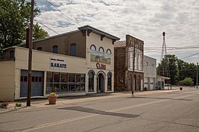
Main street
|
|

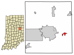
Location of Selma in Delaware County, Indiana.
|
|
| Country | United States |
| State | Indiana |
| County | Delaware |
| Township | Liberty |
| Area | |
| • Total | 0.90 sq mi (2.33 km2) |
| • Land | 0.90 sq mi (2.32 km2) |
| • Water | 0.00 sq mi (0.01 km2) |
| Elevation | 1,004 ft (306 m) |
| Population
(2020)
|
|
| • Total | 747 |
| • Density | 834.64/sq mi (322.17/km2) |
| Time zone | UTC-5 (Eastern (EST)) |
| • Summer (DST) | UTC-4 (EDT) |
| ZIP code |
47383
|
| Area code(s) | 765 |
| FIPS code | 18-68706 |
| GNIS feature ID | 2397650 |
Selma is a small town located in Delaware County, Indiana, United States. It is part of Liberty Township. In 2020, about 747 people lived there. Selma is also part of the larger Muncie, IN area.
Contents
History of Selma
Selma was officially planned and marked out in 1852. This happened when the railroad tracks were built to reach that spot. The town got its own post office the very next year, in 1853.
Gas and Oil Boom
In the late 1800s and early 1900s, Selma was greatly affected by the Indiana Gas Boom. During this time, natural gas and oil were discovered in Indiana. These discoveries became the main industries in Selma. The town officially became an incorporated town in 1907.
Recent Events: 2024 Tornado
On March 14, 2024, a strong tornado hit Selma. This tornado was rated as an EF2. It mainly affected the northern parts of the town.
Geography of Selma
Selma is located in Indiana. Indiana State Road 32 runs along the northern edge of the town.
Area and Size
According to information from 2010, Selma covers a total area of about 0.912 square miles (2.36 square kilometers). Most of this area, about 0.91 square miles (2.35 square kilometers), is land. Only a very small part, about 0.002 square miles (0.005 square kilometers), is water.
People of Selma: Demographics
| Historical population | |||
|---|---|---|---|
| Census | Pop. | %± | |
| 1880 | 244 | — | |
| 1910 | 350 | — | |
| 1920 | 318 | −9.1% | |
| 1930 | 344 | 8.2% | |
| 1940 | 424 | 23.3% | |
| 1950 | 499 | 17.7% | |
| 1960 | 562 | 12.6% | |
| 1970 | 890 | 58.4% | |
| 1980 | 1,056 | 18.7% | |
| 1990 | 800 | −24.2% | |
| 2000 | 880 | 10.0% | |
| 2010 | 866 | −1.6% | |
| 2020 | 747 | −13.7% | |
| 2022 (est.) | 743 | −14.2% | |
| U.S. Decennial Census | |||
Selma's Population in 2020
The census in 2020 counted 747 people living in Selma. There were 313 households in the town. The town had about 830 people per square mile.
Most of the people living in Selma were White, making up about 93.3% of the population. A small number of residents were African American, Native American, Asian, or Pacific Islander. About 5.2% of the population identified as being from two or more races. About 1.9% of the population was Hispanic or Latino.
The most common language spoken at home in Selma was English. About 99.1% of residents spoke English at home.
Notable People from Selma
- Jeremy Hazelbaker, a professional baseball player, is from Selma.
See also
 In Spanish: Selma (Indiana) para niños
 | Tommie Smith |
 | Simone Manuel |
 | Shani Davis |
 | Simone Biles |
 | Alice Coachman |

