Smockville, Indiana facts for kids
Quick facts for kids
Smockville, Indiana
|
|
|---|---|

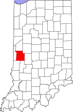
Parke County's location in Indiana
|
|
| Country | United States |
| State | Indiana |
| County | Parke |
| Township | Raccoon |
| Elevation | 656 ft (200 m) |
| Time zone | UTC-5 (Eastern (EST)) |
| • Summer (DST) | UTC-4 (EDT) |
| ZIP code |
47837
|
| Area code(s) | 765 |
| GNIS feature ID | 443711 |
Smockville is a small, unincorporated community located in Parke County, in the state of Indiana, United States. An unincorporated community means it's a group of homes and businesses that isn't officially a town or city with its own local government. Instead, it's part of a larger area called a township.
History of Smockville
Smockville began its life as a coal town. This means the community grew up around the business of mining coal. In the past, coal was a very important source of energy. It was used to power factories, heat homes, and even run trains.
Life in a Coal Town
People moved to places like Smockville to work in the coal mines. These towns often had houses for the miners and their families. They also had stores and other services needed by the mining community. The success of the town depended heavily on the coal industry.
Geography of Smockville
Smockville is found at specific coordinates: 39 degrees, 37 minutes, 34 seconds North and 87 degrees, 7 minutes, 59 seconds West. This location is in Raccoon Township. The community sits at an elevation of 659 feet (about 200 meters) above sea level. Elevation tells us how high a place is compared to the ocean.
 | Delilah Pierce |
 | Gordon Parks |
 | Augusta Savage |
 | Charles Ethan Porter |


