Linnsburg, Indiana facts for kids
Quick facts for kids
Linnsburg, Indiana
|
|
|---|---|
 |
|
| Country | United States |
| State | Indiana |
| County | Montgomery |
| Township | Walnut |
| Area | |
| • Total | 0.38 sq mi (1.0 km2) |
| • Land | 0.38 sq mi (1.0 km2) |
| • Water | 0.0 sq mi (0 km2) |
| Elevation | 843 ft (257 m) |
| Time zone | UTC-5 (Eastern (EST)) |
| • Summer (DST) | UTC-4 (EDT) |
| ZIP code |
47933 (Crawfordsville
|
| Area code(s) | 765 |
| GNIS feature ID | 2830468 |
| FIPS code | 18-44172 |
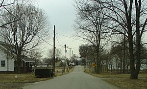
Linnsburg is a small community in Indiana, United States. It is called a census-designated place (CDP). This means it's an area that the government counts for population, even though it's not an officially incorporated town or city. Linnsburg is located in Walnut Township, within Montgomery County.
Linnsburg used to be a "whistle stop" on the Monon branch train line. A whistle stop was a place where trains would stop only if someone signaled them or if passengers wanted to get off. Today, trains still use these tracks for active rail service.
Contents
History of Linnsburg
Linnsburg was officially planned and laid out in 1870 by a person named Susan McMullen. When a place is "platted," it means its streets, blocks, and lots are drawn on a map.
Early Services and Communication
A post office was opened in Linnsburg in 1887. This office helped people send and receive letters and packages. The post office served the community for many years until it closed in 1934.
The 1995 Tornado Event
In the early morning of May 13, 1995, a powerful tornado hit Linnsburg. This tornado was rated as an F-2 on the Fujita scale, which measures how strong tornadoes are. It was a very serious storm that caused great sadness in the community.
The tornado damaged parts of a steel company called Nucor Steel. It also harmed Walnut Township Elementary School and several homes and farms in the area. Police officers and firefighters from all over Montgomery County quickly came to help. They spent many hours searching through the damaged areas for anyone who needed help. This tornado was part of a larger series of storms that affected the Midwest region.
Geography of Linnsburg
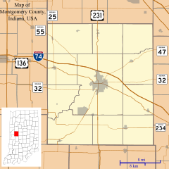
Linnsburg is located in the eastern part of Montgomery County. It is situated just south of another community called Mace. The community is about 6 miles (10 km) southeast of Crawfordsville. Crawfordsville is the main town and "county seat" for Montgomery County, which means it's where the county government offices are located. Linnsburg is also about 39 miles (63 km) northwest of downtown Indianapolis, a much larger city.
Land Area
According to the U.S. Census Bureau, the Linnsburg CDP covers an area of 0.38 square miles (0.98 square kilometers). All of this area is land, meaning there are no large bodies of water like lakes or rivers within the CDP boundaries.
 | Toni Morrison |
 | Barack Obama |
 | Martin Luther King Jr. |
 | Ralph Bunche |


