
Mace, Indiana facts for kids
Quick facts for kids
Mace, Indiana
|
|
|---|---|

Corner of Main Street and 600 East on the east side of Mace
|
|

Mace, Indiana
Location in Montgomery County, Indiana
|
|
| Country | United States |
| State | Indiana |
| County | Montgomery |
| Township | Walnut |
| Area | |
| • Total | 0.23 sq mi (0.6 km2) |
| • Land | 0.23 sq mi (0.6 km2) |
| • Water | 0.0 sq mi (0 km2) |
| Elevation | 837 ft (255 m) |
| Time zone | UTC-5 (Eastern (EST)) |
| • Summer (DST) | UTC-4 (EDT) |
| ZIP code |
47933 (Crawfordsville
|
| Area code(s) | 765 |
| FIPS code | 18-45720 |
| GNIS feature ID | 2830469 |
Mace is a small community located in Walnut Township, Montgomery County, in the state of Indiana, United States. It is known as an unincorporated community, which means it doesn't have its own local government like a city or town. It's also a census-designated place (CDP), which means the U.S. Census Bureau counts it as a specific area for population statistics.
History of Mace
Mace was once called "Fredericksburg." It was first planned out around the year 1840 by a person named Frederick Long.
A post office was opened in Mace in 1853. This post office helped people send and receive mail for many years. However, it eventually closed down in 1912.
Geography of Mace
Mace is located in the eastern part of Montgomery County. To its south, you'll find the community of Linnsburg.
A major road, U.S. Route 136, goes right through Mace. If you travel northwest on this road for about 6 miles (10 km), you will reach Crawfordsville. Crawfordsville is the main town and county seat of Montgomery County. If you go southeast on U.S. Route 136 for about 10 miles (16 km), you will arrive at Jamestown. The large city of Indianapolis is about 39 miles (63 km) southeast of Mace.
Mace is a small area, covering about 0.23 square miles (0.60 km²) of land. Water from Mace flows north into a small stream. This stream eventually joins the Walnut Fork of Sugar Creek, which then flows into Sugar Creek near Crawfordsville. All these waterways are part of the larger Wabash River system.
Images for kids
-
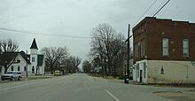
Looking east along U.S. Route 136 into Mace
-
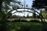
Mace Cemetery


