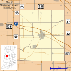
Elmdale, Indiana facts for kids
Quick facts for kids
Elmdale, Indiana
|
|
|---|---|
The corner of Old 55 and County Road 600 West.
|
|
| Country | United States |
| State | Indiana |
| County | Montgomery |
| Township | Coal Creek |
| Elevation | 827 ft (252 m) |
| Time zone | UTC-5 (Eastern (EST)) |
| • Summer (DST) | UTC-4 (EDT) |
| ZIP code |
47933
|
| Area code(s) | 765 |
| FIPS code | 18-20890 |
| GNIS feature ID | 434127 |
Elmdale is a small, quiet community located in Montgomery County, Indiana, in the United States. It's known as an "unincorporated community," which means it's a group of homes and businesses that isn't officially a town or city with its own local government. Instead, it's part of a larger area called Coal Creek Township.
A Look Back in Time
How Elmdale Got Its Name
Elmdale wasn't always called Elmdale! When it first started, this community was known as Boston Store. The name was later changed to Elmdale. People believe this new name came from the many elm trees that grew in the area. Imagine a place filled with tall, leafy elm trees – that's likely how Elmdale got its name!
The Post Office Story
A post office is a place where you can send and receive mail. For a long time, Elmdale had its own post office. It first opened in 1866 under the name Boston Store. Then, in 1882, when the community's name changed, the post office also changed its name to Elmdale. This post office served the community for many years until it closed down in 1905.
 | Sharif Bey |
 | Hale Woodruff |
 | Richmond Barthé |
 | Purvis Young |


