Whitesville, Indiana facts for kids
Quick facts for kids
Whitesville, Indiana
|
|
|---|---|
| Country | United States |
| State | Indiana |
| County | Montgomery |
| Township | Union |
| Elevation | 873 ft (266 m) |
| Time zone | UTC-5 (Eastern (EST)) |
| • Summer (DST) | UTC-4 (EDT) |
| ZIP code |
47968
|
| Area code(s) | 765 |
| FIPS code | 18-84032 |
| GNIS feature ID | 445979 |
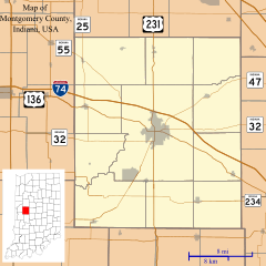
Whitesville is a small place in Montgomery County, Indiana, in the United States. It is known as an "unincorporated community."
What is Whitesville?
Whitesville is an unincorporated community. This means it is a group of homes and businesses that is not officially a city or town. It does not have its own local government. Instead, it is part of a larger area called a township. Whitesville is located in Union Township.
Where is Whitesville?
Whitesville is found in the state of Indiana. It is in the central part of the state. The area is about 873 feet (266 meters) above sea level. This means it is higher than many other places.
History of Whitesville
Whitesville has a bit of history tied to how people communicated long ago.
- A post office was opened in Whitesville in 1852.
- A post office was a place where people could send and receive letters and packages.
- Joseph S. White was one of the first people in charge of the post office. He was called the postmaster.
- The post office stayed open for many years. It closed down in 1919.
Black History Month on Kiddle
Famous African-American Artists:
 | Delilah Pierce |
 | Gordon Parks |
 | Augusta Savage |
 | Charles Ethan Porter |

All content from Kiddle encyclopedia articles (including the article images and facts) can be freely used under Attribution-ShareAlike license, unless stated otherwise. Cite this article:
Whitesville, Indiana Facts for Kids. Kiddle Encyclopedia.

