
Wingate, Indiana facts for kids
Quick facts for kids
Wingate, Indiana
|
|
|---|---|
 |
|

Location in Montgomery County, Indiana
|
|
| Country | United States |
| State | Indiana |
| County | Montgomery |
| Township | Coal Creek |
| Area | |
| • Total | 0.19 sq mi (0.50 km2) |
| • Land | 0.19 sq mi (0.50 km2) |
| • Water | 0.00 sq mi (0.00 km2) |
| Elevation | 774 ft (236 m) |
| Population
(2020)
|
|
| • Total | 237 |
| • Density | 1,221.65/sq mi (472.83/km2) |
| Time zone | UTC-5 (Eastern (EST)) |
| • Summer (DST) | UTC-4 (EDT) |
| ZIP code |
47994
|
| Area code(s) | 765 |
| FIPS code | 18-84914 |
| GNIS feature ID | 2397750 |

Wingate is a small town located in Montgomery County, Indiana. It was once known as "Pleasant Hill." In 2020, about 237 people lived there.
Contents
A Look at Wingate's Past
Wingate was first planned out and named "Pleasant Hill" in 1832 by a person named Christian Bever. Planning a town means drawing out its streets and lots.
Later, in the late 1800s and early 1900s, the town's name changed a few times. It was briefly called "Whitlock" on maps. The name "Pleasant Hill" was changed to avoid confusion with another town that had the same name along the train tracks. The name "Whitlock" was used for a short time because of disagreements with John C. Wingate, a well-known person in the town. Eventually, the town was named "Wingate" to honor him.
Wingate's Sports History
Wingate has a proud history in sports, especially basketball! Signs at the entrances to town on Indiana State Road 25 celebrate its achievements.
- After the first Indiana State Basketball Championships in 1911, the Wingate team made history.
- They were the first team to win state championships two years in a row, in 1913 and 1914.
- Five players from Wingate have been inducted into the Indiana Basketball Hall of Fame. These players are Homer Stonebraker, Jesse Wood, Lee Thorn, Alonzo Goldsberry, and Forest Crane. Forest Crane was inducted in 2013.
- Wingate also produced two football players who made it into their Hall of Fame.
- In 1935, two local men, Lee Haxton and Roy Meharry, invented the first electric basketball scoreboard right here in Wingate!
Where is Wingate Located?


Wingate is in the northwest part of Montgomery County. It sits where two main roads, Indiana State Road 25 and Indiana State Road 55, meet.
The town is about 13 miles (21 km) northwest of Crawfordsville. Crawfordsville is the main city and county seat for Montgomery County.
- State Road 55 starts in Wingate and goes northwest for about 5 miles (8 km) to Newtown.
- State Road 25 goes south from Wingate for about 6 miles (10 km) to Waynetown. It also goes northeast for about 22 miles (35 km) to Lafayette.
The U.S. Census Bureau says that Wingate covers a total area of 0.19 square miles (0.50 square kilometers). All of this area is land.
People of Wingate
| Historical population | |||
|---|---|---|---|
| Census | Pop. | %± | |
| 1900 | 457 | — | |
| 1910 | 446 | −2.4% | |
| 1920 | 464 | 4.0% | |
| 1930 | 408 | −12.1% | |
| 1940 | 380 | −6.9% | |
| 1950 | 400 | 5.3% | |
| 1960 | 431 | 7.8% | |
| 1970 | 437 | 1.4% | |
| 1980 | 373 | −14.6% | |
| 1990 | 275 | −26.3% | |
| 2000 | 299 | 8.7% | |
| 2010 | 263 | −12.0% | |
| 2020 | 237 | −9.9% | |
| U.S. Decennial Census | |||
In 2010, there were 263 people living in Wingate. These people lived in 114 households. A household is a group of people living together in one home.
- About 31.6% of households had children under 18 years old.
- Most households (50.9%) were married couples living together.
- The average age of people in Wingate was 44.4 years old.
- About 21.7% of residents were under 18.
- About 19% of residents were 65 years or older.
Learning in Wingate
Students in Wingate are part of the North Montgomery School Corporation.
- Younger students attend Pleasant Hill Elementary School.
- Older students go to Northridge Middle School.
- High school students attend North Montgomery High School.
Images for kids
-

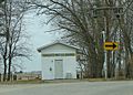
The historic 1898 calaboose, a small jail.
-
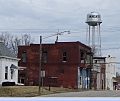
Buildings along Vine Street in Wingate.
-
The water works building in Wingate.


See also
 In Spanish: Wingate (Indiana) para niños
