Yountsville, Indiana facts for kids
Quick facts for kids
Yountsville, Indiana
|
|
|---|---|

Yountsville Community Church
|
|
| Country | United States |
| State | Indiana |
| County | Montgomery |
| Township | Ripley |
| Elevation | 728 ft (222 m) |
| Time zone | UTC-5 (Eastern (EST)) |
| • Summer (DST) | UTC-4 (EDT) |
| ZIP code |
47933
|
| Area code(s) | 765 |
| FIPS code | 18-86282 |
| GNIS feature ID | 446420 |
Yountsville is a small, unincorporated community located in Montgomery County, Indiana, in the United States. It is part of Ripley Township. An unincorporated community is a place where people live together but it does not have its own local government like a city or town.
Contents
History of Yountsville
Yountsville got its name from the Yount family, who were early settlers in the area. One family member, Daniel Yount, built several mills along a small stream that flowed into Sugar Creek.
The Mills and Their Importance
During the 1800s, these mills and other buildings around them provided jobs and supplies for the people living nearby. For example, wool from sheep was brought to the mill. There, it was cleaned, prepared, spun into yarn, dyed, woven into fabric, and then sewn into clothes and blankets. The mills were very important for making everyday items.
The Yount's Woolen Mill stopped working in 1905. Yountsville was a busy little village until the mid-1880s. When railroads became more common, the mills in the area became less important. Today, Yountsville is a quiet place with only a few houses and a local church. One of the old mill buildings, made of brick in 1864, still stands by Sugar Creek. An old boarding house and inn from 1851 is also there, sitting about 60 feet above the mill.
Other Historical Features
A covered bridge, called the Yountsville Covered Bridge, was built in 1848. It crossed Sugar Creek and was used until 1948. Yountsville also had a post office that operated for many years, from 1844 to 1919.
The Church Fire
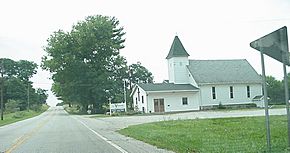
The Yountsville Community Church, which you can see in the picture at the top of this page, was sadly destroyed by a fire on November 13, 2011. The fire started during Sunday services. It was caused by an electrical problem and spread quickly because of strong winds. Luckily, no one from the church was hurt.
Geography of Yountsville
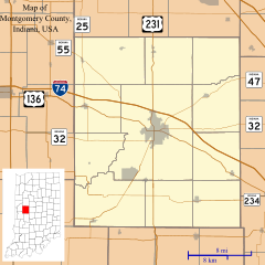
Yountsville is located about four miles west of a town called Crawfordsville. You can find it on State Road 32, just west of the Yountsville bridge.
 | Misty Copeland |
 | Raven Wilkinson |
 | Debra Austin |
 | Aesha Ash |


