Johnson Township, Clinton County, Indiana facts for kids
Quick facts for kids
Johnson Township
|
|
|---|---|
|
Township
|
|

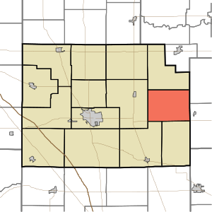
Location of Johnson Township in Clinton County
|
|
| Country | United States |
| State | Indiana |
| County | Clinton |
| Organized | 1843 |
| Named for | Richard Johnson |
| Government | |
| • Type | Indiana township |
| Area | |
| • Total | 26.67 sq mi (69.1 km2) |
| • Land | 26.67 sq mi (69.1 km2) |
| • Water | 0 sq mi (0 km2) |
| Elevation | 912 ft (278 m) |
| Population
(2020)
|
|
| • Total | 450 |
| • Density | 19.2/sq mi (7.4/km2) |
| FIPS code | 18-38628 |
| GNIS feature ID | 453510 |
Johnson Township is a community located in Clinton County, Indiana. It is one of fourteen townships in the county. As of the 2020 census, about 450 people lived here. The township was named after Richard M. Johnson, who was a military officer and later became the Vice President of the United States.
Contents
The Story of Johnson Township
Johnson Township was officially created in March 1843 by county leaders. It was one of the last parts of Clinton County to be settled by white families. This is because the area was originally part of the Big Miami Reserve. This land was set aside for Native American tribes. It wasn't until 1838 that this land became open for new settlers.
The first white settlers arrived in 1839. They were three brothers named George, William, and Charles Thomas. For two years, they were the only residents in the township.
Early Settlements
The township's first social and business center was a place called Burget's Corner. It was located about two and a half miles north of Scircleville. Burget's Corner had a general store and a post office. The post office stayed open for over 30 years. The building that held the store and post office was later moved to Scircleville. It was then used as a saloon.
Another early settlement was Berlin. It was planned in 1847 in the southeastern part of the township. However, Berlin also disappeared during the 1800s.
Where is Johnson Township?
Johnson Township covers an area of about 26.67 square miles (69.1 square kilometers). All of this area is land.
Transportation
A Norfolk Southern rail line runs through the southern part of the township. This railway goes from east to west. It connects the towns of Frankfort and Tipton. This same rail line used to be known as the Lake Erie and Western Railroad. It was also called the Nickel Plate in the past.
Local Communities
Johnson Township includes a few small, unincorporated towns. These are towns that don't have their own local government.
Nearby Places
Johnson Township shares its borders with several other townships:
- Forest Township (to the north)
- Prairie Township, Tipton County (to the northeast)
- Jefferson Township, Tipton County (to the east)
- Sugar Creek Township (to the south)
- Kirklin Township (to the southwest)
- Michigan Township (to the west)
Cemeteries
There are seven cemeteries located within Johnson Township. These include Bacon, Baker, Merrit, Plummer, Prairie Chapel, Scott, and Stroup cemeteries.
 | Misty Copeland |
 | Raven Wilkinson |
 | Debra Austin |
 | Aesha Ash |

