Cass County, Indiana facts for kids
Quick facts for kids
Cass County
|
|
|---|---|

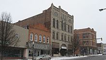
Courthouse Historic District (Logansport)
|
|

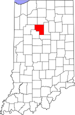
Location within the U.S. state of Indiana
|
|
 Indiana's location within the U.S. |
|
| Country | |
| State | |
| Founded | 1829 |
| Named for | Lewis Cass |
| Seat | Logansport |
| Largest city | Logansport |
| Area | |
| • Total | 414.85 sq mi (1,074.5 km2) |
| • Land | 412.16 sq mi (1,067.5 km2) |
| • Water | 2.69 sq mi (7.0 km2) 0.65%% |
| Population
(2020)
|
|
| • Total | 37,870 |
| • Estimate
(2023)
|
37,666 |
| • Density | 91.286/sq mi (35.246/km2) |
| Time zone | UTC−5 (Eastern) |
| • Summer (DST) | UTC−4 (EDT) |
| Congressional districts | 4th, 2nd |
| Indiana county number 9 | |
Cass County is a place in the state of Indiana, in the United States. It's like a big neighborhood or district. In 2020, about 37,870 people lived here. The main town and center of the county is Logansport. Cass County is also part of a larger area called the Logansport, IN Micropolitan Statistical Area, which helps describe how towns and cities are connected.
Contents
The Story of Cass County
Cass County was officially created in 1828. It was named after a very important person, General Lewis Cass. He was the second governor of Michigan Territory. Later, he even served as the Secretary of War for President Andrew Jackson.
Exploring Cass County's Geography
Cass County covers a total area of about 414.85 square miles. Most of this area, about 412.16 square miles, is land. The rest, about 2.69 square miles, is water. The Wabash River flows through the county towards the west. The Eel River joins the Wabash River in Logansport.
Neighboring Counties
Cass County shares its borders with several other counties:
- Fulton County - to the north
- Miami County - to the east
- Howard County - to the south
- Carroll County - to the southwest
- White County - to the west
- Pulaski County - to the northwest
Cities and Towns in Cass County
The Main City
Smaller Towns
Special Places
- Grissom AFB (most of it is in Miami County)
Unincorporated Communities
These are smaller communities that are not officially cities or towns:
Townships
Cass County is divided into smaller areas called townships:
- Adams
- Bethlehem
- Boone
- Clay
- Clinton
- Deer Creek
- Eel
- Harrison
- Jackson
- Jefferson
- Miami
- Noble
- Tipton
- Washington
Getting Around Cass County
Public Transportation
- Cass Area Transit helps people travel around the county.
Main Roads
These are the major highways that go through Cass County:
 U.S. Route 24
 U.S. Route 35
 Indiana State Road 16
 Indiana State Road 17
 Indiana State Road 18
 Indiana State Road 25
 Indiana State Road 29
 Indiana State Road 218
Railroads
Trains also travel through Cass County on these railway lines:
- Norfolk Southern Railway
- Winamac Southern Railroad
- Logansport and Eel River Shortline Company
- Toledo, Peoria and Western Railway
Weather and Climate in Cass County
| Weather chart for Logansport, Indiana | |||||||||||||||||||||||||||||||||||||||||||||||
|---|---|---|---|---|---|---|---|---|---|---|---|---|---|---|---|---|---|---|---|---|---|---|---|---|---|---|---|---|---|---|---|---|---|---|---|---|---|---|---|---|---|---|---|---|---|---|---|
| J | F | M | A | M | J | J | A | S | O | N | D | ||||||||||||||||||||||||||||||||||||
|
1.7
33
14
|
1.5
38
18
|
2.6
49
28
|
3.1
61
38
|
3.8
73
49
|
3.9
82
59
|
3.5
85
63
|
3.6
83
61
|
3.3
77
53
|
2.7
65
41
|
3.4
51
31
|
2.7
38
21
|
||||||||||||||||||||||||||||||||||||
| temperatures in °F precipitation totals in inches source: The Weather Channel |
|||||||||||||||||||||||||||||||||||||||||||||||
|
Metric conversion
|
|||||||||||||||||||||||||||||||||||||||||||||||
The weather in Logansport, the main city, changes throughout the year. In January, the average low temperature is about 14°F. In July, the average high temperature is around 85°F. The coldest temperature ever recorded was -24°F in January 1985. The hottest was 104°F in June 1988. The county usually gets the most rain in June, about 3.89 inches. February is usually the driest month, with about 1.53 inches of rain.
Who Lives in Cass County?
| Historical population | |||
|---|---|---|---|
| Census | Pop. | %± | |
| 1830 | 1,162 | — | |
| 1840 | 5,480 | 371.6% | |
| 1850 | 11,021 | 101.1% | |
| 1860 | 16,843 | 52.8% | |
| 1870 | 24,193 | 43.6% | |
| 1880 | 27,611 | 14.1% | |
| 1890 | 31,152 | 12.8% | |
| 1900 | 34,545 | 10.9% | |
| 1910 | 36,368 | 5.3% | |
| 1920 | 38,333 | 5.4% | |
| 1930 | 34,518 | −10.0% | |
| 1940 | 36,908 | 6.9% | |
| 1950 | 38,793 | 5.1% | |
| 1960 | 40,931 | 5.5% | |
| 1970 | 40,456 | −1.2% | |
| 1980 | 40,936 | 1.2% | |
| 1990 | 38,413 | −6.2% | |
| 2000 | 40,930 | 6.6% | |
| 2010 | 38,966 | −4.8% | |
| 2020 | 37,870 | −2.8% | |
| 2023 (est.) | 37,666 | −3.3% | |
| US Decennial Census 1790-1960 1900-1990 1990-2000 2010 |
|||
In 2010, there were 38,966 people living in Cass County. There were about 14,858 households, which are groups of people living together. The population density was about 94.5 people per square mile. Most people (88.2%) were white. About 12.6% of the population was of Hispanic or Latino background. Many people in the county have German, American, Irish, or English family roots.
About one-third of the households had children under 18 living with them. The average age of people in the county was about 38.7 years old. The average income for a household was around $47,697 per year. About 14% of the population lived below the poverty line. This included 18.7% of those under 18 years old.
2020 Census Update
By the 2020 United States Census, the population of Cass County was 37,870 people.
| Race | Number of People | Percentage |
|---|---|---|
| White (not Hispanic) | 28,744 | 76% |
| Black or African American (not Hispanic) | 560 | 1.5% |
| Native American (not Hispanic) | 109 | 0.3% |
| Asian (not Hispanic) | 573 | 1.5% |
| Pacific Islander (not Hispanic) | 8 | 0.02% |
| Other/Mixed (not Hispanic) | 1,201 | 3.17% |
| Hispanic or Latino | 6,675 | 17.6% |
Famous People from Cass County
- Rollie Zeider (1883–1967) was a professional baseball player. He played in the major leagues from 1910 to 1918. He was born in Hoover.
- Film actor Greg Kinnear was born in Logansport.
- Cpl. Humberto Sanchez (1998–2021) was a U.S. Marine. He was one of the 13 service members who died in the 2021 bombing at the Kabul airport.
Schools in Cass County
Several school districts serve different parts of Cass County:
- Caston School Corporation
- Logansport Community School Corporation
- Pioneer Regional School Corporation
- Southeastern School Corporation
High Schools and Middle Schools
- 6th Grade Academy
- Lewis Cass High School
- Logansport Junior High School
- Logansport High School
- Pioneer Junior – Senior High School
Elementary Schools
- Columbia Elementary School
- Fairview Elementary School
- Franklin Elementary School
- Galveston Elementary School
- Landis Elementary School
- Pioneer Elementary School
- Thompson Elementary School
See also
 In Spanish: Condado de Cass (Indiana) para niños
 | Victor J. Glover |
 | Yvonne Cagle |
 | Jeanette Epps |
 | Bernard A. Harris Jr. |

