Miami County, Indiana facts for kids
Quick facts for kids
Miami County
|
|
|---|---|

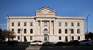
Miami County Courthouse in Peru, Indiana
|
|

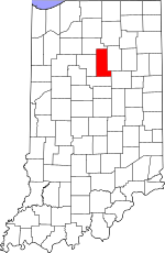
Location within the U.S. state of Indiana
|
|
 Indiana's location within the U.S. |
|
| Country | |
| State | |
| Founded | January 30, 1833 |
| Named for | Miami tribe |
| Seat | Peru |
| Largest city | Peru |
| Area | |
| • Total | 377.39 sq mi (977.4 km2) |
| • Land | 373.84 sq mi (968.2 km2) |
| • Water | 3.55 sq mi (9.2 km2) 0.94%% |
| Population
(2020)
|
|
| • Total | 35,962 |
| • Estimate
(2023)
|
35,402 |
| • Density | 95.2913/sq mi (36.7922/km2) |
| Time zone | UTC−5 (Eastern) |
| • Summer (DST) | UTC−4 (EDT) |
| Congressional district | 2nd |
| Indiana county number 52 | |
Miami County is a county in the state of Indiana, USA. In 2020, about 35,962 people lived here. The main city, or county seat, is Peru. Miami County is also part of a larger area called the Kokomo-Peru CSA.
Contents
History of Miami County
Indiana became a state on December 11, 1816. Before that, it was known as the Indiana Territory for 16 years. Even earlier, Indiana was part of the Northwest Territory. This large area was gained by the British after the French and Indian War. After the American Revolution, more people from Europe started to settle there.
Miami County was officially created in 1832. It was formed from parts of Cass County and other undeveloped land. The county was named after the Miami tribe, a group of Native American people. Many members of the Miami tribe still live in this area today.
Over the years, the county's shape changed a bit. In 1834, Miami County grew larger on its western side. A small piece of land was added to the northeast in 1838. However, that land was later given to Fulton County in 1844. Miami County has kept its current shape since 1844.
Geography of Miami County
Miami County covers a total area of about 377 square miles. Most of this area, about 374 square miles, is land. The remaining small part, about 3.5 square miles, is water.
Counties Nearby
Miami County shares borders with these other counties:
- Fulton County (to the north)
- Wabash County (to the east)
- Grant County (to the southeast)
- Howard County (to the south)
- Cass County (to the west)
Main Roads and Highways
Communities in Miami County
Miami County has one main city and several towns and smaller places.
City
Towns
Census-Designated Places
These are areas that are like towns but not officially incorporated:
- Grissom AFB
- Mexico
Other Small Places
- Bennetts Switch
- Birmingham
- Chili
- Courter
- Deedsville
- Doyle
- Erie
- Flora
- Gilead
- Loree
- McGrawsville
- Miami
- Nead
- New Santa Fe
- North Grove
- Oakdale
- Oakley
- Park View Heights
- Peoria
- Perrysburg
- Pettysville
- Santa Fe
- South Peru
- Stockdale
- Wawpecong
- Wells
Places That No Longer Exist
Townships
Miami County is divided into several smaller areas called townships:
- Allen Township
- Butler Township
- Clay Township
- Deer Creek Township
- Erie Township
- Harrison Township
- Jackson Township
- Jefferson Township
- Perry Township
- Peru Township
- Pipe Creek Township
- Richland Township
- Union Township
- Washington Township
Climate and Weather
| Weather chart for Peru, Indiana | |||||||||||||||||||||||||||||||||||||||||||||||
|---|---|---|---|---|---|---|---|---|---|---|---|---|---|---|---|---|---|---|---|---|---|---|---|---|---|---|---|---|---|---|---|---|---|---|---|---|---|---|---|---|---|---|---|---|---|---|---|
| J | F | M | A | M | J | J | A | S | O | N | D | ||||||||||||||||||||||||||||||||||||
|
2.2
31
14
|
1.9
36
17
|
2.7
47
27
|
3.5
60
37
|
4.1
71
48
|
4.2
80
58
|
4.1
83
61
|
4
81
59
|
3.2
75
51
|
2.8
63
40
|
3.1
49
31
|
2.7
36
20
|
||||||||||||||||||||||||||||||||||||
| temperatures in °F precipitation totals in inches source: The Weather Channel |
|||||||||||||||||||||||||||||||||||||||||||||||
|
Metric conversion
|
|||||||||||||||||||||||||||||||||||||||||||||||
In Peru, Indiana, the average temperatures change throughout the year. The coldest month is usually January, with lows around 14°F. The warmest month is July, with highs around 83°F.
However, temperatures can sometimes be much more extreme. The lowest temperature ever recorded in January was -24°F in 1985. The highest temperature ever recorded was 103°F in June 1988.
The amount of rain and snow also varies each month. February usually has the least amount of precipitation, about 1.89 inches. June typically has the most, with about 4.23 inches.
Population and People
| Historical population | |||
|---|---|---|---|
| Census | Pop. | %± | |
| 1840 | 3,048 | — | |
| 1850 | 11,304 | 270.9% | |
| 1860 | 16,851 | 49.1% | |
| 1870 | 21,052 | 24.9% | |
| 1880 | 24,083 | 14.4% | |
| 1890 | 25,823 | 7.2% | |
| 1900 | 28,344 | 9.8% | |
| 1910 | 29,350 | 3.5% | |
| 1920 | 28,668 | −2.3% | |
| 1930 | 29,032 | 1.3% | |
| 1940 | 27,926 | −3.8% | |
| 1950 | 28,201 | 1.0% | |
| 1960 | 38,000 | 34.7% | |
| 1970 | 39,246 | 3.3% | |
| 1980 | 39,820 | 1.5% | |
| 1990 | 36,897 | −7.3% | |
| 2000 | 36,082 | −2.2% | |
| 2010 | 36,903 | 2.3% | |
| 2020 | 35,962 | −2.5% | |
| 2023 (est.) | 35,402 | −4.1% | |
| U.S. Decennial Census 1790-1960 1900-1990 1990-2000 2010-2013 |
|||
In 2010, Miami County had 36,903 people living there. There were about 13,456 households, which are groups of people living together. Most people in the county were white (91.8%). Other groups included black or African American (4.5%) and American Indian (0.9%).
About 32.5% of households had children under 18 living with them. Most households (53.2%) were married couples. The average age of people in the county was 39.5 years old.
The average income for a household in the county was about $47,697 per year. For families, it was about $49,282. About 16.7% of all people in the county lived below the poverty line. This included 26.6% of those under 18 years old.
Major Employers
Some of the biggest employers in Miami County include:
- Ferrellgas (Peru)
- Schneider Electric Square D (Peru)
- Miami Correctional Facility (Bunker Hill)
- Indiana Correction Dept (Bunker Hill)
- Armour-Eckrich Meats (Peru)
- American Stationery Co (Peru) [1]
- Dukes Memorial Hospital (Peru) [2]
- Miami County (Peru)
- Bryan Steam LLC (Peru) [3]
- Snavely Machine & Mfg Co Inc (Peru)
See also
 In Spanish: Condado de Miami (Indiana) para niños
 | Kyle Baker |
 | Joseph Yoakum |
 | Laura Wheeler Waring |
 | Henry Ossawa Tanner |

