Mexico, Indiana facts for kids
Quick facts for kids
Mexico, Indiana
|
|
|---|---|

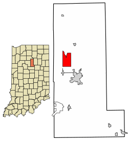
Location in Miami County, Indiana
|
|
| Country | United States |
| State | Indiana |
| County | Miami |
| Township | Jefferson |
| Area | |
| • Total | 5.56 sq mi (14.40 km2) |
| • Land | 5.49 sq mi (14.22 km2) |
| • Water | 0.07 sq mi (0.18 km2) |
| Elevation | 659 ft (201 m) |
| Population
(2020)
|
|
| • Total | 915 |
| • Density | 166.7/sq mi (64.4/km2) |
| Time zone | UTC-5 (Eastern (EST)) |
| • Summer (DST) | UTC-4 (EDT) |
| ZIP code |
46958
|
| Area code(s) | 765 |
| FIPS code | 18-48636 |
| GNIS feature ID | 2393126 |
Mexico is a small community in Miami County, Indiana, in the United States. It's known as a census-designated place (CDP), which means it's an area identified by the government for statistics, but it doesn't have its own local government like a city or town. In 2020, about 915 people lived here.
Mexico's History
Mexico was officially planned and marked out on a map, a process called "platting," in 1834. The community's name likely celebrates the Mexican War of Independence, a big event that happened not too long before Mexico, Indiana, was founded.
This area was first settled along an old Native American trail that followed the Eel River. This trail later became the Michigan Road, which was the very first road built in Miami County. Along this important road was the River House Inn. This inn was owned by the parents of a famous Indiana poet named Dulciana Minerva Mason. At the time, it was the only place to stop and rest between the cities of Indianapolis and Michigan City. Mexico has had its own post office since 1837, helping people send and receive mail for a very long time!
Where is Mexico Located?
Mexico is found in the northwest part of Miami County. The center of the community is just a short distance east of U.S. Route 31. This major highway forms the western edge of the Mexico area. If you travel north on US 31, you'll reach Rochester in about 18 miles. If you go south, you'll get to Kokomo in about 23 miles. Peru, which is the main town and county seat of Miami County, is about 5 miles southeast of Mexico.
The Mexico area covers about 5.56 square miles (or 14.40 square kilometers). Most of this area is land, with a small part, about 0.07 square miles (0.18 square kilometers), being water. The Eel River flows through Mexico, passing east and south of the town center. This river eventually joins the Wabash River near Logansport.
Who Lives in Mexico?
The number of people living in Mexico has changed over the years:
| Historical population | |||
|---|---|---|---|
| Census | Pop. | %± | |
| 1990 | 1,003 | — | |
| 2000 | 984 | −1.9% | |
| 2010 | 836 | −15.0% | |
| 2020 | 915 | 9.4% | |
| U.S. Decennial Census | |||
In 2000, there were 984 people living in Mexico. Most of the people living here were White. A small number of people were from other backgrounds, including African American, Native American, and Pacific Islander. Some people were also of Hispanic or Latino heritage.
The people living in Mexico are of all ages. In 2000, about 21% of the population was under 18 years old, and about 15% were 65 years old or older. The average age of people in Mexico was 42 years. There were slightly more males than females in the community.
See also
 In Spanish: Mexico (Indiana) para niños
 | Sharif Bey |
 | Hale Woodruff |
 | Richmond Barthé |
 | Purvis Young |

