
Lee, Indiana facts for kids
Quick facts for kids
Lee, Indiana
|
|
|---|---|

View north from Madison Street toward corn fields and grain elevators
|
|

Lee, Indiana
Location in Indiana

Lee, Indiana
Location in the United States
|
|
| Country | United States |
| State | Indiana |
| County | White |
| Township | Monon |
| Established | 1883 |
| Platted | August 1886 |
| Named for | John Lee |
| Elevation | 673 ft (205 m) |
| Time zone | UTC-5 (Eastern (EST)) |
| • Summer (DST) | UTC-4 (EDT) |
| ZIP code |
47978
|
| FIPS code | 18-42642 |
| GNIS feature ID | 437727 |
Lee is a small, unincorporated community located in Monon Township, White County, in the U.S. state of Indiana. This means it's a place where people live, but it doesn't have its own local government like a city or town. It's part of White County in the state of Indiana, USA.
Contents
History of Lee, Indiana
Lee first started as a train stop on the Indianapolis, Delphi and Chicago Railroad. This railroad company finished building its first 40 miles of track by late 1879. The tracks connected the towns of Rensselaer and Delphi.
Early Days and Naming
On October 25, 1880, a post office was opened in Lee. It helped deliver mail to the farms and homes northwest of Monon. Calvin Anderson was the first postmaster. Around 1884, the railroad line became known as the Monon Route.
The community of Lee was officially started in 1883. It was named after John Lee, who was the president of the ID&C Railroad. He also opened a place for farmers to sell their grain there.
Farming and Shipping Center
Lee was located in a very good area for farming. The land was rich and perfect for raising animals. It was also an important place for selling and shipping grain. Farmers also shipped hundreds of tons of hay from Lee every year.
In August 1886, the area was officially mapped out, or "platted," under the name Oakdale. Noble J. York and Benjamin A. Linville did this. However, most people still called the community Lee. In 1949, one of Lee's streets was closed off after a request from the community.
Post Office and Train Service
Lee's post office closed on June 30, 1933. Today, the train line through Lee is part of the CSX Transportation Monon Subdivision. Amtrak trains also use this line. Even though Lee is shown on Amtrak maps, the Cardinal train (and the Hoosier State train before it) does not stop there.
In 2016, a book called History and Reflections of Lee, Indiana was published. It was written by Helen Louise George, who lived in the area for 88 years. The book tells the story of Lee.
Geography of Lee
Lee is located at 40°53′47″N 86°58′05″W / 40.89639°N 86.96806°W. This spot is about 5 miles northwest of Monon. You can find it near where County Roads 1000 North and 500 West meet. The train tracks between Monon and Rensselaer also run through Lee.
The farms around Lee are drained by a stream called Slough Creek. This creek flows into the Iroquois River. Slough Creek runs just south of Lee and flows towards the west.
Images for kids
-
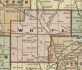
White County map, 1908
-
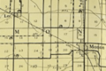
Monon Township map detail, 1920
-

Abandoned church in Lee in 2019

.png)

