Round Grove Township, White County, Indiana facts for kids
Quick facts for kids
Round Grove Township
|
|
|---|---|

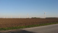
Part of the Meadow Lake Wind Farm in the township
|
|

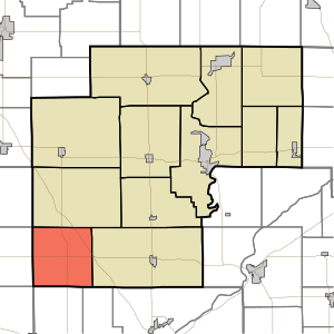
Location in White County
|
|
| Country | United States |
| State | Indiana |
| County | White |
| Government | |
| • Type | Indiana township |
| Area | |
| • Total | 35.51 sq mi (92.0 km2) |
| • Land | 35.48 sq mi (91.9 km2) |
| • Water | 0.03 sq mi (0.08 km2) 0.08% |
| Elevation | 728 ft (222 m) |
| Population
(2020)
|
|
| • Total | 252 |
| • Density | 7.097/sq mi (2.740/km2) |
| ZIP codes |
47906, 47923
|
| GNIS feature ID | 453815 |
Round Grove Township is one of twelve townships in White County, Indiana, United States. It is a local government area. As of the 2020 census, its population was 252 people. There were 100 housing units in the township.
Round Grove Township was created in 1858. The township got its name from a special round group of trees. This grove used to be in the southern part of the township.
Contents
How Many People Live Here?
The number of people living in Round Grove Township has changed over the years. This table shows the population counts from different U.S. censuses.
| Historical population | |||
|---|---|---|---|
| Census | Pop. | %± | |
| 1890 | 779 | — | |
| 1900 | 890 | 14.2% | |
| 1910 | 628 | −29.4% | |
| 1920 | 641 | 2.1% | |
| 1930 | 537 | −16.2% | |
| 1940 | 494 | −8.0% | |
| 1950 | 446 | −9.7% | |
| 1960 | 418 | −6.3% | |
| 1970 | 382 | −8.6% | |
| 1980 | 282 | −26.2% | |
| 1990 | 250 | −11.3% | |
| 2000 | 246 | −1.6% | |
| 2010 | 259 | 5.3% | |
| 2020 | 252 | −2.7% | |
| Source: US Decennial Census | |||
Land and Water Areas
Round Grove Township covers a total area of about 35.51 square miles. Most of this area is land. About 35.48 square miles (which is 99.92%) is land. Only a very small part, about 0.03 square miles (0.08%), is water.
Towns in the Township
- Round Grove is a small community within the township. It is not officially a city or town. This list might include places that were once settlements.
Neighboring Townships
Round Grove Township shares its borders with several other townships. These are the areas next to it:
- West Point Township (to the north)
- Prairie Township (to the east)
- Wabash Township, Tippecanoe County (to the southeast)
- Shelby Township, Tippecanoe County (to the south)
- Bolivar Township, Benton County (to the southwest)
- Pine Township, Benton County (to the west)
- Gilboa Township, Benton County (to the northwest)
Local Schools
The children in Round Grove Township attend schools run by the Tri-County School Corporation.
See also
 In Spanish: Municipio de Round Grove (Indiana) para niños
 | William L. Dawson |
 | W. E. B. Du Bois |
 | Harry Belafonte |

