
Grafton County, New Hampshire facts for kids
Quick facts for kids
Grafton County
|
|
|---|---|

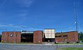
Grafton County Courthouse in Haverhill
|
|

Location within the U.S. state of New Hampshire
|
|
 New Hampshire's location within the U.S. |
|
| Country | |
| State | |
| Founded | 1769 |
| Named for | Augustus FitzRoy, 3rd Duke of Grafton |
| Seat | Haverhill |
| Largest city | Lebanon |
| Area | |
| • Total | 1,749.7 sq mi (4,532 km2) |
| • Land | 1,708.6 sq mi (4,425 km2) |
| • Water | 41.1 sq mi (106 km2) 2.3% |
| Population
(2020)
|
|
| • Total | 91,118 |
| • Estimate
(2022)
|
91,126 |
| • Density | 53.3/sq mi (20.6/km2) |
| Time zone | UTC−5 (Eastern) |
| • Summer (DST) | UTC−4 (EDT) |
| Congressional districts | 1st, 2nd |
| Website | co.grafton.nh.us |
Grafton County is a county in the state of New Hampshire, USA. In 2020, about 91,118 people lived here. The main town, or county seat, is Haverhill. The county offices moved to North Haverhill in 1972.
Grafton County is part of the Claremont-Lebanon, NH–VT Micropolitan Statistical Area. This means it's a smaller urban area with strong ties to nearby towns.
This county is home to two important colleges: Dartmouth College and Plymouth State University. In 2006, Progressive Farmer magazine said Grafton County was one of the "Best Places to Live in Rural America." They liked its low unemployment and the beautiful White Mountain National Forest.
Contents
History of Grafton County
Grafton was one of the first five counties created in New Hampshire in 1769. It was named after Augustus FitzRoy, 3rd Duke of Grafton. He was the British Prime Minister at the time and supported the American colonies in Parliament.
The county was officially set up in Haverhill in 1771. It used to be much bigger, covering all of northern New Hampshire. Some towns now in Vermont were even part of it! In 1803, the northern part became Coos County. By 1797, Grafton County had 50 towns and about 23,093 people.
Geography of Grafton County
Grafton County covers about 1,750 square miles. Most of this area, about 1,709 square miles, is land. The rest, about 41 square miles, is water. It is the second-largest county in New Hampshire by size.
This county is very rural, meaning it has lots of open land and small towns. About half of its area is part of the beautiful White Mountain National Forest. You can find Squam Lake here, which was featured in the movie On Golden Pond. The famous Old Man of the Mountain landmark was also here before it fell in 2003.
Many of New Hampshire's tallest mountains, called "4,000-footers," are in Grafton County. The famous Appalachian Trail, a long hiking path, also goes through many towns in the county.
Neighboring Counties
- Essex County, Vermont (north)
- Coos County (northeast)
- Carroll County (east)
- Belknap County (southeast)
- Merrimack County (south)
- Sullivan County (south)
- Windsor County, Vermont (southwest)
- Orange County, Vermont (west)
- Caledonia County, Vermont (northwest)
Protected Natural Areas
- White Mountain National Forest (part)
Population in Grafton County
| Historical population | |||
|---|---|---|---|
| Census | Pop. | %± | |
| 1790 | 13,468 | — | |
| 1800 | 23,093 | 71.5% | |
| 1810 | 28,462 | 23.2% | |
| 1820 | 32,989 | 15.9% | |
| 1830 | 38,682 | 17.3% | |
| 1840 | 42,311 | 9.4% | |
| 1850 | 42,343 | 0.1% | |
| 1860 | 42,260 | −0.2% | |
| 1870 | 39,103 | −7.5% | |
| 1880 | 38,788 | −0.8% | |
| 1890 | 37,217 | −4.1% | |
| 1900 | 40,844 | 9.7% | |
| 1910 | 41,652 | 2.0% | |
| 1920 | 40,572 | −2.6% | |
| 1930 | 42,816 | 5.5% | |
| 1940 | 44,645 | 4.3% | |
| 1950 | 47,923 | 7.3% | |
| 1960 | 48,857 | 1.9% | |
| 1970 | 54,914 | 12.4% | |
| 1980 | 65,806 | 19.8% | |
| 1990 | 74,929 | 13.9% | |
| 2000 | 81,743 | 9.1% | |
| 2010 | 89,118 | 9.0% | |
| 2020 | 91,118 | 2.2% | |
| 2022 (est.) | 91,126 | 2.3% | |
| U.S. Decennial Census 1790-1960 1900-1990 1990-2000 2010-2018 |
|||
In 2010, there were 89,118 people living in Grafton County. About 93.6% of the people were white. Other groups included 3.0% Asian, 0.9% Black or African American, and 0.4% American Indian. About 1.8% of the people were of Hispanic or Latino background.
The average age of people in the county was 41.2 years old.
Towns and Communities
City
Towns
- Alexandria
- Ashland
- Bath
- Benton
- Bethlehem
- Bridgewater
- Bristol
- Campton
- Canaan
- Dorchester
- Easton
- Ellsworth
- Enfield
- Franconia
- Grafton
- Groton
- Hanover
- Haverhill (county seat)
- Hebron
- Holderness
- Landaff
- Lincoln
- Lisbon
- Littleton
- Lyman
- Lyme
- Monroe
- Orange
- Orford
- Piermont
- Plymouth
- Rumney
- Sugar Hill
- Thornton
- Warren
- Waterville Valley
- Wentworth
- Woodstock
Township
Census-Designated Places
Villages
- East Hebron
- Enfield Center
- Etna
- Glencliff
- Lyme Center
- Montcalm
- Pike
- Stinson Lake
- West Lebanon
Education
Grafton County has many school districts. They are organized to serve students from kindergarten through 12th grade (K-12), or just secondary (high school), or elementary (younger grades).
Unified (K-12) School Districts:
- Benton School District
- Ellsworth School District
- Haverhill Cooperative School District
- Lebanon School District
- Lincoln-Woodstock School District
- Lisbon Regional School District
- Littleton School District
- Mascoma Valley Regional School District
- Newfound Area School District
- Rivendell Interstate School District
Secondary (High School) School Districts:
- Dresden School District
- Profile School District
- Pemi-Baker Regional School District
Elementary School Districts:
- Ashland School District
- Bath School District
- Bethlehem School District
- Campton School District
- Hanover School District
- Holderness School District
- Lafayette Regional School District
- Landaff School District
- Lyme School District
- Monroe School District
- Piermont School District
- Plymouth School District
- Rumney School District
- Thornton School District
- Warren School District
- Waterville Valley School District
- Wentworth School District
Images for kids
-
Grafton County Courthouse in Haverhill
See also
 In Spanish: Condado de Grafton para niños
