North Woodstock, New Hampshire facts for kids
Quick facts for kids
North Woodstock, New Hampshire
|
|
|---|---|

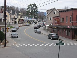
Main Street in North Woodstock
|
|
| Country | United States |
| State | New Hampshire |
| County | Grafton |
| Town | Woodstock |
| Area | |
| • Total | 1.65 sq mi (4.28 km2) |
| • Land | 1.62 sq mi (4.18 km2) |
| • Water | 0.04 sq mi (0.09 km2) |
| Elevation | 738 ft (225 m) |
| Population
(2020)
|
|
| • Total | 739 |
| • Density | 457.30/sq mi (176.60/km2) |
| Time zone | UTC-5 (Eastern (EST)) |
| • Summer (DST) | UTC-4 (EDT) |
| ZIP code |
03262
|
| Area code(s) | 603 |
| FIPS code | 33-57220 |
| GNIS feature ID | 0872411 |
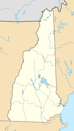
North Woodstock is a small community in New Hampshire, United States. It is a census-designated place (CDP), which means it's a special area defined by the government for counting people. North Woodstock is the main village within the larger town of Woodstock. It is located in Grafton County.
In 2020, about 739 people lived in North Woodstock. It's a quiet place known for its natural beauty.
Contents
Exploring North Woodstock's Location
North Woodstock is found in the northern part of the town of Woodstock. It is right next to the town of Lincoln. The village center is where two important roads meet: U.S. Route 3 (also called Main Street) and New Hampshire Route 112. Route 112 is famous for the Kancamagus Highway.
Major Roads and Travel
Interstate 93 goes through the eastern part of North Woodstock. You can get onto I-93 from Exit 32, which is on Route 112. This highway can take you south to Plymouth (about 21 miles away). If you go north, you'll pass through Franconia Notch and reach Littleton (about 23 miles away).
Route 112 heads east along the Kancamagus Highway for about 36 miles to Conway. If you go west on Route 112, you'll travel through Kinsman Notch to Woodsville, which is about 24 miles away. U.S. Route 3 is a local road that runs next to I-93.
Rivers and Waterways
The Pemigewasset River flows right through the middle of North Woodstock. Two other rivers, the East Branch of the Pemigewasset and Moosilauke Brook, join the Pemigewasset River at the southern edge of the village.
Most of North Woodstock's area is land, about 1.62 square miles. A small part, about 0.04 square miles, is water.
Who Lives in North Woodstock?
| Historical population | |||
|---|---|---|---|
| Census | Pop. | %± | |
| 2010 | 528 | — | |
| 2020 | 739 | 40.0% | |
| U.S. Decennial Census | |||
In 2010, there were 528 people living in North Woodstock. By 2020, the population grew to 739 people.
Homes and Families
In 2010, there were 256 households in North Woodstock. A household is a group of people living together in one home. Many homes, especially vacation properties, were empty for part of the year.
Most people living in North Woodstock are white. A small number of people are from other racial backgrounds, including Asian and Native American.
Age of Residents
The average age of people in North Woodstock in 2010 was about 44.5 years old.
- About 17% of residents were under 18 years old.
- About 7.8% were between 18 and 24 years old.
- About 26% were between 25 and 44 years old.
- About 33% were between 45 and 64 years old.
- About 16% were 65 years old or older.
Income Information
From 2011 to 2015, the estimated average yearly income for a household in North Woodstock was about $40,083. For families, the average income was around $42,292. The average income per person was about $32,940.
See also

- In Spanish: North Woodstock (Nuevo Hampshire) para niños
 | DeHart Hubbard |
 | Wilma Rudolph |
 | Jesse Owens |
 | Jackie Joyner-Kersee |
 | Major Taylor |


