
Woodstock, New Hampshire facts for kids
Quick facts for kids
Woodstock, New Hampshire
|
|
|---|---|
|
Town
|
|
 |
|

Location in Grafton County, New Hampshire
|
|
| Country | United States |
| State | New Hampshire |
| County | Grafton |
| Incorporated | 1763 |
| Villages | Woodstock North Woodstock |
| Area | |
| • Total | 59.3 sq mi (153.6 km2) |
| • Land | 58.8 sq mi (152.2 km2) |
| • Water | 0.5 sq mi (1.4 km2) 0.93% |
| Elevation | 741 ft (226 m) |
| Population
(2020)
|
|
| • Total | 1,434 |
| • Density | 24/sq mi (9.4/km2) |
| Time zone | UTC−5 (Eastern) |
| • Summer (DST) | UTC−4 (Eastern) |
| ZIP Codes |
03262 (North Woodstock)
03293 (Woodstock) |
| Area code(s) | 603 |
| FIPS code | 33-87060 |
| GNIS feature ID | 0873761 |
Woodstock is a town in Grafton County, New Hampshire, United States. In 2020, about 1,434 people lived here. Woodstock is home to the village of North Woodstock, which is the main business area.
Much of Woodstock is covered by forests. It includes the Hubbard Brook Experimental Forest, where scientists study nature. Parts of the White Mountain National Forest are also found here. The famous Appalachian Trail passes through the town's northwestern side. You can also find Russell Pond Campground and the Lost River Reservation nearby.
Contents
History of Woodstock
Early Beginnings and Names
Woodstock was first given land in 1763. The British colonial Governor, Benning Wentworth, named it "Peeling" after a town in England. Many of the first settlers came from Lebanon, Connecticut.
In 1771, Governor John Wentworth, who was Benning's nephew, changed the name to "Fairfield." This new name came from Fairfield, Connecticut. The town was renamed "Woodstock" in 1840. This name might have come from Blenheim Palace in Woodstock, England, or from a popular novel called Woodstock by Walter Scott.
Logging and Tourism Growth
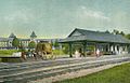
In the early days, logging was a very important industry. Sawmills used the power of the Pemigewasset River to cut wood. When the railroad arrived in the 1800s, it helped transport wood products to markets.
The railroad also brought many tourists to the area. They were often drawn by beautiful paintings of the region by White Mountain artists. Several inns and hotels were built for wealthy visitors. These visitors wanted to escape the hot, humid, and polluted cities like Boston and New York. They enjoyed carriage rides through the White Mountains and exploring the Lost River area.
Changes with Automobiles
When cars became popular, people could travel more freely. They no longer had to rely on train stations. Because of this, many large hotels near train depots closed down. However, North Woodstock is still a popular place for tourists today.
The Hubbard Brook Experimental Forest is in the southern part of Woodstock. It's like an outdoor lab where the United States Forest Service studies ecology, which is how living things interact with their environment. It was started in 1955.
-
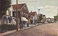
A street scene around 1910
-
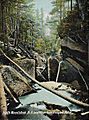
The Lost River around 1908
-
The Deer Park Hotel around 1908
-
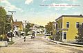
Main Street in 1916


Geography and Rivers
Woodstock is located in the White Mountains region of northern New Hampshire. It is close to the center of Grafton County. The town covers about 153.6 square kilometers (59.3 square miles) in total. Most of this area is land, with a small part being water.
The Pemigewasset River flows through the eastern part of Woodstock. Other streams and rivers in Woodstock that flow into the Pemigewasset include Hubbard Brook, Glover Brook, Moosilauke Brook, the Lost River, and the East Branch Pemigewasset River.
The highest point in Woodstock is the top of Mount Jim. It is about 4,172 feet (1,272 meters) above sea level. This mountain is part of Mount Moosilauke.
Major Roads
Several important roads pass through Woodstock. These include Interstate 93, U.S. Route 3, and state routes 112 and 175.
Population and People


| Historical population | |||
|---|---|---|---|
| Census | Pop. | %± | |
| 1840 | 472 | — | |
| 1850 | 418 | −11.4% | |
| 1860 | 476 | 13.9% | |
| 1870 | 405 | −14.9% | |
| 1880 | 367 | −9.4% | |
| 1890 | 341 | −7.1% | |
| 1900 | 628 | 84.2% | |
| 1910 | 1,083 | 72.5% | |
| 1920 | 684 | −36.8% | |
| 1930 | 756 | 10.5% | |
| 1940 | 981 | 29.8% | |
| 1950 | 894 | −8.9% | |
| 1960 | 827 | −7.5% | |
| 1970 | 897 | 8.5% | |
| 1980 | 1,008 | 12.4% | |
| 1990 | 1,167 | 15.8% | |
| 2000 | 1,139 | −2.4% | |
| 2010 | 1,374 | 20.6% | |
| 2020 | 1,434 | 4.4% | |
| U.S. Decennial Census | |||

In 2010, there were 1,374 people living in Woodstock. There were 624 households, which are groups of people living together. About 353 of these were families.
Most of the people in Woodstock are White (96.9%). A small number of people are from other racial backgrounds. About 0.3% of the population identified as Hispanic or Latino.
About 19.2% of the people in Woodstock were under 18 years old. The median age, which is the middle age of all the people, was 44.2 years. For every 100 females, there were about 102 males.
The average income for a household in Woodstock was about $49,063 per year between 2011 and 2015. For families, the average income was about $62,500.
See also
 In Spanish: Woodstock (Nuevo Hampshire) para niños
