Pemigewasset River facts for kids
Quick facts for kids Pemigewasset River |
|
|---|---|

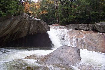
The Pemigewasset River descends into the Basin in Franconia Notch.
|
|
| Country | United States |
| State | New Hampshire |
| Counties | Grafton, Belknap, Merrimack |
| Towns and city | Franconia, Lincoln, Woodstock, Thornton, Campton, Plymouth, Holderness, Ashland, Bridgewater, New Hampton, Bristol, Hill, Sanbornton, Franklin |
| Physical characteristics | |
| Main source | Franconia Notch Franconia 1,980 ft (600 m) 44°10′18″N 71°41′14″W / 44.17167°N 71.68722°W |
| River mouth | Merrimack River Franklin 262 ft (80 m) 43°26′11″N 71°38′54″W / 43.43639°N 71.64833°W |
| Length | 65.0 mi (104.6 km) |
| Basin features | |
| Tributaries |
|
The Pemigewasset River, often called "The Pemi" by locals, is a cool river in New Hampshire, United States. It's about 65 miles (105 km) long. This river and its smaller streams drain an area of about 1,021 square miles (2,644 km²). The name "Pemigewasset" comes from the Abenaki language, meaning "where side current is." This refers to how other streams join the main river.
Exploring the Pemigewasset River
The Pemigewasset River starts at Profile Lake in Franconia Notch State Park. This is in the town of Franconia. It flows south through the amazing White Mountains. Eventually, it joins with the Winnipesaukee River. Together, they form the Merrimack River in Franklin. The Merrimack River then travels through southern New Hampshire and northeastern Massachusetts. Finally, it empties into the Atlantic Ocean.
The Interstate 93 highway runs right next to the river. You can see it between Franconia Notch and New Hampton. The river flows through many towns. These include Lincoln, North Woodstock, Woodstock, Thornton, Campton, Plymouth, Holderness, Ashland, Bridgewater, Bristol, New Hampton, Hill, Sanbornton, and Franklin.
River's Journey and Features
The river creates beautiful waterfalls in Franconia Notch. One famous spot is "The Basin." It also has cool cascades in North Woodstock. You can see Livermore Falls just north of Plymouth. The northern part of the Pemi, from Lincoln to Ashland, has many gravel bars. This makes it a popular spot for boaters and people who like to fish.
Further south, near Ashland, the river is held back by the Ayers Island Dam. This dam helps create electricity. Below this dam, there's a short section of fast-moving water. After that, the river slows down again. It enters the area for the Franklin Falls flood control reservoir. The river then crosses one more dam. Finally, it meets the Winnipesaukee River in the middle of Franklin.
The Pemigewasset watershed is a large area. It includes over 1,100 miles (1,770 km) of rivers. It also has about 17,000 acres (69 km²) of lakes, ponds, and reservoirs. This watershed makes up about 20 percent of the Merrimack River's entire watershed.
Main Rivers Joining the Pemi
Many smaller rivers and streams flow into the Pemigewasset River. These are called tributaries. They add water to the Pemi as it flows south.

Here are some of the main tributaries, listed from north to south:
- The East Branch of the Pemigewasset River. This branch is actually bigger and longer than the main part of the river!
- Moosilauke Brook (which includes Lost River)
- Mad River
- Beebe River
- Baker River
- Squam River (this river flows out of Squam Lake)
- Newfound River (this river flows out of Newfound Lake)
- Smith River
 | Shirley Ann Jackson |
 | Garett Morgan |
 | J. Ernest Wilkins Jr. |
 | Elijah McCoy |


