Thornton, New Hampshire facts for kids
Quick facts for kids
Thornton, New Hampshire
|
||
|---|---|---|
|
Town
|
||

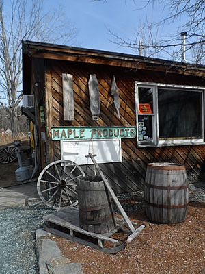
Sugar shack in Thornton
|
||
|
||

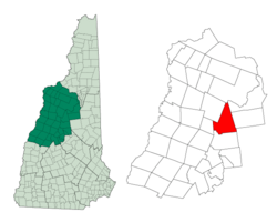
Location in Grafton County, New Hampshire
|
||
| Country | United States | |
| State | New Hampshire | |
| County | Grafton | |
| Incorporated | 1763 | |
| Villages |
|
|
| Area | ||
| • Total | 50.7 sq mi (131.3 km2) | |
| • Land | 50.1 sq mi (129.7 km2) | |
| • Water | 0.6 sq mi (1.6 km2) 1.19% | |
| Elevation | 617 ft (188 m) | |
| Population
(2020)
|
||
| • Total | 2,708 | |
| • Density | 54/sq mi (20.9/km2) | |
| Time zone | UTC-5 (Eastern) | |
| • Summer (DST) | UTC-4 (Eastern) | |
| ZIP code |
03285
|
|
| Area code(s) | 603 | |
| FIPS code | 33-76740 | |
| GNIS feature ID | 0873738 | |
Thornton is a small town in Grafton County, New Hampshire, United States. It is known for its beautiful natural surroundings. In 2020, about 2,708 people lived here. This was a bit more than the 2,490 people counted in 2010.
Contents
History of Thornton
Thornton became an official town on July 6, 1763. It was named after Doctor Matthew Thornton. He was an important person who signed the Declaration of Independence. This document declared America's freedom from Great Britain.
Geography and Nature
Thornton covers a total area of about 131.3 square kilometers (50.7 square miles). Most of this area, about 129.7 square kilometers (50.1 square miles), is land. The rest, 1.6 square kilometers (0.6 square miles), is water. Water makes up about 1.19% of the town's total area.
Rivers and Waterways
The Pemigewasset River flows through the western part of Thornton. Several smaller streams and rivers flow into the Pemigewasset. These include Eastman Brook, Mill Brook, Hubbard Brook, and the Mad River. All these waterways are part of the larger Merrimack River system.
Mountains and Forests
The highest point in Thornton is on the western side of Dickey Mountain. This spot is about 617 meters (2,024 feet) above sea level. The very top of Dickey Mountain, which is 833 meters (2,734 feet) high, is actually in the nearby town of Waterville Valley. A large part of the eastern side of Thornton is covered by the White Mountain National Forest. This forest is a protected area with lots of trees and wildlife.
Population and People
| Historical population | |||
|---|---|---|---|
| Census | Pop. | %± | |
| 1790 | 385 | — | |
| 1800 | 535 | 39.0% | |
| 1810 | 794 | 48.4% | |
| 1820 | 857 | 7.9% | |
| 1830 | 1,049 | 22.4% | |
| 1840 | 1,045 | −0.4% | |
| 1850 | 1,011 | −3.3% | |
| 1860 | 967 | −4.4% | |
| 1870 | 840 | −13.1% | |
| 1880 | 775 | −7.7% | |
| 1890 | 632 | −18.5% | |
| 1900 | 552 | −12.7% | |
| 1910 | 553 | 0.2% | |
| 1920 | 477 | −13.7% | |
| 1930 | 459 | −3.8% | |
| 1940 | 501 | 9.2% | |
| 1950 | 460 | −8.2% | |
| 1960 | 480 | 4.3% | |
| 1970 | 594 | 23.8% | |
| 1980 | 952 | 60.3% | |
| 1990 | 1,505 | 58.1% | |
| 2000 | 1,843 | 22.5% | |
| 2010 | 2,490 | 35.1% | |
| 2020 | 2,708 | 8.8% | |
| U.S. Decennial Census | |||
In 2000, there were 1,843 people living in Thornton. These people lived in 759 households, and 507 of these were families. The population density was about 14 people per square kilometer (36.6 per square mile). There were also 1,487 housing units, which are places where people can live.
Diversity in Thornton
Most people in Thornton are White, making up about 97.61% of the population. Other groups include African American (0.27%), Native American (0.11%), and Asian (0.27%). About 1.36% of the population identified as being from two or more races. People of Hispanic or Latino background made up 0.71% of the population.
Age and Households
About 29.6% of households had children under 18 living with them. Most households (56.5%) were married couples. The average household had 2.43 people, and the average family had 2.86 people.
The median age in Thornton was 38 years old. This means half the people were younger than 38 and half were older. About 22.4% of the population was under 18. About 12.4% were 65 or older.
Income and Economy
In 2000, the median income for a household in Thornton was $38,380 per year. For families, the median income was $45,172. The average income per person in the town was $18,478. About 9.5% of all people in Thornton lived below the poverty line. This included 13.5% of those under 18 and 3.0% of those 65 or older.
Famous People from Thornton
Thornton has been home to several notable individuals:
- Moses Cheney (1793–1875): He was an important person in the 1800s who worked to end slavery.
- Karl Drerup (1904–2000): A German-American artist known for his beautiful enamel artwork.
- Orison Swett Marden (1848–1924): He was a hotel owner and a famous author.
- Nevin S. Scrimshaw (1918–2013): A nutritionist who won the World Food Prize for his work on food and health.
See also
 In Spanish: Thornton (Nuevo Hampshire) para niños
 | Delilah Pierce |
 | Gordon Parks |
 | Augusta Savage |
 | Charles Ethan Porter |


