Mad River (Pemigewasset River tributary) facts for kids
Quick facts for kids Mad River |
|
|---|---|

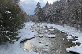
The Mad River at Upper Mad River Road bridge between Thornton and Waterville Valley
|
|
| Country | United States |
| State | New Hampshire |
| County | Grafton |
| Towns | Livermore, Waterville Valley, Thornton, Campton |
| Physical characteristics | |
| Main source | Greeley Ponds White Mountain National Forest 2,240 ft (680 m) 44°0′42″N 71°30′25″W / 44.01167°N 71.50694°W |
| River mouth | Pemigewasset River Campton 543 ft (166 m) 43°50′20″N 71°39′6″W / 43.83889°N 71.65167°W |
| Length | 17.9 mi (28.8 km) |
| Basin features | |
| Tributaries |
|
The Mad River is a beautiful river, about 17.9 miles (28.8 kilometers) long, located in the White Mountains of New Hampshire in the United States. It's like a smaller stream that flows into a bigger one, called the Pemigewasset River. The water from the Mad River eventually joins the Merrimack River, which means it's part of the huge area of land that drains into the Merrimack. This entire area is known as the watershed.
Contents
Exploring the Mad River's Journey
The Mad River starts its journey in a special place called the Greeley Ponds. These ponds are found in Mad River Notch, which is like a natural gap or mountain pass between two mountains. To the west is Mount Osceola, and to the east is Mount Kancamagus. This starting point is in the town of Livermore.
From Ponds to Valleys
From the Greeley Ponds, the river flows south. A hiking path, the Greeley Pond Trail, follows alongside it. The river then reaches the town of Waterville Valley. Here, another stream called the West Branch joins the Mad River, adding more water to its flow.
Through Resorts and Rapids
After passing through the Waterville Valley Resort community, the Mad River continues its path. It flows southwest, rushing over many rocks and boulders, creating continuous rapids. It then enters a part of the town of Thornton.
Eventually, the river calms down and flows into Campton Pond, located in the town of Campton.
Reaching the Pemigewasset River
In Campton Upper Village, the Mad River flows over a small dam that helps generate electricity. After this, it goes over some small waterfalls. Finally, the river enters the flat, low-lying area next to the Pemigewasset River, known as a floodplain. The Mad River then joins the Pemigewasset River near Interstate 93.
For most of its length after leaving Waterville Valley, the Mad River flows alongside New Hampshire Route 49. This makes it easy for people to see and enjoy the river as they drive.
 | Sharif Bey |
 | Hale Woodruff |
 | Richmond Barthé |
 | Purvis Young |


