
Campton, New Hampshire facts for kids
Quick facts for kids
Campton, New Hampshire
|
||
|---|---|---|
|
Town
|
||

NH 175 in Campton Upper Village
|
||
|
||

Location in Grafton County, New Hampshire
|
||
| Country | United States | |
| State | New Hampshire | |
| County | Grafton | |
| Incorporated | 1767 | |
| Villages |
|
|
| Area | ||
| • Total | 52.5 sq mi (136.1 km2) | |
| • Land | 51.9 sq mi (134.3 km2) | |
| • Water | 0.7 sq mi (1.8 km2) 1.33% | |
| Elevation | 676 ft (206 m) | |
| Population
(2020)
|
||
| • Total | 3,343 | |
| • Density | 64/sq mi (24.9/km2) | |
| Time zone | UTC-5 (Eastern) | |
| • Summer (DST) | UTC-4 (Eastern) | |
| ZIP code |
03223
|
|
| Area code(s) | 603 | |
| FIPS code | 33-08660 | |
| GNIS feature ID | 0873556 | |

Campton is a small town in Grafton County, New Hampshire, in the United States. In 2020, about 3,343 people lived there. Campton is known for its beautiful natural areas. These include Blair State Forest and Livermore Falls State Forest. The town is in the foothills of the White Mountains. Parts of the White Mountain National Forest are also nearby. Campton has several small communities within it, like Blair and West Campton.
Contents
History of Campton
Early Settlement and Naming
In 1761, Governor Benning Wentworth gave land for Campton and a nearby town called Rumney. A person named Jabez Spencer from Connecticut was given this land. Settlers started arriving around 1765. Two families, named Fox and Taylor, were among the first to live here.
However, Captain Spencer died before he could meet the rules for the land grant. These rules said that 50 families had to settle there. Each family also had to farm a certain amount of land. So, in 1767, a new grant was given by Governor John Wentworth. Campton got its name because the first people who owned the land set up a camp here. They used this camp while they were measuring the two towns.
Farming and Early Industries
Even though the land in Campton was hilly and rocky, farmers found good soil. This soil was in the flat areas along the rivers, which were great for growing crops. By 1859, about 1,439 people lived in Campton.
At that time, the town had several important businesses. There was a sawmill to cut wood and a gristmill to grind grain. There was also a tannery that made leather. A shop that built carriages was also busy.
Famous Covered Bridges
Campton is also home to three historic covered bridges. One of these is the Blair Bridge. It is about 292 feet long. This makes it the second longest covered bridge completely within New Hampshire.
-
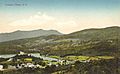
Campton village around 1910
-
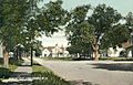
Main Street in 1908
-
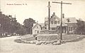
A Watering trough in 1916
-
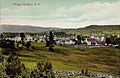
The village around 1910


Geography of Campton

Campton covers a total area of about 136.1 square kilometers (52.6 square miles). Most of this area is land, about 134.3 square kilometers (51.9 square miles). The rest, about 1.8 square kilometers (0.7 square miles), is water. This means water makes up about 1.33% of the town's total area.
The highest point in Campton is Mount Weetamoo. It stands about 2,548 feet (777 meters) above sea level. The town's water flows into the Pemigewasset River. Other smaller rivers and streams, like the Mad River and Beebe River, also flow through Campton. All these waters eventually join the Merrimack River.
Several important roads pass through Campton. These include Interstate 93, U.S. Route 3, New Hampshire Route 49, and New Hampshire Route 175. These roads help people travel to and from the town.
Population Changes
| Historical population | |||
|---|---|---|---|
| Census | Pop. | %± | |
| 1790 | 395 | — | |
| 1800 | 635 | 60.8% | |
| 1810 | 873 | 37.5% | |
| 1820 | 1,047 | 19.9% | |
| 1830 | 1,313 | 25.4% | |
| 1840 | 1,513 | 15.2% | |
| 1850 | 1,439 | −4.9% | |
| 1860 | 1,320 | −8.3% | |
| 1870 | 1,226 | −7.1% | |
| 1880 | 1,163 | −5.1% | |
| 1890 | 982 | −15.6% | |
| 1900 | 999 | 1.7% | |
| 1910 | 845 | −15.4% | |
| 1920 | 1,028 | 21.7% | |
| 1930 | 1,184 | 15.2% | |
| 1940 | 1,130 | −4.6% | |
| 1950 | 1,149 | 1.7% | |
| 1960 | 1,058 | −7.9% | |
| 1970 | 1,171 | 10.7% | |
| 1980 | 1,694 | 44.7% | |
| 1990 | 2,377 | 40.3% | |
| 2000 | 2,719 | 14.4% | |
| 2010 | 3,333 | 22.6% | |
| 2020 | 3,343 | 0.3% | |
| U.S. Decennial Census | |||
The population of Campton has changed quite a bit over the years. In 1790, there were only 395 people living there. The number of people grew steadily for many years. By 1840, the population reached over 1,500.
After that, the population went down for a while. It dropped to under 1,000 people by 1890. However, in the 20th century, the population started to grow again. By 2020, Campton had 3,343 residents. This shows that more people are choosing to live in this New Hampshire town.
Notable People from Campton
Campton has been home to several interesting people:
- Henry W. Blair (1834–1920) - He was a US congressman and senator.
- Chris Devlin-Young (born 1961) - A well-known ski racer.
- Arthur Livermore (1766–1853) - He also served as a US congressman.
- Sylvester Marsh (1803–1884) - He built the famous Mount Washington Cog Railway.
Places to Visit
- Blair Bridge (built in 1829, rebuilt in 1870) - A historic covered bridge.
- Town House (built in 1855) - This building is now home to the Campton Historical Society.
See also
 In Spanish: Campton (Nuevo Hampshire) para niños
