
Livermore, New Hampshire facts for kids
Quick facts for kids
Livermore, New Hampshire
|
|
|---|---|

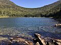
East Pond in the western part of Livermore
|
|

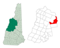
Location in Grafton County, New Hampshire
|
|
| Country | United States |
| State | New Hampshire |
| County | Grafton |
| Area | |
| • Total | 63.9 sq mi (165.6 km2) |
| • Land | 63.8 sq mi (165.2 km2) |
| • Water | 0.2 sq mi (0.4 km2) 0.26% |
| Elevation | 1,264 ft (385 m) |
| Population
(2020)
|
|
| • Total | 2 |
| • Density | 0.03/sq mi (0.01/km2) |
| Time zone | UTC-5 (Eastern) |
| • Summer (DST) | UTC-4 (Eastern) |
| Area code(s) | 603 |
| FIPS code | 33-009-42820 |
| GNIS feature ID | 873650 |
Livermore is a special place in Grafton County, New Hampshire, United States. It's known as an "unincorporated civil township" and a "ghost town." This means it's a type of local area that doesn't have its own official town government, and almost no one lives there anymore.
Livermore was once a busy logging town. People lived and worked there in the late 1800s and early 1900s. The old village site is about 16 miles west of North Conway. You can reach it by taking the U.S. Forest Service Sawyer River Road off U.S. Route 302.
The Saunders family, especially Daniel Saunders Jr. and Charles W. Saunders, started the logging business here. The town got its name from Samuel Livermore. He was a United States senator and the grandfather of Daniel Saunders' wife. In 2020, only two people were reported to be living in Livermore.
Contents
Exploring Livermore's Geography
Livermore covers a total area of about 165.6 square kilometers (64 square miles). Most of this land, about 165.2 square kilometers, is dry land. Only a small part, 0.4 square kilometers, is water. A huge part of Livermore, almost 99.7%, is part of the White Mountain National Forest.
Neighboring Towns and Natural Features
To the south of Livermore is Waterville Valley. To the north and west, you'll find Lincoln and a small part of Bethlehem. To the east are Hart's Location, Bartlett, and the northwest corner of Albany.
The old village of Livermore sits at an elevation of about 1,264 feet (385 meters). This spot is a quarter-mile from the eastern border near Hart's Location.
Unique Boundaries and Wilderness
Livermore is a long, narrow area shaped a bit like a crescent moon. Livermore and Lincoln cover a large area of forests that used to be called the "Pemigewasset Wilderness." Part of this wilderness is now protected within the WMNF.
The original border between Livermore and Lincoln caused problems. It didn't follow natural lines like mountain ridges. This led to arguments about who owned which trees. It was also hard to move cut timber over the high ridges.
Eventually, the New Hampshire government changed the town boundary. The new line follows the ridge crests. The Lincoln part includes land drained by the East Branch of the Pemigewasset River. The Livermore part includes land drained by other rivers.
This new boundary created a strange result: a small piece of Livermore is separate from the rest of the town. This small area is about 4.8 miles away from the main part of Livermore. Since all this land is now part of the White Mountain National Forest, this old boundary issue doesn't cause problems anymore.
Mountain Peaks and Roads
The curving northwestern border of Livermore follows the high ground between different river systems. Important mountains along this border include Mount Bemis (3,706 feet), Mount Lowell (3,743 feet), and Mount Carrigain. Mount Carrigain is the highest point in Livermore, reaching 4,700 feet (1,433 meters). Other peaks are Mount Kancamagus (3,728 feet) and Mount Osceola (4,326 feet).
Two main roads cross Livermore. The Kancamagus Highway (New Hampshire Route 112) crosses Kancamagus Pass (2,855 feet) on the Lincoln/Livermore border. It then goes through several miles of southeastern Livermore. The Tripoli Road, which is often closed in winter, crosses the southwest corner of the township. Neither of these roads passes close to the site of the old Livermore village.
Livermore's Changing Population
| Historical population | |||
|---|---|---|---|
| Census | Pop. | %± | |
| 1880 | 103 | — | |
| 1890 | 155 | 50.5% | |
| 1900 | 191 | 23.2% | |
| 1910 | 64 | −66.5% | |
| 1920 | 98 | 53.1% | |
| 1930 | 23 | −76.5% | |
| 1940 | 4 | −82.6% | |
| 2000 | 3 | — | |
| 2010 | 0 | −100.0% | |
| 2020 | 2 | — | |
| U.S. Decennial Census | |||
In 2020, the official count showed only two people living in Livermore.
The table next to this section shows how Livermore's population has changed over the years. It's interesting to see how the numbers went up and down. Livermore was a logging town, and many workers only stayed for the winter logging season. This made it hard to get an exact count of how many people truly lived there at any given time.
A Timeline of Livermore's History
Livermore has a fascinating history, mostly tied to its logging industry. Here's a look at some key events:
The Early Years and Logging Boom
- 1874: The Saunders family started the Grafton County Lumber Co.
- 1875: The Sawyer River Railroad company was created.
- 1876: Livermore officially became a town. The first mill was built but burned down that same year.
- 1877: Construction began on the Sawyer River Railroad to help with logging.
- 1880: A smallpox outbreak caused the deaths of six townspeople.
- 1881: Livermore got its own post office.
- 1885: The town reported having one school with 28 students.
- 1890: Records show that George P. James took over ownership of the mill from the Saunders family.
- 1891: Charles Saunders passed away. His brother Daniel and Daniel's son Charles G. Saunders continued to run the logging business.
- 1895: George P. James sold his share of Livermore back to the Saunders family, specifically Charles G. Saunders.
- 1896: A map from this year showed the railroad and twelve buildings where people lived.
- 1898: Telephone service arrived in Livermore.
Changes and Challenges
- 1901: More than half of Livermore's land was added to the town of Lincoln by the state government.
- 1910: A fire tower was built on top of Mount Carrigain.
- 1912: C. G. Saunders mortgaged the Livermore Mills to Gideon M. Sutherland.
- 1918: C. G. Saunders died. His three sisters inherited most of his property. Clinton I. Nash, an officer for the Saunders' businesses, took over running the mill.
- 1919: A big fire destroyed the Livermore Mills.
- 1920: The original train engine went off its tracks and fell into the Sawyer River. It was later replaced.
- 1922: A new, rebuilt mill was finished.
- 1924: A new school was completed. It had two teachers for about 20 students.
- 1927: A big storm in November caused a lot of damage. The mill was badly hurt, and a large part of the railroad tracks was washed away.
The End of the Logging Town
- 1928: The last mill in Livermore closed down.
- 1929: Clinton Nash talked to the United States Forest Service about selling the Saunders sisters' land in Livermore to the Forest Service.
- 1931: The Livermore post office closed its doors.
- 1937: Almost all of Livermore's land, except for a 12-acre parcel, was sold to the Forest Service. This land became part of the White Mountain National Forest. The Saunders sisters kept their 12 acres and their mansion.
- 1944: The government auctioned off a two-story home, a boarding house, and the remaining sawmill equipment.
- 1947: The train engine was sold by the Forest Service.
- 1949: The last two people living in Livermore left town.
- 1951: Livermore officially stopped being a town by an act of the New Hampshire government. In the same year, Clinton Nash received the Saunders sisters' 12 acres.
- 1963: Clinton Nash sold his Livermore property, including the Saunders mansion, to Robert and Bessie Shackford from Conway.
- 1964: Clinton Nash passed away.
- 1965: Robert Shackford burned down the Saunders mansion. He was tired of people vandalizing and damaging the property.
- 1970s: A bill to have Lincoln take over Livermore was defeated in the State House.
Images for kids
-
East Pond in the western part of Livermore
-
Location of Livermore in Grafton County, New Hampshire
See also
 In Spanish: Livermore (Nuevo Hampshire) para niños
