Hart's Location, New Hampshire facts for kids
Quick facts for kids
Hart's Location, New Hampshire
|
|
|---|---|
|
Town
|
|

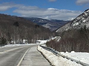
Looking north along U.S. Route 302 in Hart's Location
|
|

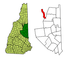
Location in Carroll County, New Hampshire
|
|
| Country | United States |
| State | New Hampshire |
| County | Carroll |
| Incorporated | 1795 |
| Area | |
| • Total | 18.78 sq mi (48.65 km2) |
| • Land | 18.68 sq mi (48.38 km2) |
| • Water | 0.10 sq mi (0.27 km2) 0.56% |
| Elevation | 897 ft (273 m) |
| Population
(2020)
|
|
| • Total | 68 |
| • Density | 4/sq mi (1.4/km2) |
| Time zone | UTC−5 (Eastern) |
| • Summer (DST) | UTC−4 (Eastern) |
| ZIP Code |
03812
|
| Area code | 603 |
| FIPS code | 33-34500 |
| GNIS feature ID | 0872015 |
Hart's Location is a small town in Carroll County, New Hampshire, United States. It's known for being one of the very first places to announce its voting results. This happens during the New Hampshire presidential primary and U.S. presidential elections. This tradition has been in place since 1948.
In 2020, the town had a population of 68 people. Hart's Location became an official town in 1795. It has a group of leaders called a board of selectmen. However, it relies on the nearby town of Bartlett and Carroll County for many services. The town is home to Crawford Notch State Park, which is famous for its beautiful mountains. The long-distance Appalachian Trail also passes through the town.
Contents
History of Hart's Location
Hart's Location got its name from Colonel John Hart of Portsmouth, New Hampshire. In 1772, the land was given to Thomas Chadbourne, also from Portsmouth.
Early Trails and Discoveries
Long ago, Native Americans used a trail that went up the Saco River valley through Crawford Notch. During the French and Indian Wars, many English captives were taken to Canada using this path. For a long time, this mountain pass in the White Mountains was not well known. Then, in 1771, a hunter named Timothy Nash discovered it while hunting moose. He told Governor John Wentworth about it.
The old Indian trail later became known as the Coös Road. A small public house, like an inn, was built there in 1793. It was later left empty.
The Willey Family Tragedy
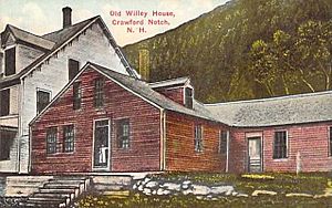
In 1825, Samuel Willey Jr. moved into the house with his wife, five children, and two helpers. On August 28, 1826, a huge storm hit. This storm caused a terrible landslide known as Willey's Slide. The entire family and their helpers died. They had left their home to find safety in a nearby shelter. Sadly, the shelter was destroyed, but their house remained untouched.
A large rock uphill split the landslide. The mud and rocks flowed around the house and then joined together again below it. When rescuers found the house, the door was open, and a bible lay open on a table. This sad event inspired a short story called "The Ambitious Guest" (1835) by Nathaniel Hawthorne. The mountain nearby was named Mount Willey in memory of the family. The house later became part of a bigger inn, but it burned down in 1898. Today, the spot is a state historic site.
Railroad Through the Notch
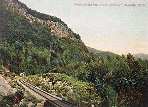
In 1875, the Portland and Ogdensburg Railroad finished building its train line through Crawford Notch. Passengers loved riding over the Frankenstein Trestle, which was 520 feet (158 m) long and 85 feet (26 m) above the ravine floor. They also crossed the Willey Brook Bridge, 400 feet (122 m) long and 94 feet (29 m) high. This train route later became part of the Mountain Division of the Maine Central Railroad. Today, the Conway Scenic Railroad still uses this historic route.
Geography of Hart's Location
Hart's Location covers a total area of about 18.8 square miles (48.6 km2). Most of this area is land, with a small amount of water.
Unique Shape and Location
The town of Hart's Location has a very unusual shape. It is about 11 miles (18 km) long but only about 1.5 miles (2.4 km) wide. Its borders are crooked because they follow the narrow Crawford Notch. The upper Saco River and U.S. Route 302 run through the middle of the town. The town is squeezed between steep mountains and tall cliffs.
This strange shape means that Hart's Location, which is part of Carroll County, is barely connected to the rest of its county. Coos County is right next to it on the east, and Grafton County is to the west.
Mountains and Waterfalls
The highest point in Hart's Location is 3,900 feet (1,200 m) above sea level. This spot is along the town's western border, near the top of Mount Willey, which is 4,285-foot (1,306 m) tall.
Arethusa Falls, New Hampshire's tallest waterfall, is located in the nearby area of Livermore. Many people enjoy hiking to the falls, and you can get there from U.S. Route 302 in Hart's Location. All the water in the town flows into the Saco River watershed.
In the winter, Hart's Location is a popular spot for ice climbing.
Population of Hart's Location
| Historical population | |||
|---|---|---|---|
| Census | Pop. | %± | |
| 1870 | 26 | — | |
| 1880 | 70 | 169.2% | |
| 1890 | 187 | 167.1% | |
| 1900 | 38 | −79.7% | |
| 1910 | 85 | 123.7% | |
| 1920 | 35 | −58.8% | |
| 1930 | 29 | −17.1% | |
| 1940 | 17 | −41.4% | |
| 1950 | 11 | −35.3% | |
| 1960 | 7 | −36.4% | |
| 1970 | 7 | 0.0% | |
| 1980 | 27 | 285.7% | |
| 1990 | 36 | 33.3% | |
| 2000 | 37 | 2.8% | |
| 2010 | 41 | 10.8% | |
| 2020 | 68 | 65.9% | |
| U.S. Decennial Census | |||
According to the 2000 census, 37 people lived in Hart's Location. There were 15 households and 10 families. Most of the people (97.30%) were White.
About one-third of the households had children under 18 living with them. Most households (66.7%) were married couples. The average household had about 2.5 people. The average family had about 3.1 people.
The population included people of all ages. About 24% were under 18, and 27% were 65 or older. The average age was 39 years old.
See also
 In Spanish: Hart's Location (Nuevo Hampshire) para niños
 | Bayard Rustin |
 | Jeannette Carter |
 | Jeremiah A. Brown |


