
Bartlett, New Hampshire facts for kids
Quick facts for kids
Bartlett, New Hampshire
|
|
|---|---|
|
Town
|
|

Bartlett Elementary School and Library
|
|
| Motto(s):
"In the Heart of the White Mountains"
|
|

Location in Carroll County, New Hampshire
|
|
| Country | United States |
| State | New Hampshire |
| County | Carroll |
| Incorporated | 1790 |
| Villages | |
| Area | |
| • Total | 75.2 sq mi (194.8 km2) |
| • Land | 74.8 sq mi (193.7 km2) |
| • Water | 0.4 sq mi (1.1 km2) 0.57% |
| Elevation | 671 ft (205 m) |
| Population
(2020)
|
|
| • Total | 3,200 |
| • Density | 43/sq mi (16.5/km2) |
| Time zone | UTC-5 (Eastern) |
| • Summer (DST) | UTC-4 (Eastern) |
| ZIP codes | |
| Area code(s) | 603 |
| FIPS code | 33-03700 |
| GNIS feature ID | 0873539 |
Bartlett is a town in Carroll County, New Hampshire, United States. It's a beautiful place located in the White Mountains. The town is surrounded by the large White Mountain National Forest.
In 2020, about 3,200 people lived in Bartlett. The town includes small communities like Glen, and parts of Kearsarge and Intervale. Bartlett is famous for fun places like Attitash Mountain Resort and the Story Land theme park.
The main part of Bartlett, where about 351 people live, is found where U.S. Route 302 meets Bear Notch Road.
Contents
Bartlett's History

Bartlett was settled after 1769 and officially became a town in 1790. It was named after Dr. Josiah Bartlett. He was a very important person from New Hampshire. Dr. Bartlett was one of the three people from New Hampshire who signed the Declaration of Independence. He also helped start the New Hampshire Medical Society in 1791.
In 1875, Bartlett became a "railroad town" when the Maine Central Railroad built its Mountain Division line through the area. This helped the town grow. Later, in 1954, Story Land, a fun theme park for young children, opened in Glen. The Attitash ski area opened in the 1960s, adding more fun for visitors.
A special building called the Bartlett Roundhouse in Bartlett village was added to the National Register of Historic Places in 2015. This means it's an important historical site.
Fun Things to Do in Bartlett
Bartlett is a popular place for visitors because of its amazing views of the White Mountains. Tourism is a big part of the town's economy.
Here are some fun things you can do:
- Skiing and Snowboarding: Attitash Mountain Resort is the sixth largest ski area in New Hampshire. You can also find trails for cross-country skiing at the Bear Notch Ski Touring area.
- Covered Bridge: The town has one charming covered bridge, which is a cool sight to see.
- Train Rides: The Conway Scenic Railroad operates a train from nearby North Conway to Bartlett. It's a great way to see the scenery in spring, summer, and fall.
- Theme Parks: Visit Story Land in Glen for a magical day, especially if you have younger siblings.
- Nature Walks: Explore places like Diana's Baths on Lucy Brook, which has beautiful waterfalls and pools.
Exploring Bartlett's Nature and Villages
Bartlett covers about 75 square miles (194.8 square kilometers). It has lots of natural beauty. The Saco River and its smaller branch, the Ellis River, flow through the town.
The highest point in Bartlett is Mount Tremont, which is about 3,371 feet (1,027 meters) tall. Other mountains nearby include Mount Parker and Bear Mountain.
Besides the main town center, Bartlett includes several smaller villages:
- Glen: This is where the famous Story Land amusement park is located.
- Intervale: A lovely resort community known for its peaceful atmosphere.
- Lower Bartlett: Located between Glen and Intervale, along the East Branch of the Saco River.
You can also find Goodrich Falls on the Ellis River in the northern part of town, right next to Route 16.
Who Lives in Bartlett?
In 2020, the population of Bartlett was 3,200 people. This was an increase from 2,788 people in 2010.
Many homes in Bartlett are used for vacations or recreation, especially during different seasons. The town is a mix of full-time residents and people who come to enjoy the mountains and attractions.
Getting Around Bartlett
There are a few main roads that help you travel through Bartlett:
- New Hampshire Route 16 (NH 16): This is the main road that goes north and south through Bartlett. It's also called the White Mountain Highway.
- New Hampshire Route 16A (NH 16A): This road runs next to NH 16 and helps you get to the resort areas in Intervale.
- U.S. Route 302 (US 302): This route comes into town from the west and goes through the main village of Bartlett. It then joins NH 16 and continues south.
Images for kids
-
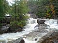
Diana's Baths on Lucy Brook
-
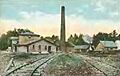
Kearsarge Peg Mill around 1910


See also
 In Spanish: Bartlett (Nuevo Hampshire) para niños
