
Bethlehem, New Hampshire facts for kids
Quick facts for kids
Bethlehem, New Hampshire
|
|
|---|---|
|
Town
|
|

Main street of Bethlehem, spring 2009
|
|
| Motto(s):
Star of the White Mountains
|
|

Location in Grafton County, New Hampshire
|
|
| Country | United States |
| State | New Hampshire |
| County | Grafton |
| Incorporated | 1799 |
| Villages |
|
| Area | |
| • Total | 91.0 sq mi (235.6 km2) |
| • Land | 90.6 sq mi (234.7 km2) |
| • Water | 0.3 sq mi (0.9 km2) 0.39% |
| Elevation | 1,426 ft (435 m) |
| Population
(2020)
|
|
| • Total | 2,484 |
| • Density | 27/sq mi (10.6/km2) |
| Time zone | UTC-5 (Eastern) |
| • Summer (DST) | UTC-4 (Eastern) |
| ZIP code |
03574
|
| Area code(s) | 603 |
| FIPS code | 33-05460 |
| GNIS feature ID | 0873546 |
Bethlehem is a town located on a hillside in Grafton County, New Hampshire, United States. In 2020, about 2,484 people lived here. The town is home to Cushman and Strawberry Hill state forests. The eastern part of Bethlehem is inside the White Mountain National Forest. A small part of the famous Appalachian Trail also runs through the southern area of the town.
The main village of Bethlehem is called the Bethlehem census-designated place (CDP). About 826 people lived there in 2020. It is found where U.S. Route 302 and New Hampshire Route 142 meet. The town also includes smaller villages like Maplewood and Pierce Bridge.
Contents
History of Bethlehem
Early Days and Naming
Bethlehem was first given the name "Lloyd's Hills" in 1774 by Governor John Wentworth. It was named after James Lloyd from Boston. This was the last area granted by the province in New Hampshire. After the American Revolutionary War, the original paperwork for the land was lost. This made it hard for people to settle there until 1787, when the first permanent homes were built.
The town was renamed "Bethlehem" on December 27, 1799. The new name was chosen on Christmas Day. This change removed the old name that honored James Lloyd, who was a Loyalist (someone who supported the British during the American Revolution). At that time, only 33 families lived in Bethlehem, and farming was their main way of life.
Growth and Tourism
By 1850, the town's population grew to 950 people. Bethlehem had a gristmill (for grinding grain), five large sawmills (for cutting wood), and two starch factories. In 1867, the railroad arrived at Bethlehem Junction. This brought many tourists from places like Boston and New York. Many came because the air in Bethlehem had a low pollen count, which was thought to help with breathing problems. Others were drawn by the beautiful paintings of the White Mountain artists.
Bethlehem was close to Mount Washington and other attractions in the White Mountains. Because of this, it became a popular vacation spot for rich and famous people during the Gilded Age (a time of great wealth and growth in the late 1800s).
Grand Hotels and Famous Visitors
In 1873, a building boom started, and Governor Henry Howard of Rhode Island built the Howard House hotel. Eventually, more than 30 hotels lined the streets of Bethlehem. Seven trains arrived every day, some coming directly from Grand Central Terminal in New York City. These trains stopped at Bethlehem's five train stations.
Many important people visited Bethlehem, including Presidents Grant, Hayes, Roosevelt, Taft, and Harding. Famous writers like Thornton Burgess and poet Robert Frost also enjoyed their time there. Visitors could walk along a two-and-a-half-mile raised boardwalk on Main Street, take carriage rides in the countryside, play croquet, or simply relax on the large porches of the hotels.
Wealthy families also built big summer "cottages" in Bethlehem, including the family of Frank Winfield Woolworth, who founded the Woolworth stores. Starting in 1887, an annual Coaching Parade was held. People would decorate their horse-drawn carriages in fancy ways and win prizes. Some decorations cost as much as $5,000! Phineas T. Barnum, a famous showman, even called it "the Second Greatest Show on Earth."
Changes Over Time
The invention of the automobile led to the decline of the grand hotels. Tourists could now drive to places beyond where the trains went. Around 1916, Jewish families began to visit Bethlehem, often seeking relief from hay fever symptoms. An organization called the Hebrew Hay Fever Relief Association was even formed in the 1920s. Today, Bethlehem has a noticeable Jewish community and several synagogues, a lasting result of its history as a hay fever relief spot.
World War II gave the hotels a short boost, as people chose to vacation closer to home instead of going to war-torn Europe. However, by the 1950s, fewer people were staying in the hotels. Many closed down and were torn down.
Today, Bethlehem is famous for its special Christmas postal cancellation stamp. Every year, people from all over the world send their Christmas cards to the Bethlehem post office to have them postmarked with this unique stamp. In 2000, the post office handled 56,000 Christmas cards!
Landfill Discussion
Since the 1980s, there has been an ongoing discussion in Bethlehem about a landfill (a place where trash is buried). A company bought the town dump and created a landfill there. The company has tried to make the landfill bigger. Some town residents have tried to stop the landfill from expanding, leading to disagreements.
Geography and Climate
Land and Water
Bethlehem covers a total area of about 235.6 square kilometers (about 91 square miles). Most of this area, 234.7 square kilometers (90.6 square miles), is land. Only 0.9 square kilometers (0.35 square miles) is water, which is about 0.39% of the town's total area.
Several rivers flow through Bethlehem, including the Ammonoosuc, Gale, Zealand, and Little rivers. There are also smaller streams like Tuttle, Baker, and Haystack brooks.
Mountains and Watersheds
To the south of the town center, you can find Mount Cleveland, which is 2,397 feet (731 meters) tall, and Mount Agassiz, which is 2,378 feet (725 meters) tall. The town's borders also include several of New Hampshire's famous 4,000-footers (mountains over 4,000 feet high). These include North Twin Mountain, which is the highest point in Bethlehem at 4,761 feet (1,451 meters). Other tall mountains here are Mount Hale, Mount Tom, Mount Field, and Mount Willey.
Most of Bethlehem is part of the Connecticut River watershed. This means that water from this area eventually flows into the Connecticut River. A very small part of the southeastern corner of the town is in the Merrimack River watershed, and an even smaller part on the eastern side of the Willey Range is in the Saco River watershed.
| Climate data for Bethlehem 2, NH (1991–2020 normals, extremes 1893–1991) | |||||||||||||
|---|---|---|---|---|---|---|---|---|---|---|---|---|---|
| Month | Jan | Feb | Mar | Apr | May | Jun | Jul | Aug | Sep | Oct | Nov | Dec | Year |
| Record high °F (°C) | 65 (18) |
61 (16) |
80 (27) |
89 (32) |
91 (33) |
94 (34) |
96 (36) |
95 (35) |
90 (32) |
85 (29) |
75 (24) |
62 (17) |
96 (36) |
| Mean daily maximum °F (°C) | 27.8 (−2.3) |
30.4 (−0.9) |
39.7 (4.3) |
53.4 (11.9) |
67.4 (19.7) |
75.7 (24.3) |
80.2 (26.8) |
78.8 (26.0) |
71.7 (22.1) |
58.2 (14.6) |
44.7 (7.1) |
33.1 (0.6) |
55.1 (12.9) |
| Daily mean °F (°C) | 15.6 (−9.1) |
17.3 (−8.2) |
27.1 (−2.7) |
40.4 (4.7) |
53.2 (11.8) |
61.8 (16.6) |
66.4 (19.1) |
64.5 (18.1) |
56.8 (13.8) |
45.3 (7.4) |
34.1 (1.2) |
22.3 (−5.4) |
42.1 (5.6) |
| Mean daily minimum °F (°C) | 3.4 (−15.9) |
4.1 (−15.5) |
14.4 (−9.8) |
27.3 (−2.6) |
39.0 (3.9) |
47.9 (8.8) |
52.7 (11.5) |
50.2 (10.1) |
42.0 (5.6) |
32.4 (0.2) |
23.5 (−4.7) |
11.6 (−11.3) |
29.0 (−1.6) |
| Record low °F (°C) | −36 (−38) |
−34 (−37) |
−22 (−30) |
−4 (−20) |
20 (−7) |
28 (−2) |
36 (2) |
33 (1) |
22 (−6) |
8 (−13) |
−9 (−23) |
−34 (−37) |
−36 (−38) |
| Average precipitation inches (mm) | 2.59 (66) |
2.04 (52) |
2.56 (65) |
3.15 (80) |
3.69 (94) |
4.24 (108) |
4.63 (118) |
4.16 (106) |
3.58 (91) |
3.97 (101) |
3.04 (77) |
3.34 (85) |
40.99 (1,041) |
| Average snowfall inches (cm) | 21.3 (54) |
21.5 (55) |
16.7 (42) |
5.4 (14) |
0.4 (1.0) |
0 (0) |
0 (0) |
0 (0) |
0 (0) |
1.6 (4.1) |
7.1 (18) |
26.9 (68) |
100.9 (256) |
| Average precipitation days (≥ 0.01 in) | 16.0 | 12.1 | 13.8 | 12.6 | 15.5 | 16.6 | 14.7 | 13.0 | 11.4 | 14.1 | 13.5 | 15.7 | 169.0 |
| Average snowy days (≥ 0.01 in) | 12.8 | 9.8 | 8.4 | 3.0 | 0.2 | 0 | 0 | 0 | 0 | 0.9 | 4.8 | 11.1 | 51.0 |
| Source: NOAA / Western Regional Climate Center | |||||||||||||
Population Information
| Historical population | |||
|---|---|---|---|
| Census | Pop. | %± | |
| 1800 | 171 | — | |
| 1810 | 422 | 146.8% | |
| 1820 | 467 | 10.7% | |
| 1830 | 665 | 42.4% | |
| 1840 | 779 | 17.1% | |
| 1850 | 950 | 22.0% | |
| 1860 | 896 | −5.7% | |
| 1870 | 998 | 11.4% | |
| 1880 | 1,400 | 40.3% | |
| 1890 | 1,267 | −9.5% | |
| 1900 | 1,261 | −0.5% | |
| 1910 | 1,201 | −4.8% | |
| 1920 | 866 | −27.9% | |
| 1930 | 872 | 0.7% | |
| 1940 | 935 | 7.2% | |
| 1950 | 882 | −5.7% | |
| 1960 | 898 | 1.8% | |
| 1970 | 1,142 | 27.2% | |
| 1980 | 1,784 | 56.2% | |
| 1990 | 2,033 | 14.0% | |
| 2000 | 2,199 | 8.2% | |
| 2010 | 2,526 | 14.9% | |
| 2020 | 2,484 | −1.7% | |
| U.S. Decennial Census | |||
According to the census of 2010, there were 2,526 people living in Bethlehem. There were 1,103 households (groups of people living together) and 698 families. About 27.3% of the households had children under 18 living with them.
Most of the people in Bethlehem were white (97.2%). A small number were African American, Native American, or Asian. About 1.7% of the population identified as Hispanic or Latino.
The average age of people in Bethlehem was 45.5 years old. About 20.9% of the population was under 18 years old.
Places to Visit
- Bethlehem Heritage Society Museum
- The Colonial Theatre
- The Rocks Estate
Images for kids
-
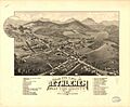
Panoramic Map of Bethlehem in 1883
-
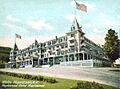
The Maplewood Hotel c. 1905
-
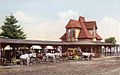
Railway Station c. 1905
-
Main Street in 1919
-
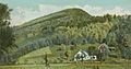
Mount Agassiz in 1906
-

Bird's-eye view in 1909
-
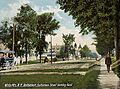
Horse Trolley
-
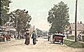
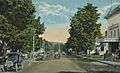
Main Street in 1907
-
The Colonial Theatre c. 1920


See also
 In Spanish: Bethlehem (Nuevo Hampshire) para niños
