Mount Hale (New Hampshire) facts for kids
Quick facts for kids Mount Hale |
|
|---|---|

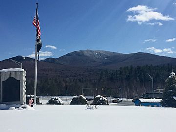
View of Mt. Hale from village of Twin Mountain
|
|
| Highest point | |
| Elevation | 4,054 ft (1,236 m) |
| Prominence | 614 ft (187 m) |
| Listing | White Mountain 4000-Footers |
| Geography | |
| Location | Grafton County, New Hampshire, U.S. |
| Parent range | Twin Range |
| Topo map | USGS South Twin Mountain |
Mount Hale is a mountain found in Grafton County, New Hampshire, in the United States. It's part of the Twin Range within the larger White Mountains. The mountain gets its name from Reverend Edward Everett Hale (1822–1909), a famous writer and minister.
About Mount Hale
Mount Hale stands tall at 4,054 feet (about 1,236 meters) above sea level. It's one of the special mountains known as the "White Mountain 4000-Footers" in New Hampshire. These are peaks that are 4,000 feet or higher. Many hikers try to climb all of them!
Water Flowing from Mount Hale
Water from Mount Hale flows in different directions. On the western side, streams join the Little River. On the eastern side, water flows into the Zealand River. Both of these rivers eventually flow into the Ammonoosuc River. From there, the water travels into the Connecticut River, which is a very long river. Finally, it reaches the Long Island Sound in Connecticut, which is part of the Atlantic Ocean.
Hiking Trails
Mount Hale is a popular spot for hikers. There are several trails that lead to its summit. One major trail goes right over the peak. If you keep going on this trail, you can reach the Zealand Falls Hut. This hut is a place where hikers can rest or stay overnight. It is about 2.8 miles (4.5 kilometers) away from the summit of Mount Hale.
 | Audre Lorde |
 | John Berry Meachum |
 | Ferdinand Lee Barnett |

