Albany, New Hampshire facts for kids
Quick facts for kids
Albany, New Hampshire
|
|
|---|---|
|
Town
|
|

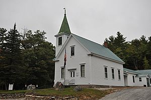
Albany Chapel, Museum, and Town Offices
|
|

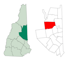
Location in Carroll County, New Hampshire
|
|
| Country | United States |
| State | New Hampshire |
| County | Carroll |
| Incorporated | 1833 |
| Villages |
|
| Area | |
| • Total | 75.8 sq mi (196.2 km2) |
| • Land | 75.1 sq mi (194.6 km2) |
| • Water | 0.6 sq mi (1.5 km2) 0.79% |
| Elevation | 680 ft (210 m) |
| Population
(2020)
|
|
| • Total | 759 |
| • Density | 10/sq mi (3.9/km2) |
| Time zone | UTC-5 (Eastern) |
| • Summer (DST) | UTC-4 (Eastern) |
| ZIP code |
03818
|
| Area code(s) | 603 |
| FIPS code | 33-00420 |
| GNIS feature ID | 0873526 |
Albany is a small town in Carroll County, New Hampshire, United States. In 2020, about 759 people lived there.
Most of Albany is located inside the beautiful White Mountain National Forest. This includes tall mountains like Mount Chocorua and Mount Paugus. Albany is also known as the gateway to the Mount Washington Valley.
A cool feature in Albany is a 120-foot (about 37-meter) covered bridge. It crosses the Swift River just north of the Kancamagus Highway. Albany is also home to the World Fellowship Center. This is a special camp and retreat center. It was started in 1941 by people who wanted to promote peace.
Contents
History of Albany
The area was first given a special paper, called a charter, in 1766. This was done by Governor Benning Wentworth. He named it "Burton" after General Jonathan Burton.
Later, in 1833, the town was officially formed and renamed "Albany". This happened when a railroad company, the New York Central Railroad, was created. This railroad connected New York City to Albany, New York.
Exploring Albany's Geography
Albany covers a total area of about 75.7 square miles (196.2 square kilometers). Most of this is land, about 75.1 square miles (194.6 square kilometers). A small part, about 0.6 square miles (1.5 square kilometers), is water.
The town has two main rivers: the Swift River in the north and the Chocorua River in the south. All the water in Albany eventually flows into the Saco River.
Mountains and Forests
Mount Chocorua is the highest point in Albany. It stands tall at 3,474 feet (1,059 meters). Mount Paugus is another high peak, reaching 3,201 feet (976 meters).
A huge part of Albany, about 85%, is within the White Mountain National Forest. This means lots of nature and outdoor spaces! Most homes and buildings are found in the southeastern part of town. They are often along New Hampshire Route 16.
Route 112, also known as the Kancamagus Highway, runs through Albany. It's a very popular road for scenic drives. It follows the Swift River and is almost entirely inside the national forest.
The old village of Passaconaway is along the Kancamagus Highway. It's now a popular spot for visitors to the national forest. Other places in Albany include Ferncroft and the former Paugus Mill site.
Nearby Towns
Albany shares its borders with several other towns:
- Bartlett (north)
- Hale's Location (northeast)
- Conway (east)
- Madison (southeast)
- Tamworth (south)
- Sandwich (southwest)
- Waterville Valley (west)
- Livermore (northwest)
People of Albany
| Historical population | |||
|---|---|---|---|
| Census | Pop. | %± | |
| 1840 | 406 | — | |
| 1850 | 455 | 12.1% | |
| 1860 | 430 | −5.5% | |
| 1870 | 339 | −21.2% | |
| 1880 | 361 | 6.5% | |
| 1890 | 377 | 4.4% | |
| 1900 | 210 | −44.3% | |
| 1910 | 289 | 37.6% | |
| 1920 | 170 | −41.2% | |
| 1930 | 96 | −43.5% | |
| 1940 | 131 | 36.5% | |
| 1950 | 154 | 17.6% | |
| 1960 | 146 | −5.2% | |
| 1970 | 259 | 77.4% | |
| 1980 | 383 | 47.9% | |
| 1990 | 536 | 39.9% | |
| 2000 | 654 | 22.0% | |
| 2010 | 735 | 12.4% | |
| 2020 | 759 | 3.3% | |
| U.S. Decennial Census | |||
In 2000, there were 654 people living in Albany. There were 262 households, which are groups of people living together. About 34.7% of these households had children under 18.
The population was spread out by age:
- 26.5% were under 18 years old.
- 6.1% were between 18 and 24.
- 36.7% were between 25 and 44.
- 22.8% were between 45 and 64.
- 8.0% were 65 years or older.
The average age in Albany was 37 years.
Getting Around Albany
Three main New Hampshire State Routes help people travel through Albany:
- NH 16: This is the main road through the town's central area. It's also known as the Chocorua Mountain Highway. It goes through the southeastern part of Albany.
- NH 112: This is the famous Kancamagus Highway. It's a beautiful road that connects Waterville Valley in the west to Conway in the east. It follows the Swift River.
- NH 113: This route enters Albany from Madison in the south. For a short distance, it shares the road with NH 16 before heading east into Conway.
See also
 In Spanish: Albany (Nuevo Hampshire) para niños
 | John T. Biggers |
 | Thomas Blackshear |
 | Mark Bradford |
 | Beverly Buchanan |

