Mount Chocorua facts for kids
Quick facts for kids Mount Chocorua |
|
|---|---|
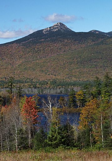
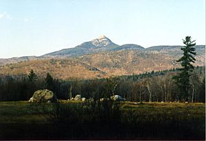
Mount Chocorua and Chocorua Lake
|
|
| Highest point | |
| Elevation | 3,480 ft (1,060 m) |
| Prominence | 1,240 ft (380 m) |
| Geography | |
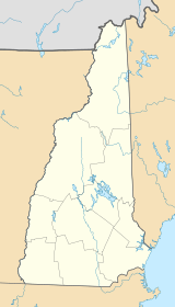
| Location | Albany, New Hampshire, U.S. |
| Parent range | Sandwich Range, White Mountains |
| Topo map | USGS Mount Chocorua |
| Climbing | |
| Easiest route | Piper Trail Champney Falls Trail Liberty Trail |
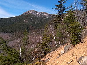
Mount Chocorua is a famous mountain in the White Mountains of New Hampshire. It stands about 3,490 feet (1,064 meters) tall. Even though it's not the tallest mountain, it's known for its rough, rocky look and amazing views. You can see beautiful lakes, other mountains, and thick forests from its top.
Mount Chocorua's bare, rocky peak is easy to spot from far away. Many people in central New Hampshire and western Maine can see it. Lots of hiking trails lead up the mountain. The pretty Chocorua Lake is right to the south of it.
Contents
Where is Mount Chocorua Located?
Mount Chocorua is found in the town of Albany. It's the easternmost peak of the Sandwich Range, which is part of New Hampshire's White Mountain National Forest. The Sandwich Range is north of the Lakes Region and south of the Kancamagus Highway. This mountain range stretches about 30 miles (48 kilometers) from east to west.
Why is Mount Chocorua So Famous?
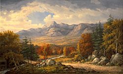
Chocorua's top looks like a beautiful rocky cone. Many people say it's one of the most photographed mountains in the world! The view from Chocorua Lake is especially famous. The lake often reflects the mountain, creating a stunning picture. This reflection was even chosen to represent the White Mountain National Forest on a special quarter coin. The U.S. Mint released this coin in 2013 as part of its "America the Beautiful" coin series.
The area around Chocorua Lake is protected by a group called the Chocorua Lake Conservancy. They work to keep the natural beauty of the basin safe.
Exploring Mount Chocorua: Hiking Trails
Even though Mount Chocorua is under 3,500 feet (1,067 meters) high, its bare and rocky top offers fantastic views in every direction. There are many trails to climb the mountain. These trails can get very busy, especially during the summer.
Some of the most popular trails include:
- The Piper Trail: This trail is about 4.2 miles (6.8 kilometers) long one way from the east.
- The Champney Falls Trail: This trail starts from the north.
- The Liberty Trail: This trail begins from the southwest.
The Chocorua Mountain Club helps take care of some of the trails. This group of volunteers has been working on the trails since 1908. They maintain trails on the southeastern part of Mount Chocorua and on Mount Paugus, which is just west of Chocorua.
Popular Hiking Paths on Mount Chocorua
Here are some of the hiking trails on Mount Chocorua, listed in a clockwise direction starting from the southwest side:
- Liberty Trail
- Brook Trail
- Bolles Trail
- Bee Line Trail
- Champney Falls Trail
- Middle Sister Trail
- Carter Ledge Trail
- Nickerson Ledge Trail
- Piper Trail
- Weetamoo Trail
- Hammond Trail
The Legend of Chief Chocorua
There's an old story about a Native American chief or prophet named Chocorua. The legend says he lived near the mountain when the first white settlers arrived, around the 1720s. However, there are no official records to prove his life story.
The most common version of the legend comes from a short story by Lydia Maria Child. It says that Chocorua was friendly with the settlers, especially the Campbell family, who lived in the valley now called Tamworth.
One day, Chocorua had to leave and asked the Campbell family to look after his son. Sadly, the boy found and drank some poison that Mr. Campbell had made to get rid of foxes. When Chocorua returned, he found his son had died. Filled with sadness and anger, Chocorua promised to get revenge on the family.
Soon after, Mr. Campbell came home to find his wife and children had been killed. He believed Chocorua was responsible and chased him up the mountain. The story says Campbell shot Chocorua. As Chocorua was dying, he supposedly shouted a curse on the white settlers before jumping from the mountain's peak.
Other Versions of the Chocorua Story
There are at least three other versions of the legend:
- Some say Chocorua simply fell from a high rock on the mountain while he was hunting.
- Another story suggests that white settlers chased Chocorua up the mountain after a conflict, and he jumped to his death.
- A third version claims that all the white settlers chased him with guns, pitchforks, and torches. As Chocorua reached the top, the settlers decided to burn the trees. This fire supposedly burned away the topsoil of the last 1,270 feet (387 meters) of the mountain. As the flames got closer, Chocorua cursed the white men and then jumped to his death.
What Was Chocorua's Curse?
No one knows for sure if Chocorua really cursed anyone, or what his exact words were. But one reported version of the curse goes like this: "May the Great Spirit curse you when he speaks in the clouds and his words are fire! Lightning blast your crops! Wind and fire destroy your homes! The Evil One breathe death on your cattle! Panthers howl and wolves fatten on your bones!"
Another version of the curse appeared in Lydia Maria Child's story "Chocorua's Curse" from 1830: "A curse upon ye, white men! May the Great Spirit curse ye when he speaks in the clouds, and his words are fire! Chocorua had a son — and ye killed him while the sky looked bright! Lightning, blast your crops! Wind and fire destroy your dwellings! The Evil Spirit breathe death upon your cattle! Your graves lie in the war path of the Indian! Panthers howl, and wolves fatten over your bones! Chocorua goes to the Great Spirit — his curse stays with the white men!"
You can find the legend of Chocorua mentioned on a New Hampshire historical marker (number 31) along New Hampshire Route 16 in Tamworth.
Images for kids
 | Aaron Henry |
 | T. R. M. Howard |
 | Jesse Jackson |


