Sandwich Range facts for kids
Quick facts for kids Sandwich Range |
|
|---|---|

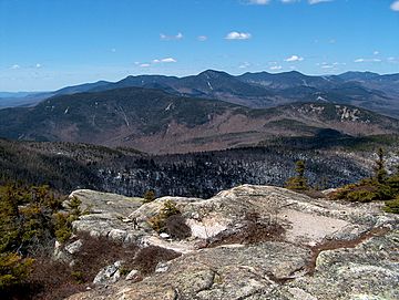
The Sandwich Range as seen looking west from Mount Chocorua. Summits include Mount Paugus (mid-foreground), Mount Whiteface (horizon mid-left), Mount Passaconaway (horizon center), and Mount Tripyramid (horizon mid-right).
|
|
| Highest point | |
| Peak | Mount Tripyramid |
| Elevation | 4,170 ft (1,270 m) |
| Geography | |
| Country | United States |
| State | New Hampshire |
| Parent range | White Mountains, Appalachian Mountains |
The Sandwich Range is a group of mountains in the White Mountains of New Hampshire, United States. It sits north of the Lakes Region and south of the Kancamagus Highway. Even though these mountains are not super tall, they are very rugged. They offer amazing views of nearby lakes, other mountains, and thick forests.
The Sandwich Range stretches about 30 miles (48 km) from east to west. It goes from Conway, New Hampshire near the Saco River to Campton by the Pemigewasset River. The Kancamagus Highway runs along the northern side of these mountains. It connects Conway to North Woodstock. The tallest mountain in this range is Mount Tripyramid. It stands 4,170 feet (1,270 m) high.
Water from the eastern part of the range flows into the Saco River. This river then empties into the Atlantic Ocean at Saco, Maine. Water from the western part goes into the East Branch Pemigewasset River and Mad River. These rivers join the Pemigewasset, then the Merrimack, and finally reach the sea at Newburyport, Massachusetts.
The range shares its name with the town of Sandwich. This town is located at the western end of the mountains. To the south, you can find the Ossipee Mountains. These mountains include an ancient volcanic ring dike from the Mt. Shaw area.
Explore the Main Peaks of the Sandwich Range
The Sandwich Range has several important mountain peaks. Here are some of the most well-known summits:
- Mount Chocorua 3,490 ft (1,060 m)
- Mount Kancamagus 3,763 ft (1,147 m)
- Mount Passaconaway 4,043 ft (1,232 m)
- Mount Paugus 3,198 ft (975 m)
- Mount Tripyramid 4,170 ft (1,270 m)
- Mount Whiteface 4,020 ft (1,230 m)
- Mount Wonalancet 2,760 ft (840 m)
- Sandwich Mountain 3,993 ft (1,217 m)
- The Sleepers 3,880 ft (1,180 m)
Some of these peaks are part of a special list. The Appalachian Mountain Club keeps a list of "Four-thousand footers" in New Hampshire. These are mountains that are at least 4,000 feet tall.
Discover the Sandwich Range Wilderness Area
The Sandwich Range Wilderness was created in 1984. Its purpose is to protect a rugged part of the White Mountains. This area is part of the National Wilderness Preservation System. It covers 35,303-acre (142.87 km2) of land.
This wilderness area is located entirely within the White Mountain National Forest. The U.S. Forest Service manages and protects it. The wilderness area includes several mountains from west to east. These are Sandwich Mountain, Mount Tripyramid, The Sleepers, Mount Whiteface, Mount Passaconaway, and Mount Paugus. Mount Kancamagus is just outside the wilderness to the west. Mount Chocorua is outside it to the east.
 | William M. Jackson |
 | Juan E. Gilbert |
 | Neil deGrasse Tyson |

