Mount Tripyramid (New Hampshire) facts for kids
Quick facts for kids North Tripyramid |
|
|---|---|

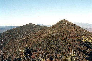
North and Middle Peaks, Mount Tripyramid
|
|
| Highest point | |
| Elevation | 4,160 ft (1,270 m) |
| Prominence | 1,320 ft (400 m) |
| Listing | New Hampshire 4000-footers |
| Geography | |
| Location | Grafton County, New Hampshire, U.S. |
| Parent range | Sandwich Range |
| Topo map | USGS Mount Tripyramid |
| Middle Tripyramid | |
|---|---|
| Highest point | |
| Elevation | 4,120 ft (1,260 m) |
| Prominence | 240 ft (73 m) |
| Listing | New Hampshire 4000-footers |
| South Tripyramid | |
|---|---|
| Highest point | |
| Elevation | 4,080 ft (1,240 m) |
| Prominence | 80 ft (24 m) |
Mount Tripyramid is a cool mountain found in Grafton County, New Hampshire. It's part of the Sandwich Range within the famous White Mountains. What makes it special are its three main peaks: North, Middle, and South. These peaks stretch along a ridge about a mile long. North Tripyramid is the tallest, standing at about 4,160 feet (1,268 meters) high!
Contents
Exploring Mount Tripyramid's Peaks
Mount Tripyramid isn't just one peak; it's a group of them. Besides the three main ones, there are smaller peaks nearby. Scaur Peak and The Fool Killer are to the northwest and northeast. To the southeast, you'll find The Sleepers.
The Three Main Peaks
- North Tripyramid: This is the highest peak at 4,160 feet (1,268 meters).
- Middle Tripyramid: This peak is 4,120 feet (1,256 meters) tall.
- South Tripyramid: The lowest of the three main peaks, it reaches 4,080 feet (1,244 meters).
Water Flowing from the Mountain
Water from Mount Tripyramid travels in different directions. On the west side, streams like Slide Brook and Avalanche Brook flow into the Mad River. This river then joins the Pemigewasset River and the Merrimack River. Finally, the water reaches the Gulf of Maine near Newburyport, Massachusetts.
On the east side, Sabbaday Brook carries water into the Swift River. The Swift River then flows into the Saco River, which also empties into the Gulf of Maine, but this time near Saco, Maine. To the north, Pine Bend Brook also feeds into the Swift River.
Many hikers aim to climb the "four-thousand footers" in New England. These are mountains that are at least 4,000 feet tall. Both North and Middle Tripyramid are on this special list, managed by the Appalachian Mountain Club.
Why South Tripyramid Isn't on the List
Even though South Tripyramid is over 4,000 feet tall, it's not considered a "four-thousander" by the club. This is because of something called "topographic prominence." A mountain needs to rise at least 200 feet (about 61 meters) above the lowest point connecting it to a higher peak. This low point is called a col. South Tripyramid doesn't rise enough from the ridge connecting it to Middle Tripyramid, so it doesn't meet the rule for the list.
 | Audre Lorde |
 | John Berry Meachum |
 | Ferdinand Lee Barnett |

