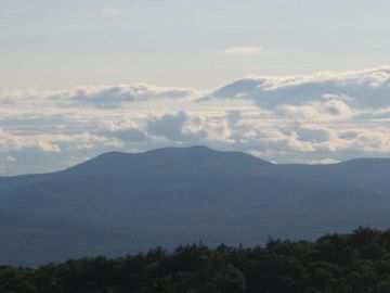
Mount Shaw facts for kids
Quick facts for kids Mount Shaw |
|
|---|---|
 |
|
| Highest point | |
| Elevation | 2,990 ft (910 m) |
| Prominence | 2,330 ft (710 m) |
| Listing | #23 New England Fifty Finest |
| Geography | |
| Location | Carroll County, New Hampshire, U.S. |
| Parent range | Ossipee Mountains |
| Topo map | USGS Melvin Village |
Mount Shaw is a cool mountain located in New Hampshire, United States. It stands in the towns of Moultonborough and Tuftonboro. Mount Shaw is special because it's the highest peak in the Ossipee Mountains.
What makes this mountain truly unique is that it's part of an ancient volcano. Imagine climbing a mountain that was once a giant, fiery peak millions of years ago!
Discovering Mount Shaw
Mount Shaw reaches a height of about 2,990 feet (911 meters) above sea level. It's found in Carroll County, New Hampshire. Even though it's not the tallest mountain in the state, it's quite impressive.
The mountain rises very high above the land around it. This is called "topographic prominence." Mount Shaw has a lot of prominence, making it stand out from other nearby peaks. It's one of only twelve peaks in New Hampshire with such a high prominence.
The Ancient Volcano
Mount Shaw is part of something called the Ossipee ring-dike complex. This complex is what's left of a huge stratovolcano. A stratovolcano is a tall, cone-shaped volcano, like Mount Fuji in Japan.
This ancient volcano was active about 125 million years ago! That was during the Cretaceous period, when dinosaurs roamed the Earth. The Ossipee complex is a part of the White Mountain igneous province, an area known for its old volcanic activity.
If you look at satellite maps, you can clearly see the circular shape of this old volcano. It's about 14 kilometers (9 miles) wide. Its edge is located about 8 kilometers (5 miles) northwest of the town of Ossipee.
Where the Water Flows
Mount Shaw is located within the beautiful Castle in the Clouds estate. Water from the mountain flows in different directions.
The north and southeast sides of Mount Shaw drain into the Lovell and Dan Hole rivers. From there, the water joins the Ossipee River, then the Saco River, and finally reaches the Gulf of Maine.
The southwest side of the mountain drains into the Melvin River. This river flows into Lake Winnipesaukee, a large and famous lake. From Lake Winnipesaukee, the water goes into the Winnipesaukee River, then the Merrimack River, and eventually into the Gulf of Maine in Massachusetts. So, water from Mount Shaw travels a long way to the ocean!
 | Valerie Thomas |
 | Frederick McKinley Jones |
 | George Edward Alcorn Jr. |
 | Thomas Mensah |

