Moultonborough, New Hampshire facts for kids
Quick facts for kids
Moultonborough, New Hampshire
|
||
|---|---|---|
|
Town
|
||
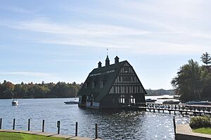
Swallow Boathouse in Moultonborough
|
||
|
||
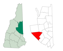
Location in Carroll County, New Hampshire
|
||
| Country | United States | |
| State | New Hampshire | |
| County | Carroll | |
| Incorporated | 1777 | |
| Villages |
|
|
| Area | ||
| • Total | 75.1 sq mi (194.5 km2) | |
| • Land | 59.7 sq mi (154.6 km2) | |
| • Water | 15.4 sq mi (39.9 km2) 20.50% | |
| Elevation | 610 ft (186 m) | |
| Population
(2020)
|
||
| • Total | 4,918 | |
| • Density | 82/sq mi (31.8/km2) | |
| Time zone | UTC-5 (Eastern) | |
| • Summer (DST) | UTC-4 (Eastern) | |
| ZIP code |
03254
|
|
| Area code(s) | 603 | |
| FIPS code | 33-49380 | |
| GNIS feature ID | 0873671 | |
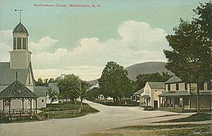
Moultonborough is a town in Carroll County, New Hampshire, United States. It's a beautiful place with a population of 4,918 people, according to the 2020 census. This number is higher than the 4,044 people counted in 2010.
Moultonborough is mostly surrounded by water. Lake Winnipesaukee borders it to the southwest. Squam Lake is in the northwestern part of the town. The town also includes the areas of Suissevale and Lees Mill.
Contents
History of Moultonborough
The first European settlers came from Hampton, New Hampshire. Many of them had the last name Moulton, which is how the town got its name. The very first town meeting happened on March 31, 1777. At this meeting, Jonathan Moulton was chosen as the town clerk.
The town was officially made a town, or "incorporated," on November 27, 1777. Colonel Moulton, who later became a brigadier general, was one of the richest people in the area during the American Revolution. The town was first given its charter in 1763 by Governor Benning Wentworth. At that time, it was described as being near "Winnepisseoky Pond."
Castle in the Clouds Estate
Moultonborough is home to a famous estate called "Castle in the Clouds." This amazing house is located in the Ossipee Mountains. A man named Thomas Gustave Plant became very rich by making shoes. He bought a huge piece of land, about 6,300 acres (25.5 square kilometers).
He hired architects from Boston to design his stone mansion, which was built between 1913 and 1914. The estate was named "Lucknow." Today, "Castle in the Clouds" offers amazing views of Lake Winnipesaukee and is a popular place for tourists to visit.
Historical Bear Incident
In August 1784, a sad event happened in Moultonborough. An eight-year-old boy, the son of a Mr. Leach, was attacked by a bear. He was looking after horses and cows in a field. His father heard his cries and tried to help, but couldn't save him.
The bear took the boy into the bushes. The family spent a difficult night. The next morning, neighbors helped search and found the boy's hat and tracks. They sadly found the boy's body. As they were mourning, the bear appeared again. Three people shot and killed the bear. A fire was then used to get rid of the bear's remains. This was the first known bear attack in Northern America.
Geography of Moultonborough
Moultonborough covers a total area of about 75.1 square miles (194.5 square kilometers). About 59.7 square miles (154.6 square kilometers) of this is land. The rest, about 15.4 square miles (39.9 square kilometers), is water. This means water makes up about 20.50% of the town's total area.
A big part of the town is along Lake Winnipesaukee. This is the largest lake in New Hampshire. Moultonborough Bay is an 8-mile (13 km) long arm of the lake. It stretches from the southern part of the town towards the center. Moultonborough Neck is a peninsula between Moultonborough Bay and Center Harbor. Long Island, the biggest island in Lake Winnipesaukee, is connected to Moultonborough Neck by a bridge.
The community of Suissevale is on the northeastern shore of Moultonborough Bay. Away from Winnipesaukee, Lake Kanasatka is in the western part of town. Red Hill, which is 2,029 feet (618 meters) high, is in the northwest. Mount Shaw, the highest point in Moultonborough, is 2,990 feet (911 meters) high. It is part of the Ossipee Mountains in the east.
The center of Moultonborough town is about 1 mile (1.6 km) north of Moultonborough Bay. It's where New Hampshire Route 25 and Route 109 meet. Route 25 is a main highway that goes east and west. It connects to places like Meredith and Plymouth to the west. To the east, it goes towards Ossipee, New Hampshire, and Portland, Maine. Route 109 is a local road. It goes southeast towards Wolfeboro and northwest to Center Sandwich.
Neighboring Towns
Moultonborough shares borders with these towns:
- Sandwich (north)
- Tamworth (northeast)
- Ossipee (northeast)
- Tuftonboro (east)
- Gilford (southeast)
- Meredith (south)
- Center Harbor (west)
- Holderness (west)
Moultonborough Population Facts
| Historical population | |||
|---|---|---|---|
| Census | Pop. | %± | |
| 1790 | 565 | — | |
| 1800 | 857 | 51.7% | |
| 1810 | 994 | 16.0% | |
| 1820 | 1,279 | 28.7% | |
| 1830 | 1,422 | 11.2% | |
| 1840 | 1,752 | 23.2% | |
| 1850 | 1,748 | −0.2% | |
| 1860 | 1,448 | −17.2% | |
| 1870 | 1,299 | −10.3% | |
| 1880 | 1,254 | −3.5% | |
| 1890 | 1,034 | −17.5% | |
| 1900 | 901 | −12.9% | |
| 1910 | 783 | −13.1% | |
| 1920 | 758 | −3.2% | |
| 1930 | 709 | −6.5% | |
| 1940 | 788 | 11.1% | |
| 1950 | 880 | 11.7% | |
| 1960 | 840 | −4.5% | |
| 1970 | 1,310 | 56.0% | |
| 1980 | 2,206 | 68.4% | |
| 1990 | 2,956 | 34.0% | |
| 2000 | 4,484 | 51.7% | |
| 2010 | 4,044 | −9.8% | |
| 2020 | 4,918 | 21.6% | |
| U.S. Decennial Census | |||
In 2000, there were 4,484 people living in Moultonborough. These people lived in 1,884 households, and 1,377 of these were families. The town had about 74.9 people per square mile (28.9 per square kilometer). There were also 4,523 housing units, like houses and apartments.
Most of the people in Moultonborough were White (98.48%). A small percentage were African American (0.13%), Native American (0.22%), or Asian (0.56%). About 0.62% of the population was Hispanic or Latino.
About 25.7% of households had children under 18 living there. Most households (63.7%) were married couples. About 26.9% of households were not families. The average household had 2.36 people, and the average family had 2.77 people.
The median age in Moultonborough was 47 years old. This means half the people were younger than 47 and half were older. About 21.1% of the population was under 18. About 19.9% were 65 years or older.
Education in Moultonborough
The Moultonborough School District serves the town. It includes two main schools: Moultonborough Academy and Moultonborough Central School.
Moultonborough Academy is for older students. It teaches grades six through twelve, covering both middle school and high school. You can find this school off Blake Road, just south of the main village area.
Moultonborough Central School is for younger students. It serves grades from kindergarten to fifth grade. This school is located on NH Route 25, close to the academy.
Places to Visit
Moultonborough has some interesting places to visit:
- Castle in the Clouds
- Geneva Point Center
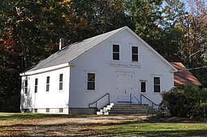
- Moultonborough Town House
Notable People from Moultonborough
Many interesting people have connections to Moultonborough:
- Benning M. Bean (1782–1866), a US congressman
- Jonathan Moulton (1726–1787), a colonel during the Revolutionary War
- Thomas Gustave Plant (1859–1941), a successful businessman
- Claude Rains (1889–1967), a famous actor, is buried here
- John M. True (1838–1921), a politician from Wisconsin
- John Greenleaf Whittier (1807–1892), a well-known poet who spent summers here
See also
 In Spanish: Moultonborough para niños
 | Selma Burke |
 | Pauline Powell Burns |
 | Frederick J. Brown |
 | Robert Blackburn |


