
Lake Winnipesaukee facts for kids
Quick facts for kids Lake Winnipesaukee |
|
|---|---|

Lake Winnipesaukee from summit of Mt. Major
|
|

Location in New Hampshire

Location in the United States
|
|
| Location | Belknap County and Carroll County, New Hampshire |
| Coordinates | 43°36′N 71°20′W / 43.600°N 71.333°W |
| Primary inflows | Gunstock River; Merrymeeting River; Melvin River; Red Hill River |
| Primary outflows | Winnipesaukee River |
| Basin countries | United States |
| Max. length | 20.8 mi (33.5 km) |
| Max. width | 9.0 mi (14.5 km) |
| Surface area | 71 sq mi (180 km2) |
| Max. depth | 180 ft (55 m) |
| Shore length1 | 288 mi (463 km) |
| Surface elevation | 504 ft (154 m) |
| Islands | 258 |
| Settlements | see article |
| 1 Shore length is not a well-defined measure. | |
Lake Winnipesaukee is the biggest lake in the U.S. state of New Hampshire. You can find it in the Lakes Region, near the White Mountains.
The lake is about 21 miles (34 km) long and 1 to 9 miles (1.6 to 14.5 km) wide. It covers about 71 square miles (184 km2) of water. The deepest part of the lake is 180 feet (55 m) deep. The wide, central part of the lake is called The Broads.
Lake Winnipesaukee has at least 264 islands. Many of these islands are quite small. The lake also has many peninsulas, which are pieces of land sticking out into the water. This creates a long shoreline of about 288 miles (463 km). Driving around the lake takes about 63 miles (101 km). The lake sits 504 feet (154 m) above sea level. It is the third-largest lake in New England.
Water flows out of the lake through the Lakeport Dam. This dam is in Lakeport, New Hampshire, and the water goes into the Winnipesaukee River.
| Top - 0-9 A B C D E F G H I J K L M N O P Q R S T U V W X Y Z |
History of Lake Winnipesaukee


The name Winnipesaukee comes from the Abenaki people. It means "smile of the Great Spirit" or "beautiful water in a high place." The Winnipesaukee people, a part of the Pennacook tribe, used to live and fish at a village called Acquadocton. This village was at the lake's outlet. Today, this spot is known as The Weirs. It was named after the weirs (fish traps) that early colonists saw there.
Lake Winnipesaukee has been a popular place for tourists for over 100 years. Many visitors come from Boston and New York City.
This lake was formed by glaciers. What's interesting is that the last ice age actually changed how the water flowed. The lake once flowed southeast towards the Atlantic Ocean through what is now Alton Bay. But glacial debris blocked this path. So, the water was redirected west through Paugus Bay into the Winnipesaukee River. This river then joins the Pemigewasset River to form the Merrimack River. The Merrimack River flows south to Massachusetts and into the Atlantic.
Center Harbor was the site of the first college sports event in the United States. On August 3, 1852, Harvard beat Yale in the first Harvard–Yale Regatta. One hundred years later, the schools raced again on Lake Winnipesaukee to celebrate. Harvard won that race too.
Towns Around the Lake
.jpg)
Many towns are located around Lake Winnipesaukee. Here they are, starting from the south and going clockwise:
- Alton: This is the biggest town by area in the Lakes Region.
- Gilford: This town is home to Gunstock Mountain Resort. It also has the Bank of New Hampshire Pavilion, a popular place for concerts.
- Laconia: This is the main business city on the lake. Weirs Beach, the biggest public beach on Winnipesaukee, is part of Laconia. Every year, Laconia hosts Bike Week. This event brings many thousands of motorcyclists to the area.
- Meredith: This town is a favorite spot for tourists on the northwest side of the lake.
- Center Harbor: This small town is where the MS Mount Washington boat stays during the winter.
- Moultonborough: This town has Castle in the Clouds, a large estate on top of a small mountain.
- Tuftonboro: This town includes the smaller communities of Melvin Village and Mirror Lake.
- Wolfeboro: This town calls itself the "Oldest Summer Resort in America."
Parts of the Lake
The lake has a wide, open central area called the Broads. Around it are several large bays and many smaller inlets.
Boats on the lake have a daytime speed limit of 45 miles per hour (72 km/h).
Here are the main sections of the lake:
The Broads
The Broads are a wide, open part of Lake Winnipesaukee. They are mostly in Belknap County and a bit in Carroll County. This area is large and has no islands in its center.
The Broads stretch along the main length of the lake. Their northwest end is near Center Harbor. The southeast end is between Alton and Wolfeboro.
Meredith Bay
Meredith Bay is on the western side of Winnipesaukee. At its northern end is the main village of Meredith. Paugus Bay branches off to the south of Meredith Bay, near Weirs Beach. Meredith Bay connects to the main part of the lake through a narrow strait. This strait is bordered by Governors Island to the south. The northeast shore of Meredith Bay is a long piece of land called Meredith Neck.
Paugus Bay
Paugus Bay used to be a separate lake. It joined Winnipesaukee when a dam was built at Lakeport. This dam raised the water level of Paugus Bay to meet Winnipesaukee. Paugus Bay connects to the main lake in Meredith Bay. It runs south from a narrow channel. At the northern end of Paugus Bay, where it meets the main lake, is Weirs Beach. This is the biggest and most visited public beach on the lake. At the other end is the village of Lakeport. Both Weirs Beach and Lakeport are villages within the city of Laconia. The eastern shore of the bay has many motels and hotels. The western shore is not as developed.
Alton Bay
Alton Bay is a narrow bay that goes south from the main lake's southern corner. It is completely within the town of Alton. The village of Alton Bay is at its very southern tip.
Wolfeboro Bay
Wolfeboro Bay is a smaller, wide bay in the town of Wolfeboro. It makes a small curve in the shoreline on the eastern side of Winnipesaukee. Several smaller lakes and streams connect Wolfeboro Bay to Lake Wentworth.
Winter Harbor
Winter Harbor is a Y-shaped bay with two branches. It is separated from the Broads by Wolfeboro Neck and Tuftonboro Neck. Many quiet resort communities are around Winter Harbor in the towns of Wolfeboro and Tuftonboro. It also offers great views of the Belknap Mountains and Rattlesnake Island.
Moultonborough Bay
Moultonborough Bay is the longest bay on Winnipesaukee. It connects to the Broads through narrow passages between a group of islands. These islands include Long Island (the largest island in the lake), Cow Island, Little Bear Island, and Sandy Island. The 7-mile-long (11 km) Moultonborough Neck separates the bay from the main part of the lake. The Suissevale area in Moultonborough is at the northern tip of the bay. Melvin Village, a lakeside village in Tuftonboro, is along the northeast shore of the bay.
Islands of Lake Winnipesaukee

Lake Winnipesaukee has at least 258 natural islands. These islands are at least 3 feet (0.9 m) above the lake's water level and have plants growing on them. About 130 of these islands are larger than .25 acres (0.10 ha). 26 islands are 25 acres (10 ha) or bigger:
- Long Island—1,186 acres (480 ha)
- Bear Island—780 acres (320 ha)
- Cow Island—522 acres (211 ha)
- Governors Island—504 acres (204 ha)
- Rattlesnake Island—368 acres (149 ha)
- Welch Island—187 acres (76 ha)
- Little Bear Island—143 acres (58 ha)
- Stonedam Island—141 acres (57 ha)
- Timber Island—136 acres (55 ha)
- Sleepers Island—113 acres (46 ha)
- Mark Island—102 acres (41 ha)
- Black Island—90 acres (36 ha)
- Barndoor Island—88 acres (36 ha)
- Black Cat Island—75 acres (30 ha)
- Pine Island—74 acres (30 ha)
- Whortleberry Island—69 acres (28 ha)
- Sandy Island—67 acres (27 ha)
- Jolly Island—50 acres (20 ha)
- Three Mile Island—47 acres (19 ha)
- Round Island—43 acres (17 ha)
- Lockes Island—42 acres (17 ha)
- Diamond Island—37 acres (15 ha)
- Dow Island—32 acres (13 ha)
- Big Beaver Island—30 acres (12 ha)
- Camp Island—28 acres (11 ha)
- Mink Island—26 acres (11 ha)
- Birch Island—25 acres (10 ha)
Six islands are connected to the mainland by bridges. These are Black Cat, Governors, Long, Oak, Christmas (or Plummers) in Paugus Bay, and Worcester. Another eight islands get mail delivered by the U.S. mail boat M/V Sophie C. These islands are Bear, Birch, Cow, East Bear, Jolly, Loon, Three Mile, and Sandy.
The Lakes Region
Lake Winnipesaukee is part of New Hampshire's Lakes Region. This area also includes lakes like Lake Winnisquam, Lake Wentworth, Squam Lake, and Newfound Lake. For over a century, this region has been a popular vacation spot, especially for people from Boston.
The area offers many fun activities on land and water. There are also many hiking trails in the surrounding mountains. These mountains include the Ossipee Mountains to the east, the Belknap Range to the west, and Red Hill to the north.
Ships on the Lake
The Mount Washington Steamship

The paddlesteamer MS Mount Washington was launched in the spring of 1872. It was named after the tallest of New Hampshire's White Mountains. This ship carried mail, goods, and passengers on Lake Winnipesaukee. It was 178 feet (54 m) long and 49 feet (15 m) wide. It was the largest steamer on the lake at that time. Its huge paddle wheels were powered by a steam engine. The ship was known as "The Mount," and its kitchen and restaurant were very famous.
On December 23, 1939, a fire started at a nearby train station. The fire spread to the ship, which was tied at the dock, and destroyed it. The ship was stuck in the mud because the water level was very low. Soon after, a local company decided to build a new ship. Since World War II was starting, it was hard to get steel. So, they bought an old sidewheel boat called the Chateaugay from Lake Champlain. This boat was 203-foot (62 m) long and had an iron hull. It was cut into sections and brought to Lake Winnipesaukee by train. A new ship was designed using this hull, and it was welded back together. The new MS Mount Washington had its first trip on August 15, 1940.
Two years later, the new Mount Washington had its engines and boilers removed. They were used for a navy ship during World War II. After the war, the Mount Washington returned to the water. It was very popular during the tourist boom after the war.
In 1982, the Mount Washington was made longer by 20-foot (6.1 m). This added more space for lounges and food service. It is still popular today. It makes one or two trips around the lake each day in the summer. It also offers dinner dance cruises in the evenings.
The Mailboat M/V Sophie C.
.jpg)
The M/V Sophie C. is a special boat. It is the oldest floating United States Postal Service post office still working today. Floating post office service began on Lake Winnipesaukee in 1892. The Sophie C. delivers mail every day to eight of the lake's islands from June to September. The Sophie C. was built in 1945. It took over the mail route from another boat, the Uncle Sam II, in 1969.
As a floating post office, the Sophie C. delivers mail from Monday to Saturday. It also sells stamps and collects outgoing mail. The Sophie C. is also a sightseeing boat. It can carry up to 125 people on its two daily cruises. While delivering mail, it also sells ice cream and snacks to the island residents. In 2018 and 2019, another boat, the M/V Doris E., took over the mail route while the Sophie C. was being repaired.
Seaplane Base
The Alton Bay Seaplane Base is a public seaplane base in Alton Bay. This is the southeast part of the lake. In the winter, if conditions are right, it becomes the only FAA-approved ice runway in the contiguous United States.
Weather and Climate
In the summer, the average daytime temperature near the water is around 80 °F (26 °C). Nights are usually around 65 °F (18 °C). A little further from the water, days can be warmer and nights cooler. Summer extreme temperatures can reach 100 °F (38 °C) and drop to 50 °F (10 °C).
A typical winter day has a high of 28 °F (−2 °C) and a low of 15 °F (−9 °C). Winter extremes can be 50 °F (10 °C) and −20 °F (−30 °C). Even colder temperatures have been recorded nearby.
The water temperature usually reaches the upper 70s F (around 25 °C) in late July. It cools to the 60s (around 18 °C) in September. After several hot, humid days in summer, the water can get above 80 °F (26 °C). The lake usually freezes during the last week of December. In a typical winter, the ice can be thicker than 18 inches (460 mm) in many parts of the lake.
Ice-In and Ice-Out
Lake Winnipesaukee is famous for its yearly Ice-Out Contest. People try to guess the earliest date when the Mount Washington boat can safely leave its port in Center Harbor. It then has to motor to four other ports: Weirs Beach, Alton Bay, Wolfeboro, and Meredith.
Records have been kept since 1851. The ice-out has happened as early as March 18 and as late as May 12. However, 90 percent of the time, it is declared in April. David Emerson of Emerson Aviation makes the official ruling.
Images for kids
-
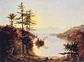
View on Lake Winnipiseogee (1828) by American painter Thomas Cole
-
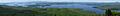
Panoramic view of Lake Winnipesaukee looking north from the summit of Mount Major. The entrance to Alton Bay is at the right edge. The large island near the center-left is Rattlesnake Island. The three islands in front of it (left to right) are Sleeper's Island, Cub Island, and Treasure Island. Diamond Island is to the left of Rattlesnake Island. Wolfeboro Bay is visible on the far side of the lake near the center-right.

See also
 In Spanish: Lago Winnipesaukee para niños
