Lake Wentworth facts for kids
Quick facts for kids Lake Wentworth |
|
|---|---|

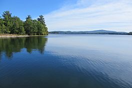
Lake Wentworth from west end near Fernalds Basin, Wolfeboro, NH
|
|
| Location | Carroll County, New Hampshire |
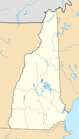
| Coordinates | 43°35′50″N 71°9′36″W / 43.59722°N 71.16000°W |
| Type | Glacial |
| Primary inflows | 9 named brooks |
| Primary outflows | Smith River to Crescent Lake |
| Basin countries | United States |
| Max. length | 3.9 mi (6.3 km) |
| Max. width | 2.2 mi (3.5 km) |
| Surface area | 3,097 acres (12.53 km2) |
| Average depth | 25 feet (7.6 m) |
| Max. depth | 80 feet (24 m) at Fullers Deep |
| Shore length1 | 20 miles (32 km) |
| Surface elevation | 534 ft (163 m) |
| Islands | 18 |
| Settlements | Wolfeboro |
| 1 Shore length is not a well-defined measure. | |
Lake Wentworth is a beautiful lake found in Carroll County, in the eastern part of New Hampshire, United States. It is located in the town of Wolfeboro. Covering about 3,097 acres (12.53 km2), it is the seventh-largest lake that is completely within New Hampshire. Water from Lake Wentworth flows into Crescent Lake through a short river called the Smith River. From there, it goes over a dam and into Lake Winnipesaukee in Wolfeboro. You can visit Wentworth State Park, which is 50-acre (20 ha) big, to enjoy public access to the lake.
Contents
Exploring Lake Wentworth's Environment
How Water Flows in the Lake Area
The area around Lake Wentworth and Crescent Lake is part of a larger water system. This system is a smaller part of the Lake Winnipesaukee watershed, which then connects to the even bigger Merrimack River watershed. A watershed is an area of land where all the water drains into a common point, like a lake or river.
This specific area, called the Wentworth-Crescent sub-watershed, covers about 37-square-mile (96 km2). It includes three main water bodies: Sargents Pond, Crescent Lake, and Lake Wentworth. It also has 11 smaller streams that flow all year round. In total, this area has over 4,000 acres (16 km2) of surface water, 617 acres (2.50 km2) of wetlands (like swamps or marshes), and more than 15 miles (24 km) of shoreline. The Wentworth Watershed Association is a group that works hard to protect the land and water in this important area.
Checking Lake Wentworth's Water Quality
Lake Wentworth is part of a special program where volunteers help check the water quality. This program is called the UNH Extension Lakes Lay Monitoring Program. People have been collecting information about the lake's water quality since 1984.
Lake Wentworth generally has excellent water quality. It is considered oligotrophic, which means it has very clear water and low levels of nutrients. However, in its deepest parts, the water quality is fair. This is because there are low levels of dissolved oxygen there. Dissolved oxygen is important for fish and other water creatures to breathe.
Fish You Might Find in Lake Wentworth
Lake Wentworth is known as a warmwater fishery. This means it's a good place for fish that prefer warmer water. Some of the fish you might see or catch in the lake include:
Islands of Lake Wentworth
Lake Wentworth is home to at least 18 named islands, plus many smaller rocks and ledges. The largest island is Stamp Act Island, which is 106 acres (43 ha) big. Other islands include Bass Island, Cate Island, Mink Island, Goose Island, East and West Jockey Cap Islands, Triggs Island, Turtle Island, Fanny Island, and Brummet Island. There's also a group of islands called the Seven Sisters Islands.
Meet the Seven Sisters Islands
The Seven Sisters Islands are a group of seven islands: Sister, Poplar, Loon, Flo, Min, Joe, and Wal.
- Poplar Island: This island was once owned by C.B. Edgerly and J.M. Cate. Later, in 1910, it was sold to Rev. F.H. Spear, who built the first building there, a boathouse.
- Sister Island: This island was originally owned by Daniel "Old Dan" Kimball, who had a small cabin there. It was also called Wakefield Island after a later owner, John F. Wakefield.
- Loon Island: This island used to have a hotel called Estes Hotel, run by John Estes. It was known for its lively parties.
- Wal and Flo Islands: Today, loons, a type of water bird, often build their nests on Wal and Flo islands.
Other Notable Islands
- Bass Island: This island is the seventh largest in the lake. It's named after the bass fish, which are common in the lake. It used to be called Goss Island, after its first owner, Walter Goss. There is one house on the island today. Bass Island is connected to Stamp Act Island by an underwater reef.
- Brummitt Island: This is one of the smallest islands that people have lived on. However, there are no houses on it now. It was first lived on by Henry D. Brewster and was called Townsend's Islands.
- Cate Island: Named after the Cate family, who also owned part of Stamp Act Island. This island has had other names like Thaddeus Island and Murray's Island. A camp on the island burned down in 1929, possibly due to a lightning strike.
- Goose and Fanny Island: These two islands are not lived on and are close to the shore. Fanny Island is near Kimball Shore, and Goose Island is near Hodge Shore.
- Mink Island and the Jockey Caps: Mink Island is named after the American Mink, an animal often seen there. It was called Wentworth Island almost 100 years ago. The Jockey Cap islands are named after the hats worn in horse racing. Cabins were built on both East and West Jockey Cap islands over a century ago.
- Stamp Act Island: This is the largest island in Lake Wentworth. It is now a nature preserve, protected by The Nature Conservancy. In the 1970s, there was a concern that the island might be sold to a private company that wanted to build many homes there. The island's name is a mystery, but it refers to the Stamp Act from the 1700s, which helped start the American Revolution. Some stories say that documents from the Stamp Act were hidden there.
- Triggs Island: This is the second largest island in the lake, located near Triggs Shore. It's named after the Triggs family, who owned it for a long time. It used to be called Minister's Island because many religious leaders lived there. In 1904, it was sold to three Methodist ministers. They built five cottages. Triggs Island is one of only two islands with electricity, which comes from wires in an underwater tube.
- Turtle Island: This is the sixth largest island in the lake, less than 100 yards from the shore. Lady Wentworth, a historical figure, used to have picnics here with her family and friends. They would reach the island using a natural path that some believe the Wentworth family might have improved. Turtle Island is the other island that has electricity, with a wire running over the water to it.
 | DeHart Hubbard |
 | Wilma Rudolph |
 | Jesse Owens |
 | Jackie Joyner-Kersee |
 | Major Taylor |


