
Alton, New Hampshire facts for kids
Quick facts for kids
Alton, New Hampshire
|
||
|---|---|---|

Monument Square in the center of Alton
|
||
|
||

Location in Belknap County, New Hampshire
|
||
| Country | United States | |
| State | New Hampshire | |
| County | Belknap | |
| Incorporated | 1796 | |
| Villages | ||
| Area | ||
| • Total | 83.2 sq mi (215.4 km2) | |
| • Land | 63.7 sq mi (165.0 km2) | |
| • Water | 19.5 sq mi (50.5 km2) 23.42% | |
| Elevation | 560 ft (171 m) | |
| Population
(2020)
|
||
| • Total | 5,894 | |
| • Density | 92/sq mi (35.7/km2) | |
| Time zone | UTC−5 (Eastern) | |
| • Summer (DST) | UTC−4 (Eastern) | |
| ZIP codes |
03809 (Alton)
03810 (Alton Bay) |
|
| Area code(s) | 603 | |
| FIPS code | 33-01060 | |
| GNIS feature ID | 0873530 | |

Alton is a fun town in Belknap County, New Hampshire, United States. In 2020, about 5,894 people lived there. It's a great place to visit because it has two cool forests: Alton Bay State Forest and Mount Major State Forest.
The main part of town is called Alton. About 499 people lived there in 2020. It's located where two main roads, New Hampshire Route 11 and New Hampshire Route 140, meet. The town also includes the village of Alton Bay. This village is a popular vacation spot right next to Lake Winnipesaukee.
Contents
Alton's Early Days and Growth
Alton was first settled around 1770. It was originally known as "New Durham Gore." This name came from its rocky, upland areas. Farmers liked these higher lands because they had less frost. Later, merchants moved into the lower areas.
Becoming a Town
The farmers and merchants worked together to officially create the town. On January 15, 1796, Alton became an official town. It was named after Alton, a small market town in England.
Alton was part of Strafford County for a while. Then, on December 22, 1840, it became part of the new Belknap County. By 1840, the village of Alton was growing in the town's center.
Railroads and Inventions
In 1847, the Cochecho Railroad started bringing people and goods to Alton. This helped the town grow even more. By 1859, Alton had many businesses. There were two gristmills (for grinding grain), seven sawmills (for cutting wood), and five shoe factories.
One of the most famous businesses was the Rockwell Clough Company. It was started by William Rockwell Clough. He invented the corkscrew! By 1903, his company was making 30 million corkscrews every year.
Tourism Becomes Important
Since the mid-1800s, tourism has been Alton's main business. In 1863, a religious group held a large meeting at Alton Bay. This spot was the end of the Dover and Winnipiseogee Railroad line. In 1876, this group became the Alton Bay Camp Meeting Association. Today, it's known as the Alton Bay Christian Conference Center.
In 1872, the Boston & Maine Railroad launched a large steamer called the Mount Washington at Alton Bay. It was the first side-wheeler and the biggest ship on Lake Winnipesaukee. Even after it was destroyed by fire in 1939, a new ship was found and also named Mount Washington. This ship still takes tourists around the lake today. The railway stopped running in 1935. The old station at Alton Bay is now a community center.
Alton's Geography and Nature
Alton is a large town, covering about 215.4 square kilometers (83.2 square miles). A big part of it, about 23.4%, is water. Alton is located at the southern end of Lake Winnipesaukee. It has a long inlet called Alton Bay, which is about 4 miles long.
Villages and Waterways
The village of Alton Bay is at the very end of this bay. The main village of Alton is about 1 mile further south. The Merrymeeting River flows into Alton Bay.
Mountains and Views
Mount Major is a popular spot for hikers. It's part of the Mount Major State Forest. The top of Mount Major is about 542 meters (1,780 feet) above sea level. From there, you can see amazing views of Lake Winnipesaukee. The highest point in Alton is the north peak of Straightback Mountain. It's about 582 meters (1,910 feet) high. Both Mount Major and Straightback Mountain are part of the Belknap Mountains range.
Most of Alton is in the Merrimack River watershed. This means its water flows towards the Merrimack River. A small part of the town is in the Piscataqua River watershed, which flows to the coast.
Roads and Connections
Five state highways serve Alton. New Hampshire Route 11 goes through the center of town. It connects Alton to towns like Gilford, Laconia, and Rochester. New Hampshire Route 28 also passes through the town center. It leads north to Wolfeboro and south to Pittsfield and Manchester.
New Hampshire Route 140 connects Alton west to Gilmanton and Tilton. There are also New Hampshire Route 11A and New Hampshire Route 28A. These roads help people travel easily around Alton and to nearby towns.
Neighboring Towns
Alton shares its borders with several other towns:
- Wolfeboro (north)
- New Durham (east)
- Barnstead (south)
- Gilmanton (southeast)
- Gilford (west)
- Tuftonboro (northwest)
Alton's Population Over Time
| Historical population | |||
|---|---|---|---|
| Census | Pop. | %± | |
| 1790 | 445 | — | |
| 1800 | 721 | 62.0% | |
| 1810 | 1,279 | 77.4% | |
| 1820 | 2,058 | 60.9% | |
| 1830 | 1,993 | −3.2% | |
| 1840 | 2,002 | 0.5% | |
| 1850 | 1,795 | −10.3% | |
| 1860 | 2,018 | 12.4% | |
| 1870 | 1,768 | −12.4% | |
| 1880 | 1,476 | −16.5% | |
| 1890 | 1,372 | −7.0% | |
| 1900 | 1,500 | 9.3% | |
| 1910 | 1,348 | −10.1% | |
| 1920 | 1,221 | −9.4% | |
| 1930 | 1,261 | 3.3% | |
| 1940 | 1,209 | −4.1% | |
| 1950 | 1,189 | −1.7% | |
| 1960 | 1,241 | 4.4% | |
| 1970 | 1,647 | 32.7% | |
| 1980 | 2,440 | 48.1% | |
| 1990 | 3,286 | 34.7% | |
| 2000 | 4,502 | 37.0% | |
| 2010 | 5,250 | 16.6% | |
| 2020 | 5,894 | 12.3% | |
| U.S. Decennial Census | |||
In 2010, Alton had 5,250 people living there. There were 2,145 households. Most people in Alton were white (98.4%). A small number were from other racial backgrounds. About 1.1% of the population were Hispanic or Latino.
About 28.4% of households had children under 18. Many households (59.0%) were married couples living together. The average household had 2.45 people. The average family had 2.87 people.
About 21.1% of the people in Alton were under 18 years old. About 16.9% were 65 years or older. The average age in Alton was 46.2 years.
Fun Places to Visit in Alton
- Alton Historical Society & Museum: Learn about the town's past.
- Harold S. Gilman Museum: Another great place to explore history.
- Alton Bay: This area has lots of fun things to do!
- You can find an arcade, mini-golf, and ice cream shops.
- There are many places to eat and a marina for boats.
- New Hampshire Historical Marker No. 164: Alton Bay Transportation Center – learn about how people used to travel here.
- New Hampshire Historical Marker No. 288: The Alton Bay Water Bandstand – a unique stage over the water.
Historic Photos
-
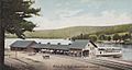
Steamer landing in 1905
-
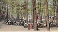
Advent Grove in 1910
-
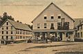
Boarding house in 1907
-
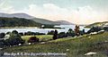
Alton Bay and Lake Winnipesaukee in 1905


Famous People From Alton
- Joel Bean (1825–1914): He started a religious group called Beanite Quakerism.
- George Franklin Drew (1827–1900): He was the 12th governor of Florida.
- James B. French (1857–1932): He was a member of the Wisconsin State Assembly.
- Steve Leach (born 1966): A professional ice hockey player who played for seven NHL teams.
- Don Sweeney (born 1966): Another professional ice hockey player for the Boston Bruins and Dallas Stars. He is now the general manager for the Boston Bruins.
See also
 In Spanish: Alton (Nuevo Hampshire) para niños
