New Durham, New Hampshire facts for kids
Quick facts for kids
New Durham, New Hampshire
|
||
|---|---|---|
|
Town
|
||

|
||
|
||

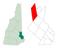
Location in Strafford County, New Hampshire
|
||
| Country | United States | |
| State | New Hampshire | |
| County | Strafford | |
| Incorporated | 1762 | |
| Villages |
|
|
| Area | ||
| • Total | 43.8 sq mi (113.5 km2) | |
| • Land | 41.2 sq mi (106.7 km2) | |
| • Water | 2.6 sq mi (6.8 km2) 5.98% | |
| Elevation | 544 ft (166 m) | |
| Population
(2020)
|
||
| • Total | 2,693 | |
| • Density | 65/sq mi (25.2/km2) | |
| Time zone | UTC-5 (Eastern) | |
| • Summer (DST) | UTC-4 (Eastern) | |
| ZIP code |
03855
|
|
| Area code(s) | 603 | |
| FIPS code | 33-51220 | |
| GNIS feature ID | 0873677 | |
New Durham is a small town in Strafford County, New Hampshire, in the United States. In 2020, about 2,693 people lived there.
The town has several rivers, including the Merrymeeting, Cocheco, and Ela rivers. It is also famous for Merrymeeting Lake. New Durham is home to the Powder Mill Fish Hatchery, where fish are raised. You can also find Camp Pride here, a special camp for children and adults with unique needs, run by the Lions Club.
Contents
History of New Durham
New Durham was first given its land by the Masonian Proprietors in 1749. These were people who owned large areas of land in New Hampshire. The town was called "Cochecho Township" at first.
European settlers arrived in 1750. Most of them came from a nearby town called Durham. This is why the new town was named "New Durham." It officially became a town on December 7, 1762.
The land in New Durham was a bit rocky and uneven. This made it better for raising animals like cows than for growing crops. Because of this, cutting down trees and selling wood became very important. By 1859, New Durham had five sawmills, which cut logs into wood. It also had four shingle mills, which made roof shingles.
The town also had two gristmills, which ground grain into flour. There was even a factory called Eureka Powder Works that made gunpowder. In 1849, a train line called the Cocheco Railroad opened. It connected New Durham to other towns like Dover and Alton Bay.
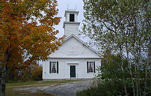
An early minister in the town was Reverend Benjamin Randall. In 1780, he started a new religious group called the Free Will Baptists. This group later became known as Free Baptists. There are two church buildings for this group in New Durham. The older one was built in 1819 on New Durham Ridge.
Geography and Nature
New Durham covers about 113.5 square kilometers (43.8 square miles) in total. Most of this area is land, about 106.7 square kilometers (41.2 square miles). The rest, about 6.8 square kilometers (2.6 square miles), is water.
The southern part of New Durham has the beginnings of the Cocheco River and a smaller river called the Ela River. These rivers flow towards the Piscataqua River and eventually reach the Atlantic Ocean at Portsmouth.
In the northern part of town, you'll find Merrymeeting Lake. Water from this lake flows into the Merrymeeting River. This river then goes west to Lake Winnipesaukee. The water from Lake Winnipesaukee eventually joins the Merrimack River.
The highest point in New Durham is about 1700 feet (518 meters) above sea level. This spot is on the side of Copple Crown Mountain. The very top of Copple Crown Mountain, which is 1868 feet (569 meters) high, is actually in the next town over, Brookfield.
New Hampshire Route 11 is a main road that helps people travel through New Durham.
Neighboring Towns
New Durham shares its borders with several other towns:
- Wolfeboro (to the north)
- Brookfield (to the northeast)
- Middleton (to the east)
- Farmington (to the southeast)
- Alton (to the west)
Population Over Time
| Historical population | |||
|---|---|---|---|
| Census | Pop. | %± | |
| 1790 | 554 | — | |
| 1800 | 742 | 33.9% | |
| 1810 | 888 | 19.7% | |
| 1820 | 1,168 | 31.5% | |
| 1830 | 1,162 | −0.5% | |
| 1840 | 1,032 | −11.2% | |
| 1850 | 1,049 | 1.6% | |
| 1860 | 1,173 | 11.8% | |
| 1870 | 973 | −17.1% | |
| 1880 | 772 | −20.7% | |
| 1890 | 579 | −25.0% | |
| 1900 | 625 | 7.9% | |
| 1910 | 523 | −16.3% | |
| 1920 | 462 | −11.7% | |
| 1930 | 448 | −3.0% | |
| 1940 | 433 | −3.3% | |
| 1950 | 463 | 6.9% | |
| 1960 | 474 | 2.4% | |
| 1970 | 583 | 23.0% | |
| 1980 | 1,183 | 102.9% | |
| 1990 | 1,974 | 66.9% | |
| 2000 | 2,220 | 12.5% | |
| 2010 | 2,638 | 18.8% | |
| 2020 | 2,693 | 2.1% | |
| U.S. Decennial Census | |||
The population of New Durham has changed a lot over the years. In 1790, there were 554 people living here. The number grew steadily for a while, reaching over 1,100 people in the 1820s.
Then, the population slowly went down for many years. By 1940, only 433 people lived in New Durham. After that, the population started to grow again. By 2020, it had reached 2,693 people.
In 2000, there were 2,220 people living in New Durham. About 819 households were in the town. Many of these households, about 67%, were married couples living together. About 36% of households had children under 18 living with them.
The average household had about 2.7 people. The average family had about 3 people. The median age in the town was 38 years old. This means half the people were younger than 38, and half were older.
Famous People from New Durham
- Alfred M. Jones (1837–1910) – He was born in New Durham and later became a politician and businessman in the Midwest.
- Benjamin Randall (1749–1808) – He was a minister who started the Free Will Baptist religious group in New Durham.
See also
 In Spanish: New Durham (Nuevo Hampshire) para niños
 | Selma Burke |
 | Pauline Powell Burns |
 | Frederick J. Brown |
 | Robert Blackburn |


