Brookfield, New Hampshire facts for kids
Quick facts for kids
Brookfield, New Hampshire
|
||
|---|---|---|
|
Town
|
||

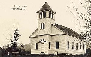
Brookfield Town Hall in 1915
|
||
|
||

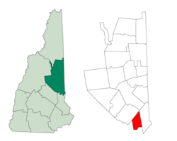
Location in Carroll County, New Hampshire
|
||
| Country | United States | |
| State | New Hampshire | |
| County | Carroll | |
| Incorporated | December 12, 1794 | |
| Area | ||
| • Total | 23.2 sq mi (60.2 km2) | |
| • Land | 22.8 sq mi (59.1 km2) | |
| • Water | 0.4 sq mi (1.1 km2) 1.82% | |
| Elevation | 604 ft (184 m) | |
| Population
(2020)
|
||
| • Total | 755 | |
| • Density | 33/sq mi (12.8/km2) | |
| Time zone | UTC-5 (Eastern) | |
| • Summer (DST) | UTC-4 (Eastern) | |
| ZIP code |
03872
|
|
| Area code(s) | 603 | |
| FIPS code | 33-07940 | |
| GNIS feature ID | 0873553 | |
Brookfield is a small town in Carroll County, New Hampshire, United States. It is known for its quiet, rural setting. In 2020, the town had a population of 755 people.
Contents
History of Brookfield
Brookfield was first settled in 1726 by people from Scotland and Ireland. They called the town "Coleraine" after a town in what is now Northern Ireland. The land was very good for farming, which made it a popular place for settlers.
Later, the town's name was changed to "Brookfield." It was named after Brookfield, Massachusetts. At first, Brookfield was part of another town called Middleton.
However, traveling between the two parts of Middleton was hard. A long, high ridge of the Moose Mountains separated them. This made it especially difficult to attend town meetings, which were often held in March when roads were muddy.
In 1785, Brookfield tried to become its own separate town, but it didn't work. Finally, in 1794, permission was granted, and Brookfield officially became an independent town. This process is called being "incorporated."
Years later, in 1840, Carroll County was created. Brookfield became part of Carroll County, while Middleton stayed in Strafford County. In 1874, a train line called the Wolfeborough Branch Railroad was built through Brookfield.
Geography of Brookfield
Brookfield covers a total area of about 60.2 square kilometers (about 23.2 square miles). Most of this area, 59.1 square kilometers (22.8 square miles), is land. The remaining 1.1 square kilometers (0.4 square miles) is water, which makes up about 1.82% of the town's total area.
The town's water mostly flows into the Branch River and Pike Brook. These rivers are part of the Piscataqua River watershed. A watershed is an area of land where all the water drains into a single river or body of water. A small part of Brookfield's western side drains into the Merrimack River watershed. The very northern tip of the town drains into the Saco River watershed.
The highest point in Brookfield is Copple Crown Mountain. It is located along the western border of the town. This mountain reaches an elevation of about 570 meters (1,868 feet) above sea level.
New Hampshire Route 109 is a main road that passes through Brookfield, connecting it to other areas.
Neighboring Towns
Brookfield shares its borders with several other towns:
- Wolfeboro to the north
- Wakefield to the east
- Middleton to the south
- New Durham to the southwest
Population Changes
| Historical population | |||
|---|---|---|---|
| Census | Pop. | %± | |
| 1800 | 504 | — | |
| 1810 | 657 | 30.4% | |
| 1820 | 690 | 5.0% | |
| 1830 | 679 | −1.6% | |
| 1840 | 553 | −18.6% | |
| 1850 | 552 | −0.2% | |
| 1860 | 510 | −7.6% | |
| 1870 | 416 | −18.4% | |
| 1880 | 428 | 2.9% | |
| 1890 | 349 | −18.5% | |
| 1900 | 296 | −15.2% | |
| 1910 | 247 | −16.6% | |
| 1920 | 186 | −24.7% | |
| 1930 | 166 | −10.8% | |
| 1940 | 142 | −14.5% | |
| 1950 | 159 | 12.0% | |
| 1960 | 145 | −8.8% | |
| 1970 | 198 | 36.6% | |
| 1980 | 385 | 94.4% | |
| 1990 | 518 | 34.5% | |
| 2000 | 604 | 16.6% | |
| 2010 | 712 | 17.9% | |
| 2020 | 755 | 6.0% | |
| U.S. Decennial Census | |||
The population of Brookfield has changed a lot over the years. In 1800, there were 504 people living in the town. The population grew for a while, reaching 690 people in 1820.
However, the number of residents then started to decrease for many years. By 1940, only 142 people lived in Brookfield. Since then, the population has been growing steadily. In 2020, the town's population reached 755 people.
See also
 In Spanish: Brookfield (Nuevo Hampshire) para niños
 | Jewel Prestage |
 | Ella Baker |
 | Fannie Lou Hamer |


