Middleton, New Hampshire facts for kids
Quick facts for kids
Middleton, New Hampshire
|
|
|---|---|
|
Town
|
|

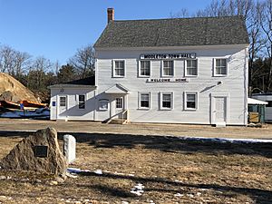
Historic Middleton Town Hall in 2020
|
|

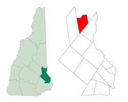
Location within Strafford County, New Hampshire
|
|
| Country | United States |
| State | New Hampshire |
| County | Strafford |
| Settled | 1749 |
| Incorporated | 1778 |
| Village | Middleton Corners |
| Area | |
| • Total | 18.5 sq mi (47.9 km2) |
| • Land | 18.1 sq mi (46.8 km2) |
| • Water | 0.4 sq mi (1.1 km2) |
| Elevation | 770 ft (230 m) |
| Population
(2020)
|
|
| • Total | 1,823 |
| • Density | 101/sq mi (38.9/km2) |
| Time zone | UTC-5 (EST) |
| • Summer (DST) | UTC-4 (EDT) |
| ZIP code |
03887
|
| Area code(s) | 603 |
| FIPS code | 33-47700 |
| GNIS feature ID | 0873664 |
Middleton is a small town in New Hampshire, located in Strafford County. It is part of the United States. In 2020, about 1,823 people lived there.
History of Middleton
Middleton was first given its land by the Masonian Proprietors in 1749. These were a group of people who owned a lot of land in New Hampshire. The town was named after Sir Charles Middleton, 1st Baron Barham. He was important for helping ships travel safely between Barbados and the American colonies.
The first settlers arrived in Middleton just before the Revolutionary War. They came from nearby towns like Lee and Rochester. After the war, some families, including a group of Quakers, moved away. They were looking for a more peaceful place to live.
The land in Middleton is quite rocky, which made it hard for farming crops. However, people in Middleton were good at making cider from apples. They also made some maple syrup.
Middleton was located on an important road. This road connected the Seacoast of New Hampshire to Wolfeboro. Wolfeboro was where the colonial governor, John Wentworth, had his summer home called "Kingswood." Today, parts of this old road are still called "Governors Road" and "Kings Highway."
Middleton officially became a town on March 4, 1778. At first, it included the area that is now Brookfield. But Brookfield became its own town in 1794.
The old Town Hall in Middleton is a very historic building. It was built in 1795 as a meetinghouse, which was a place for community gatherings and worship. It was moved to its current spot in 1812. The building was lifted up, and the Town Hall part was built underneath it. Inside, there's a special painting called a mural. It's a landscape of trees and scenery that wraps around the room. An artist named John Avery painted it in 1811.
Geography and Nature
Middleton covers a total area of about 47.9 square kilometers (about 18.5 square miles). Most of this area is land, about 46.8 square kilometers (18.1 square miles). The rest, about 1.1 square kilometers (0.4 square miles), is water.
The main body of water in town is Sunrise Lake. This lake drains south towards the Cocheco River. Other parts of Middleton drain east into the Branch River. This river is a branch of the Salmon Falls River. A stream called Jones Brook also flows through the middle of town.
The entire town of Middleton is part of the Piscataqua River watershed. This means all the water from Middleton eventually flows into the Piscataqua River.
The Moose Mountains are located near Middleton, separating it from Brookfield. These mountains have peaks that are between 1,600 and 1,700 feet high. The highest point in Middleton is one of these peaks, reaching about 1,670 feet (509 meters) above sea level.
The town is served by New Hampshire Route 153, which is a main road for travel.
Neighboring Towns
Middleton is surrounded by several other towns:
- Brookfield (to the north)
- Wakefield (to the northeast)
- Milton (to the southeast)
- Farmington (to the south)
- New Durham (to the west)
Population and People
| Historical population | |||
|---|---|---|---|
| Census | Pop. | %± | |
| 1790 | 617 | — | |
| 1800 | 431 | −30.1% | |
| 1810 | 439 | 1.9% | |
| 1820 | 482 | 9.8% | |
| 1830 | 562 | 16.6% | |
| 1840 | 483 | −14.1% | |
| 1850 | 476 | −1.4% | |
| 1860 | 530 | 11.3% | |
| 1870 | 476 | −10.2% | |
| 1880 | 355 | −25.4% | |
| 1890 | 207 | −41.7% | |
| 1900 | 300 | 44.9% | |
| 1910 | 291 | −3.0% | |
| 1920 | 174 | −40.2% | |
| 1930 | 176 | 1.1% | |
| 1940 | 236 | 34.1% | |
| 1950 | 255 | 8.1% | |
| 1960 | 349 | 36.9% | |
| 1970 | 430 | 23.2% | |
| 1980 | 734 | 70.7% | |
| 1990 | 1,183 | 61.2% | |
| 2000 | 1,440 | 21.7% | |
| 2010 | 1,783 | 23.8% | |
| 2020 | 1,823 | 2.2% | |
| U.S. Decennial Census | |||
According to the census from 2000, there were 1,440 people living in Middleton. These people lived in 514 households, and 389 of these were families. The population density was about 79.6 people per square mile.
Most of the people in Middleton were White (98.54%). A small number were African American, Native American, or Asian. Some people were also of Hispanic or Latino background.
About 38.1% of the households had children under 18 living with them. Most households (63.0%) were married couples living together. About 16.5% of households were made up of people living alone. The average household had 2.80 people.
The population of Middleton is spread out across different age groups. About 28.8% of the people were under 18 years old. About 34.1% were between 25 and 44 years old. The median age in the town was 37 years. This means half the people were younger than 37, and half were older.
The average income for a household in Middleton in 2000 was $43,942. For families, the average income was $48,529.
See also
 In Spanish: Middleton (Nuevo Hampshire) para niños
 | George Robert Carruthers |
 | Patricia Bath |
 | Jan Ernst Matzeliger |
 | Alexander Miles |


