
Lee, New Hampshire facts for kids
Quick facts for kids
Lee, New Hampshire
|
|
|---|---|
|
Town
|
|

Lee Town Hall, listed on the New Hampshire State Register of Historic Places
|
|

Location within Strafford County, New Hampshire
|
|
| Country | United States |
| State | New Hampshire |
| County | Strafford |
| Settled | 1657 |
| Incorporated | 1766 |
| Area | |
| • Total | 20.2 sq mi (52.3 km2) |
| • Land | 20.0 sq mi (51.8 km2) |
| • Water | 0.2 sq mi (0.5 km2) |
| Elevation | 190 ft (60 m) |
| Population
(2020)
|
|
| • Total | 4,520 |
| • Density | 226/sq mi (87.3/km2) |
| Time zone | UTC-5 (EST) |
| • Summer (DST) | UTC-4 (EDT) |
| ZIP code |
03861
|
| Area code(s) | 603 |
| FIPS code | 33-41460 |
| GNIS feature ID | 0873644 |
Lee is a small town in Strafford County, New Hampshire, United States. In 2020, about 4,520 people lived there. It is a quiet, rural area with farms. Many people who live in Lee also work at the nearby University of New Hampshire.
Contents
History of Lee
Lee was first settled by European people in 1657. It was part of a larger area called Dover back then. The town includes a place called Wheelwright Pond, named after a founder of the town of Exeter, Reverend John Wheelwright.
Early Battles
Wheelwright Pond was the site of an important battle during King William's War. In 1690, Native American groups, encouraged by the French government, attacked Exeter. Soldiers from the Massachusetts Bay Colony chased them and caught up at Wheelwright Pond. A fierce fight happened on July 6, 1690. Many soldiers and Native Americans died during this battle.
Becoming a Town
In 1735, the area that included Lee separated from Dover and became part of Durham. Then, on January 16, 1766, Lee became its own separate town. This happened when Colonial Governor Benning Wentworth gave it a special paper called a charter. Lee was one of the last towns to get a charter from him. It was named after a British General, Charles Lee, who later joined the American Revolution.
Today, many professors and staff from the University of New Hampshire in Durham live in Lee. In 2007, Lee got its own ZIP code, which is 03861.
Geography of Lee
Lee covers about 52.3 square kilometers (20.2 square miles). Most of this area is land (51.8 square kilometers or 20.0 square miles), and a small part is water (0.5 square kilometers or 0.2 square miles).
Rivers and Waterways
Several rivers flow through Lee, including the Lamprey River, North River, and Oyster River. All the water in Lee eventually flows into the Piscataqua River system, which leads to the ocean. The highest point in Lee is a hill southwest of the town center, which is about 58 meters (190 feet) above sea level.
Neighboring Towns
Lee is surrounded by several other towns:
- Madbury (to the north)
- Durham (to the east)
- Newmarket (to the southeast)
- Epping (to the southwest)
- Nottingham (to the west)
- Barrington (to the northwest)
Population of Lee
| Historical population | |||
|---|---|---|---|
| Census | Pop. | %± | |
| 1790 | 1,029 | — | |
| 1800 | 978 | −5.0% | |
| 1810 | 1,329 | 35.9% | |
| 1820 | 1,224 | −7.9% | |
| 1830 | 1,009 | −17.6% | |
| 1840 | 906 | −10.2% | |
| 1850 | 862 | −4.9% | |
| 1860 | 871 | 1.0% | |
| 1870 | 776 | −10.9% | |
| 1880 | 715 | −7.9% | |
| 1890 | 606 | −15.2% | |
| 1900 | 545 | −10.1% | |
| 1910 | 479 | −12.1% | |
| 1920 | 475 | −0.8% | |
| 1930 | 376 | −20.8% | |
| 1940 | 481 | 27.9% | |
| 1950 | 575 | 19.5% | |
| 1960 | 931 | 61.9% | |
| 1970 | 1,481 | 59.1% | |
| 1980 | 2,111 | 42.5% | |
| 1990 | 3,729 | 76.6% | |
| 2000 | 4,145 | 11.2% | |
| 2010 | 4,330 | 4.5% | |
| 2020 | 4,520 | 4.4% | |
| U.S. Decennial Census | |||
According to the census from 2000, there were 4,145 people living in Lee. There were 1,466 households, and 1,092 families. About 45.2% of households had children under 18 living with them. The average household had about 2.81 people.
The population was spread out in terms of age. About 30.9% of the people were under 18 years old. The average age in Lee was 35 years.
Notable People from Lee
Many interesting people have connections to Lee:
- Julian Barry (1930-2023) was a writer who was nominated for an Academy Award for the movie Lenny.
- Tom Bergeron (born 1955) is a well-known television personality.
- Daniel Meserve Durell (1769–1841) was a US congressman who was born in Lee.
- Robert Eggers (born 1983) is a director, known for the film The Witch (2015).
- Ralph Fletcher (born 1953) is an author who currently lives in Lee.
- Ethan Gilsdorf (born 1966) is a writer, poet, and journalist.
- Robert Parker Parrott (1804–1877) was an American soldier and inventor of military cannons.
- Charles L. Sawyer (1860-1918) was a lawyer and politician in Minnesota.
- Henry Tufts (1748–1831) was a famous thief from the 18th century who grew up in Lee.
Places to Visit in Lee
There are several interesting places to visit in Lee:
- Bedrock Gardens is a unique garden to explore.
- DeMeritt Hill Farm is a farm that hosts Haunted Overload, which won a national Halloween contest in 2014.
- Lee Historical Society & Museum is a great place to learn about the town's past.
- Lee USA Speedway is a race track where you can watch exciting car races.
Gallery
-
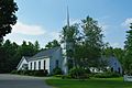
First Congregational Church
-
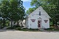
Library
-
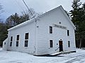
Jeremiah Smith Grange


.jpg)
See also
 In Spanish: Lee (Nuevo Hampshire) para niños
