Oyster River (New Hampshire) facts for kids
Quick facts for kids Oyster River |
|
|---|---|

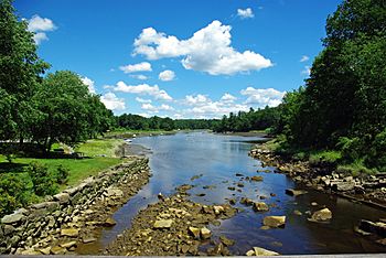
Oyster River at head of tide in Durham, New Hampshire
|
|
| Country | United States |
| State | New Hampshire |
| County | Strafford |
| Towns | Barrington, Lee, Madbury, Durham |
| Physical characteristics | |
| Main source | Creek Pond Barrington 205 ft (62 m) 43°10′3″N 71°1′58″W / 43.16750°N 71.03278°W |
| River mouth | Little Bay Durham 0 ft (0 m) 43°7′21″N 70°52′4″W / 43.12250°N 70.86778°W |
| Length | 17.0 mi (27.4 km) |
| Basin features | |
| Tributaries |
|
The Oyster River is a river about 17 miles (27 kilometers) long in Strafford County, southeastern New Hampshire, United States. It starts in Barrington and flows southeast through Lee. Then it goes east-southeast past Durham before joining Great Bay and Little Bay. These bays are connected to the Atlantic Ocean by the Piscataqua River, which is a tidal estuary. The part of the river with fresh water is about 14.1 miles (22.7 km) long. The tidal part, where ocean water mixes in, stretches for 2.9 miles (4.7 km) from Durham to Great Bay.
The Oyster River meets the ocean's tides at a dam in the center of Durham. This is just west of where NH Route 108 crosses the river. Over time, a lot of siltation (dirt and sand building up) has made it hard for boats to travel on the river. West of the Durham Water Plant, boats can only use the river for about three hours around high tide. People who use boats have noticed this problem getting worse since 1998.
Contents
History of the Oyster River
The Oyster River valley, like the rest of New England, was completely covered by a huge sheet of ice during the last Ice Age. You can still see signs of this time in the area. These include large rocks left behind by glaciers, called glacial erratics. There are also kettle holes, which are hollows formed when chunks of ice melted. One example is Spruce Hole Bog, located near the river in Durham.
How People Changed the River
Since European settlers arrived, they have changed the Oyster River and used its natural resources. In the 1600s, before people had a big impact, Great Bay was a busy port. Large ships could anchor at a spot called Durham Landing. But as more settlers came, they built dams and cut down forests to create farmland. Without tree roots to hold the soil, dirt washed into the river. This caused the river to fill with silt. By the 1800s, large ships could only reach Durham Landing during very high tides.
The Raid on Oyster River
The Oyster River community was one of the first three settlements in the Dover area. The population of this settlement grew to about 300 people in the mid-1600s. However, the community faced a difficult event in 1694. A group of Native Americans, led by French commanders, attacked the settlement. This event is known as the Raid on Oyster River. During the raid, about 94 people were either killed or taken captive.
Mill Pond Dam History
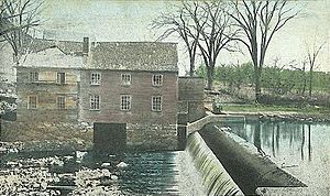
The Oyster River flows over the Mill Pond Dam near NH Route 108 in Durham. This is where the river meets the ocean's tides. The current dam was built in 1913. It is listed on the New Hampshire State Register of Historic Places as the Oyster River Dam. Before this dam, wooden dams had been in place since the mid-1600s. These older dams provided power for sawmills (to cut wood) and gristmills (to grind grain).
For several years, people discussed removing the dam. This was because of the high cost of potential repairs and concerns about water quality in Mill Pond. In November 2020, experts suggested that the dam should either be removed or made stronger. They warned that doing nothing could lead to a safety problem for the community. In January 2021, news reports estimated that strengthening the dam would cost about $4 million, while removing it would cost around $1.3 million. In September 2021, the Durham town council voted to remove the dam. Then, in March 2022, people in the town voted again and supported the decision to remove the dam.
Water Use and Importance
The Oyster River is a very important source of drinking water. It provides water for the town of Durham and the University of New Hampshire. As more people move into the area, the demand for water from the Oyster River is growing. It was expected that residential water use would increase by 54% from 2003 to 2025. Water use for businesses, industries, and irrigation was also expected to increase by 62%. This means the Oyster River is becoming an even more vital resource for the community.
Protecting the River and its Wildlife
The river flows under the busy U.S. Route 4 in three different places in Lee. It also passes close to the busy Lee Traffic Circle. This closeness to roads can be a problem if runoff (water flowing off roads) gets into the river. This runoff can carry pollution and harm the river's environment.
Along the river, there are still large areas of untouched floodplain and forests. These areas can stretch for almost 100 acres (40 hectares). Floodplains are very helpful because they hold extra water during heavy storms. This helps to reduce damage to buildings and roads along the river. These floodplains are also home to many different kinds of plants and animals that live in New Hampshire.
Wildlife in the Oyster River
One species that has been greatly affected by the river's health is the oyster itself. Due to siltation and water pollution, the number of oysters in the river reached a very low point in 2000. However, the population started to recover a couple of years later.
Another special animal that lives in the Oyster River is the American Brook Lamprey (Lampetra appendix). This fish is unique because the Oyster River is the only place in the entire state of New Hampshire where it lives. Overall, the river is home to seven different fish species that are considered important for conservation.
See also
 | Emma Amos |
 | Edward Mitchell Bannister |
 | Larry D. Alexander |
 | Ernie Barnes |


