
Wakefield, New Hampshire facts for kids
Quick facts for kids
Wakefield, New Hampshire
|
|
|---|---|
|
Town
|
|

|
|

Location in Carroll County, New Hampshire
|
|
| Country | United States |
| State | New Hampshire |
| County | Carroll |
| Incorporated | 1774 |
| Villages |
|
| Area | |
| • Total | 44.9 sq mi (116.3 km2) |
| • Land | 39.6 sq mi (102.6 km2) |
| • Water | 5.3 sq mi (13.6 km2) 11.71% |
| Elevation | 680 ft (210 m) |
| Population
(2020)
|
|
| • Total | 5,201 |
| • Density | 131/sq mi (50.7/km2) |
| Time zone | UTC-5 (Eastern) |
| • Summer (DST) | UTC-4 (Eastern) |
| ZIP codes | |
| Area code(s) | 603 |
| FIPS code | 33-78180 |
| GNIS feature ID | 0873743 |
Wakefield is a town located in Carroll County, New Hampshire, in the United States. In 2020, about 5,201 people lived here.
The town includes several small communities called villages. These are Wakefield Corner, East Wakefield, North Wakefield, Sanbornville, Union, Woodman, and Province Lake. Wakefield Corner is a very pretty village on a hill with many old buildings. It is popular with people who visit the area. The state of Maine is located to the east of Wakefield.
Contents
History of Wakefield
Early Settlement and Naming
Long ago, Native American people lived in the area that is now Wakefield. During a conflict called Father Rale's War, a person named John Lovewell attacked the settlement.
Later, settlers from Dover and Somersworth moved here. In 1749, John Mason officially granted the land for the town. It was first called "East Town." In 1774, Governor John Wentworth officially made it a town and named it Wakefield. The name came from Wakefield in Yorkshire, England. This English town is close to Wentworth Castle, which was the home of Governor Wentworth's ancestors.
Growth and Industries
Wakefield became an important stop for travelers. People used sledges and stagecoaches to travel between the seacoast and the White Mountains. The Wakefield Inn, built in 1804, was a popular place for travelers to stay. It is still open today.
Even though the soil was difficult to farm, local farmers worked hard to make it productive. Lumber became a very important product for the town. By 1859, there were five sawmills. These mills cut wood into boards. There were also five gristmills, which ground grain into flour. Many mills also made shingles, clapboards, and planed wood. Shoemaking was another important business in Wakefield.
In 1871, the Portsmouth, Great Falls and Conway Railroad arrived in town. This changed where the main part of Wakefield was. The center of town moved from Wakefield Corner to Sanbornville. Today, Sanbornville is still the main shopping area of Wakefield.
-
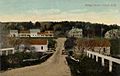
Bridge Street in 1916 (Union)
-
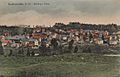
Bird's-eye View in 1908 (Sanbornville)
-
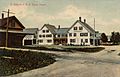
Davis House Inn in 1909 (East Wakefield)
-
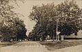
Main Street in 1909


Geography of Wakefield
Land and Water Areas
According to the United States Census Bureau, Wakefield covers a total area of about 116.3 square kilometers (44.9 square miles). Out of this, 102.6 square kilometers (39.6 square miles) is land. The remaining 13.6 square kilometers (5.3 square miles) is water. This means that about 11.71% of the town is covered by water.
Rivers and Lakes
Wakefield is where several river systems begin. The Pine River starts in the northwestern part of town. It flows northwest into Ossipee Lake. Pine River Pond in Wakefield is where the Pine River begins.
The northernmost part of town includes Province Lake. This lake flows north into the South River. Belleau Lake and Balch Pond are in the northeastern part of town. They flow east into the Little Ossipee River in Maine. All these rivers eventually lead to the Saco River.
Great East Lake is in the southeastern part of Wakefield and also extends into Maine. The water from this lake flows into the Salmon Falls River. This river forms the border between New Hampshire and Maine. Lovell Lake, in the south-central part of town, flows west into the Branch River. This river then flows south and joins the Salmon Falls River. The Salmon Falls River eventually reaches the Atlantic Ocean at Portsmouth.
Some of Wakefield's lakes, like Province, Balch, Great East, and Horn Pond, are partly in Maine. The highest point in Wakefield is the top of Long Mountain. It is about 1110 feet (338 meters) above sea level.
Villages and Roads
There are five main villages within Wakefield:
- Sanbornville is the largest village. It is located at the west end of Lovell Lake. Major roads like New Hampshire Routes 109 and 153 meet here. Route 16 goes around the west side of the village.
- Wakefield village (also called "Wakefield Corner") is on a hill just north of Sanbornville, along Route 153.
- Union is in the southernmost part of the town. It is where Route 153 and Route 16 meet.
- East Wakefield is on Route 153. It includes the land east of Pine River Pond.
- North Wakefield is along Route 16, on the west side of Pine River Pond.
Neighboring Towns and Cities
Wakefield shares its borders with several other towns and cities:
- To the north: Effingham
- To the northeast: Parsonsfield, Maine
- To the east: Newfield, Maine and Acton, Maine
- To the south: Milton
- To the southwest: Middleton
- To the west: Brookfield
- To the northwest: Wolfeboro and Ossipee
Population Changes
| Historical population | |||
|---|---|---|---|
| Census | Pop. | %± | |
| 1790 | 646 | — | |
| 1800 | 835 | 29.3% | |
| 1810 | 1,166 | 39.6% | |
| 1820 | 1,518 | 30.2% | |
| 1830 | 1,470 | −3.2% | |
| 1840 | 1,596 | 8.6% | |
| 1850 | 1,405 | −12.0% | |
| 1860 | 1,478 | 5.2% | |
| 1870 | 1,185 | −19.8% | |
| 1880 | 1,392 | 17.5% | |
| 1890 | 1,528 | 9.8% | |
| 1900 | 1,645 | 7.7% | |
| 1910 | 1,543 | −6.2% | |
| 1920 | 1,335 | −13.5% | |
| 1930 | 1,186 | −11.2% | |
| 1940 | 1,158 | −2.4% | |
| 1950 | 1,267 | 9.4% | |
| 1960 | 1,223 | −3.5% | |
| 1970 | 1,420 | 16.1% | |
| 1980 | 2,237 | 57.5% | |
| 1990 | 3,057 | 36.7% | |
| 2000 | 4,252 | 39.1% | |
| 2010 | 5,078 | 19.4% | |
| 2020 | 5,201 | 2.4% | |
| U.S. Decennial Census | |||
The number of people living in Wakefield has changed over many years. In 1790, there were 646 people. By 2020, the population had grown to 5,201.
Demographics in 2000
In 2000, there were 4,252 people living in Wakefield. These people lived in 1,685 households, and 1,213 of these were families. The population density was about 108.1 people per square mile (41.7 people per square kilometer).
Most of the people in Wakefield were White (98.21%). A small number were African American (0.09%), Native American (0.45%), or Asian (0.19%). About 0.87% of people were from two or more races. Hispanic or Latino people made up 0.56% of the population.
About 31.0% of households had children under 18 living with them. Most households (60.1%) were married couples living together. About 21.8% of all households had only one person living in them. And 10.3% of households had someone aged 65 or older living alone.
The average household had 2.52 people, and the average family had 2.92 people.
Age and Income
The population in Wakefield was spread out by age. About 25.7% of people were under 18 years old. About 15.0% were 65 years or older. The average age in town was 40 years.
In 2000, the median income for a household was $42,500. For a family, the median income was $45,774. The average income per person in the town was $21,507. About 7.1% of all people in Wakefield lived below the poverty line. This included 8.9% of those under 18 and 5.8% of those 65 or older.
Notable People from Wakefield
Many interesting people have come from Wakefield, New Hampshire. Here are a few:
- Melissa Fifield (born 1992), a racing car driver.
- Joshua G. Hall (1828–1898), who served as a US congressman.
- Joseph Kenney (born 1960), a member of the Executive Council of New Hampshire.
- Harry Libbey (1843–1913), another US congressman.
- Freddy Meyer (born 1981), a hockey player who played defense for four NHL teams.
- William Nathaniel Rogers (1892–1945), also a US congressman.
- George A. Wentworth (1835–1906), a teacher and writer of school textbooks.
See also
 In Spanish: Wakefield (Nuevo Hampshire) para niños
