
Parsonsfield, Maine facts for kids
Quick facts for kids
Parsonsfield, Maine
|
|
|---|---|

East Parsonsfield in 1917
|
|

Parsonsfield, Maine
Location in Maine
|
|
| Country | United States |
| State | Maine |
| County | York |
| Incorporated | 1785 |
| Area | |
| • Total | 59.91 sq mi (155.17 km2) |
| • Land | 58.89 sq mi (152.52 km2) |
| • Water | 1.02 sq mi (2.64 km2) |
| Elevation | 846 ft (258 m) |
| Population
(2020)
|
|
| • Total | 1,791 |
| • Density | 30/sq mi (11.7/km2) |
| Time zone | UTC-5 (Eastern (EST)) |
| • Summer (DST) | UTC-4 (EDT) |
| ZIP code |
04047
|
| Area code(s) | 207 |
| FIPS code | 23-56870 |
| GNIS feature ID | 0582662 |
Parsonsfield is a small town located in York County, Maine, in the United States. In 2020, about 1,791 people lived there. Parsonsfield is made up of several smaller communities, including the villages of Kezar Falls, Parsonsfield, and North, East, and South Parsonsfield. It is part of the larger Portland area.
Contents
History of Parsonsfield
How Parsonsfield Started
The land where Parsonsfield is now was once part of a very large area. On November 28, 1668, a Native American chief named Sunday (from the Newichewannock tribe) sold this land. He sold it to Francis Small, a trader from Kittery. The price was two large blankets, two gallons of rum, two pounds of gunpowder, four pounds of musket balls, and twenty strings of Indian beads.
Later, Francis Small sold half of his share to Major Nicholas Shapleigh. In 1771, the people who inherited the land sold it to Thomas Parsons and 39 other people. They then divided the land into lots that were about 100 acres (0.4 square kilometers) each.
Early Settlers and Town Name
The area was first called Parsonstown Plantation. In 1772, 12 families moved there and started to settle the land. On August 29, 1785, the community officially became a town. It was named Parsonsfield after Thomas Parsons, who was one of the main owners of the land.
Important Buildings and Schools
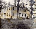
The Blazo-Leavitt House, a beautiful building in the Federal style, was built in 1812. It is a great example of old architecture.
Parsonsfield Seminary was a school founded in 1832. A seminary is a type of school, often for religious studies or higher education. This school helped educate many people in the area until it closed in 1949.
Farming and Mills in the Past
The land in Parsonsfield is hilly and rocky, but it was good for farming. Farmers mainly grew grain and hay. People built mills near ponds and on the South River. These mills used the power of flowing water to grind grain or saw wood.
The biggest source of water power was on the Ossipee River at Kezar Falls. The village of Kezar Falls grew around this area. Parsonsfield had seven sawmills (for cutting wood) and seven gristmills (for grinding grain). In 1880, a very important business started: the Kezar Falls Woolen Mill. This factory made woolen textiles and became the most important business in Parsonsfield.
-
The Blazo-Leavitt House around 1900
-
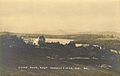
West Pond around 1915
-
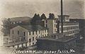
The Kezar Falls Woolen Co. mill in 1907


Geography of Parsonsfield
Land and Water Features
Parsonsfield covers about 59.91 square miles (155.17 square kilometers). Most of this area, about 58.89 square miles (152.52 square kilometers), is land. The rest, about 1.02 square miles (2.64 square kilometers), is water.
The town has two main rivers: the South River and the Ossipee River. The highest point in Parsonsfield is Wiggin Mountain, which is about 1,300 feet (396 meters) above sea level.
Neighboring Towns and Roads
Parsonsfield is connected by state roads like Route 25 and Route 160. It shares borders with several other towns:
- To the west: Effingham and Wakefield, New Hampshire
- To the north: Porter and Hiram
- To the east: Cornish and Limerick
- To the south: Newfield
Forests and Nature
About 20 percent of Parsonsfield is part of the Leavitt Plantation Forest. This is a large forest area, covering about 8,603 acres (34.8 square kilometers). It is the biggest continuous forest south of Sebago Lake.
To protect this important forest, the Nature Conservancy and the state of Maine worked together. They bought a special agreement called a "conservation easement" for the entire forest. This agreement helps protect Leavitt Plantation forever, while still allowing for careful and sustainable tree harvesting.
Population and People
| Historical population | |||
|---|---|---|---|
| Census | Pop. | %± | |
| 1790 | 654 | — | |
| 1800 | 1,350 | 106.4% | |
| 1810 | 1,763 | 30.6% | |
| 1820 | 2,355 | 33.6% | |
| 1830 | 2,492 | 5.8% | |
| 1840 | 2,442 | −2.0% | |
| 1850 | 2,322 | −4.9% | |
| 1860 | 2,125 | −8.5% | |
| 1870 | 1,894 | −10.9% | |
| 1880 | 1,613 | −14.8% | |
| 1890 | 1,398 | −13.3% | |
| 1900 | 1,131 | −19.1% | |
| 1910 | 1,057 | −6.5% | |
| 1920 | 1,062 | 0.5% | |
| 1930 | 897 | −15.5% | |
| 1940 | 946 | 5.5% | |
| 1950 | 958 | 1.3% | |
| 1960 | 869 | −9.3% | |
| 1970 | 971 | 11.7% | |
| 1980 | 1,089 | 12.2% | |
| 1990 | 1,472 | 35.2% | |
| 2000 | 1,584 | 7.6% | |
| 2010 | 1,898 | 19.8% | |
| 2020 | 1,791 | −5.6% | |
| U.S. Decennial Census | |||
What the 2020 Census Shows
The census is a count of all the people living in a place. In 2020, there were 1,791 people living in Parsonsfield. These people lived in 694 households, and 508 of these were families.
- Most people (94.1%) were White.
- A small number were African American (0.3%), Native American (0.5%), or Asian (0.5%).
- About 4.2% of people were from two or more races.
- People of Hispanic or Latino background made up 1.3% of the population.
About 20.6% of households had children under 18 living there. The average household had 2.48 people, and the average family had 2.92 people.
Local Schools in Parsonsfield
Students in Parsonsfield attend these schools:
- Sacopee Valley Middle School
- Sacopee Valley High School
Places to Visit in Parsonsfield
- Parsonsfield-Porter Bridge: This is a two-span covered bridge built in 1876. You can learn more about it here: Parsonsfield-Porter Bridge.
- Parsonsfield-Porter Historical Society & Museum: Located in Porter, this museum helps you learn about the history of the area. You can find more information here: Parsonsfield-Porter Historical Society & Museum.
Notable People from Parsonsfield

Many interesting people have come from Parsonsfield, including:
- James W. Bradbury: A senator.
- Contessa Brewer: A news anchor.
- Nathaniel Burbank: A journalist.
- John Buzzell: A clergyman and writer.
- Oren B. Cheney: A clergyman and educator.
- Carolyn Chute: A writer.
- Luther Orlando Emerson: A musician, composer, and music publisher.
- Charles Augustus Hilton: A preacher.
- Louise Lamprey: A writer and journalist.
- Jerry Korn: A pilot and author.
- Robert Greenleaf Leavitt: A botanist (someone who studies plants).
- Rufus McIntire: A US congressman.
- Daniel Page: A politician and businessman.
- Alzina Parson Stevens: A labor leader.
- Lorenzo De Medici Sweat: A US congressman.
- Amos Tuck: A US congressman.
Images for kids
-
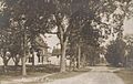
East Parsonsfield in 1917
See also
 In Spanish: Parsonsfield para niños
