Porter, Maine facts for kids
Quick facts for kids
Porter, Maine
|
|
|---|---|

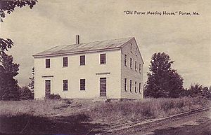
Old Porter Meeting House (built 1828), c. 1922
|
|
| Country | United States |
| State | Maine |
| County | Oxford |
| Incorporated | 1807 |
| Area | |
| • Total | 32.87 sq mi (85.13 km2) |
| • Land | 31.50 sq mi (81.58 km2) |
| • Water | 1.37 sq mi (3.55 km2) |
| Elevation | 466 ft (142 m) |
| Population
(2020)
|
|
| • Total | 1,600 |
| • Density | 51/sq mi (19.6/km2) |
| Time zone | UTC-5 (Eastern (EST)) |
| • Summer (DST) | UTC-4 (EDT) |
| ZIP code |
04068
|
| Area code(s) | 207 |
| FIPS code | 23-60405 |
| GNIS feature ID | 0582682 |
Porter is a small town in Oxford County, Maine, United States. It is part of the larger Portland-South Portland-Biddeford area. The town includes Porter village and a part of Kezar Falls. In 2020, about 1,600 people lived there.
Contents
History of Porter
The land where Porter now stands was once home to the Pequawket people, a group of the Abenaki tribe. Their village was located in what is now Fryeburg.
How Porter Got Its Name
In September 1795, a doctor named Aaron Porter from Biddeford and others bought the land. They bought it from the Massachusetts General Court, which was like the government of Massachusetts at the time. The deal offered 100 acres (about 40 hectares) to anyone who settled there before January 1, 1784.
The area was first called Portersfield Plantation. On February 20, 1807, it officially became a town. It was named Porter after Dr. Aaron Porter, who was a main owner of the land. Some land was later given to the nearby town of Brownfield in 1831, 1832, and 1855.
Early Life and Industries
Even though the land was a bit bumpy, farmers found that the hills were great for raising cattle. Porter became well-known for its orchards, where fruit trees grew.
The town also had many mills. These mills used the power of water from ponds and the Ossipee River. The best water power was at Kezar Falls. This area is partly in Porter and partly in Parsonsfield.
Porter had several sawmills, which cut wood. There was also a gristmill for grinding grain. Other factories made furniture, bobbins (parts for spinning machines), and boots and shoes. By 1870, about 1,104 people lived in Porter.
Geography of Porter
Porter covers a total area of about 32.87 square miles (85.13 square kilometers). Most of this is land, about 31.50 square miles (81.58 square kilometers). The rest, about 1.37 square miles (3.55 square kilometers), is water. The Ossipee River flows through the town.
Roads and Neighboring Towns
Two main roads, State Route 25 and State Route 160, cross through Porter.
Porter shares its borders with several other towns:
- To the west: Eaton and Freedom, New Hampshire (both in New Hampshire)
- To the north: Brownfield
- To the east: Hiram
- To the south: Parsonsfield
Population Changes in Porter
| Historical population | |||
|---|---|---|---|
| Census | Pop. | %± | |
| 1810 | 292 | — | |
| 1820 | 487 | 66.8% | |
| 1830 | 841 | 72.7% | |
| 1840 | 1,133 | 34.7% | |
| 1850 | 1,208 | 6.6% | |
| 1860 | 1,240 | 2.6% | |
| 1870 | 1,104 | −11.0% | |
| 1880 | 1,095 | −0.8% | |
| 1890 | 1,015 | −7.3% | |
| 1900 | 886 | −12.7% | |
| 1910 | 864 | −2.5% | |
| 1920 | 820 | −5.1% | |
| 1930 | 883 | 7.7% | |
| 1940 | 892 | 1.0% | |
| 1950 | 1,052 | 17.9% | |
| 1960 | 975 | −7.3% | |
| 1970 | 1,115 | 14.4% | |
| 1980 | 1,222 | 9.6% | |
| 1990 | 1,301 | 6.5% | |
| 2000 | 1,438 | 10.5% | |
| 2010 | 1,498 | 4.2% | |
| 2020 | 1,600 | 6.8% | |
| U.S. Decennial Census | |||
Population in 2010
In 2010, there were 1,498 people living in Porter. These people lived in 621 households, with 416 of them being families. The town had about 47.6 people per square mile (18.4 people per square kilometer).
The average age of people in Porter was 44.4 years old. About 20.2% of the residents were under 18 years old. About 15.5% were 65 years old or older. The population was almost evenly split between males (50.5%) and females (49.5%).
Local Schools
- Sacopee Valley Middle School
- Sacopee Valley High School
Notable People from Porter
- Samuel W. Gould: A US congressman.
- Harry Lord (1882–1948): A baseball player who played for the Boston Red Sox.
Places to Visit in Porter
- Parsonsfield-Porter Bridge: A covered bridge built in 1876.
- Parsonsfield-Porter Historical Society & Museum: A place to learn about the town's history.
- Maine Teen Camp: A summer camp for teenagers.
- Old Porter Meeting House: A historic building.
See also
 In Spanish: Porter (Maine) para niños
 | Delilah Pierce |
 | Gordon Parks |
 | Augusta Savage |
 | Charles Ethan Porter |


