
Hiram, Maine facts for kids
Quick facts for kids
Hiram, Maine
|
|
|---|---|

Great Falls, Saco River in 1869
|
|

Hiram, Maine
Location in Maine

Hiram, Maine
Location in the United States
|
|
| Country | United States |
| State | Maine |
| County | Oxford |
| Incorporated | 1814 |
| Area | |
| • Total | 38.87 sq mi (100.67 km2) |
| • Land | 37.55 sq mi (97.25 km2) |
| • Water | 1.32 sq mi (3.42 km2) |
| Elevation | 823 ft (251 m) |
| Population
(2020)
|
|
| • Total | 1,609 |
| • Density | 43/sq mi (16.5/km2) |
| Time zone | UTC-5 (Eastern (EST)) |
| • Summer (DST) | UTC-4 (EDT) |
| ZIP code |
04041
|
| Area code(s) | 207 |
| FIPS code | 23-33315 |
| GNIS feature ID | 0582520 |
Hiram is a small town in Oxford County, Maine, in the United States. About 1,609 people lived there in 2020. Hiram includes several smaller areas like East Hiram, South Hiram, and Durgintown. It is located in the beautiful Western Maine Mountains. Hiram is also part of the larger Portland metropolitan area.
Contents
History of Hiram
Hiram started as a stop for stagecoaches along the Pequawket Trail. This trail was once used by the Sokokis Abenaki people. The area was first called Great Ossipee, named after the Ossipee River.
Early Settlement and Naming
People began settling in Hiram in the 1780s. It was first set up as Hiram Plantation. The name "Hiram" comes from Hiram I, a king from the Bible who ruled a place called Tyre. Just like King Hiram's land, Hiram Plantation was surrounded by thick forests.
Hiram officially became a district on February 27, 1807. Later, on June 14, 1814, it became a full town. In 1790, a man named Peleg Wadsworth bought land here. He started a farm for his oldest son a few years later.
Farming and Early Life
Even though the center of Hiram was a bit uneven, there was good, rich farmland in the flat river valleys, called intervales. The soil was sandy loam, which is a mix of sand, silt, and clay. This soil was good for growing wheat and hay, which was the main crop. Farmers also raised sheep in the pastures. The wool from the sheep became a very important product for the town. By 1830, Hiram had a population of 1,148 people.
Industries and Growth
The Saco River and nearby ponds provided water power for mills. This made the timber industry very important. In 1859, Hiram had many businesses. These included shops where people made barrels (called cooper shops), two blacksmith shops, and places where people made shoes and harnesses.
By 1886, the town had five sawmills and planing mills. They produced different kinds of lumber, barrel staves (pieces for barrels), and shooks (barrel kits). There were also two gristmills (for grinding grain) and a carding mill (for preparing wool). Other things made in Hiram included men's clothing and slate blackboards.
Hiram was also an important railroad junction. This meant it was a place where different train lines met. The Bridgton and Saco River Railroad connected with the Portland and Ogdensburg Railroad here. This made Hiram a busy and pretty village.
-
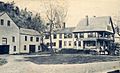
Bucknell House c. 1915, built in 1792 near the Saco River.
-
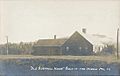
Mt. Cutler House in 1909, an early stagecoach stop and hotel.
-
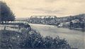
Railroad bridge across the Saco River in 1916.


Geography and Location
Hiram covers a total area of about 38.87 square miles (100.67 square kilometers). Most of this area is land, about 37.55 square miles (97.25 square kilometers). The rest, about 1.32 square miles (3.42 square kilometers), is water. The town gets its water from the Ossipee River and Saco River.
Roads and Neighboring Towns
Several state roads pass through Hiram, including Maine State Route 5, 113, 117, and 160. Hiram shares its borders with several other towns. To the north are Brownfield and Denmark. To the west is Porter. To the east are Sebago and Baldwin. To the south are Cornish and Parsonsfield.
Climate in Hiram
Hiram has a humid continental climate. This means it has big changes in temperature throughout the year. Summers are usually warm to hot and can be humid. Winters are cold, and sometimes very cold.
Population Facts
| Historical population | |||
|---|---|---|---|
| Census | Pop. | %± | |
| 1790 | 92 | — | |
| 1800 | 184 | 100.0% | |
| 1810 | 336 | 82.6% | |
| 1820 | 700 | 108.3% | |
| 1830 | 1,026 | 46.6% | |
| 1840 | 1,233 | 20.2% | |
| 1850 | 1,210 | −1.9% | |
| 1860 | 1,283 | 6.0% | |
| 1870 | 1,393 | 8.6% | |
| 1880 | 1,452 | 4.2% | |
| 1890 | 1,063 | −26.8% | |
| 1900 | 1,015 | −4.5% | |
| 1910 | 945 | −6.9% | |
| 1920 | 921 | −2.5% | |
| 1930 | 813 | −11.7% | |
| 1940 | 787 | −3.2% | |
| 1950 | 804 | 2.2% | |
| 1960 | 699 | −13.1% | |
| 1970 | 686 | −1.9% | |
| 1980 | 1,067 | 55.5% | |
| 1990 | 1,260 | 18.1% | |
| 2000 | 1,423 | 12.9% | |
| 2010 | 1,620 | 13.8% | |
| 2020 | 1,609 | −0.7% | |
| U.S. Decennial Census | |||

Hiram's Population in 2010
In 2010, there were 1,620 people living in Hiram. These people lived in 652 different homes, and 432 of these were families. The population density was about 43.1 people per square mile. This means that, on average, there were 43.1 people living in each square mile of land.
Most of the people in Hiram were White (95.7%). A small number were from other racial backgrounds. About 0.7% of the population identified as Hispanic or Latino.
In terms of homes, about 31.4% of them had children under 18 living there. About half of the homes (50.6%) were married couples living together. The average home had 2.48 people, and the average family had 3 people. The median age in Hiram was 41.3 years old. This means half the people were older than 41.3, and half were younger.
Local Schools
- Sacopee Valley Middle School
- Sacopee Valley High School
Notable People from Hiram
- Contessa Brewer, a news anchor for MSNBC.
- Charles Cleaves Cole, a federal judge.
- Henry Wadsworth Longfellow, a famous poet.
- Peleg Wadsworth, a general who helped found Hiram.
See also
 In Spanish: Hiram (Maine) para niños
