
Brownfield, Maine facts for kids
Quick facts for kids
Brownfield, Maine
|
|
|---|---|

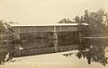
East Brownfield in 1908
|
|

Brownfield, Maine
Location in Maine

Brownfield, Maine
Location in the United States
|
|
| Country | United States |
| State | Maine |
| County | Oxford |
| Incorporated | 1802 |
| Area | |
| • Total | 45.45 sq mi (117.71 km2) |
| • Land | 44.47 sq mi (115.18 km2) |
| • Water | 0.98 sq mi (2.54 km2) |
| Elevation | 528 ft (161 m) |
| Population
(2020)
|
|
| • Total | 1,631 |
| • Density | 37/sq mi (14.2/km2) |
| Time zone | UTC-5 (Eastern (EST)) |
| • Summer (DST) | UTC-4 (EDT) |
| ZIP code |
04010
|
| Area code(s) | 207 |
| FIPS code | 23-08150 |
| GNIS feature ID | 0582373 |
Brownfield is a small town located in Oxford County, Maine, United States. In 2020, about 1,631 people lived there. Brownfield is also home to the Stone Mountain Arts Center, a place for music and art.
Contents
History

Early Settlement and Naming
Long ago, the land where Brownfield now stands belonged to the Pequawket Abenaki Indians. Their main village was in what is now Fryeburg.
In 1764, the land was given to Captain Henry Young Brown. This was a reward for his help in the French and Indian Wars. People started settling here around 1765. Captain Brown had to get 38 families to live there by 1770.
Part of the original land grant was actually in New Hampshire. So, Captain Brown received new land in Maine in 1766. This new area was called Brownfield Addition. Some of it is now part of Hiram and Denmark.
Becoming a Town
The area was first organized as Brownfield Plantation. It was named to honor Captain Brown. On February 20, 1802, Brownfield officially became an incorporated town. This means it was recognized as a self-governing community. By the time of the War of 1812, nearly 900 people lived in Brownfield.
Life and Industry
Farming was the main way people made a living. The Saco River was very important because it provided water power for mills. These mills made many things, like flour, lumber, barrels, rocking chairs, and even carriages.
After the Civil War, the Portland and Ogdensburg Railroad was built through the town. It followed the path of the Saco River. This made it easier to transport goods and people.
The Great Fires and Later Years
In 1947, a terrible event happened: the Great Fires of 1947. These fires destroyed a huge part of Brownfield, about 85% of the town.
To help the town recover, a ski resort was planned on Burnt Meadow Mountain. It opened in 1971 but closed in 1982. Today, you can still see the old T-bar lifts there.
In 2002, Brownfield celebrated its 200th anniversary as an incorporated town.
Geography
Brownfield is located right next to the New Hampshire border. The town covers about 45.45 square miles (117.71 square kilometers). Most of this area is land, with a small part being water. The Saco River flows through Brownfield.
Demographics
| Historical population | |||
|---|---|---|---|
| Census | Pop. | %± | |
| 1790 | 146 | — | |
| 1800 | 287 | 96.6% | |
| 1810 | 388 | 35.2% | |
| 1820 | 747 | 92.5% | |
| 1830 | 936 | 25.3% | |
| 1840 | 1,360 | 45.3% | |
| 1850 | 1,320 | −2.9% | |
| 1860 | 1,398 | 5.9% | |
| 1870 | 1,323 | −5.4% | |
| 1880 | 1,229 | −7.1% | |
| 1890 | 1,134 | −7.7% | |
| 1900 | 1,019 | −10.1% | |
| 1910 | 933 | −8.4% | |
| 1920 | 835 | −10.5% | |
| 1930 | 689 | −17.5% | |
| 1940 | 741 | 7.5% | |
| 1950 | 612 | −17.4% | |
| 1960 | 538 | −12.1% | |
| 1970 | 478 | −11.2% | |
| 1980 | 767 | 60.5% | |
| 1990 | 1,034 | 34.8% | |
| 2000 | 1,251 | 21.0% | |
| 2010 | 1,597 | 27.7% | |
| 2020 | 1,631 | 2.1% | |
| U.S. Decennial Census | |||

In 2010, there were 1,597 people living in Brownfield. There were 662 households, which are groups of people living together. Most of the people living in Brownfield were White. The average age of people in Brownfield was about 44.8 years old.
Sites of interest
- Brownfield Historical Society & Museum
- Stone Mountain Arts Center
Notable people
- Philo T. Farnsworth, inventor
- Paris Gibson, entrepreneur, senator
- Robert Goodenow, US congressman
- Rufus K. Goodenow, US congressman
- Carol Noonan, singer and songwriter
- Augustus G. Paine, Sr., financier
Images for kids
-
Saco River at East Brownfield around 1912
-
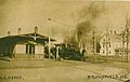
M.C.R.R. depot in 1912, East Brownfield
-
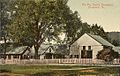
Breslin homestead around 1910


See also
 In Spanish: Brownfield (Maine) para niños
