
Fryeburg, Maine facts for kids
Quick facts for kids
Fryeburg, Maine
|
|
|---|---|

|
|
| Motto(s):
"The Oldest Town in Oxford County"
|
|

Fryeburg, Maine
Location in Maine

Fryeburg, Maine
Location in the United States
|
|
| Country | United States |
| State | Maine |
| County | Oxford |
| Incorporated | 1777 |
| Named for | Joseph Frye |
| Area | |
| • Total | 65.89 sq mi (170.65 km2) |
| • Land | 58.33 sq mi (151.07 km2) |
| • Water | 7.56 sq mi (19.58 km2) |
| Population
(2020)
|
|
| • Total | 3,369 |
| • Density | 58/sq mi (22.3/km2) |
| Time zone | UTC-5 (Eastern (EST)) |
| • Summer (DST) | UTC-4 (EDT) |
| ZIP Code |
04037
|
| Area code(s) | 207 |
Fryeburg is a town in Oxford County, Maine, in the United States. In 2020, about 3,369 people lived there.
Fryeburg is known for a few special places. It's home to Fryeburg Academy, which is a school that helps students get ready for college. It also has the International Musical Arts Institute. Every October, the town hosts the Fryeburg Fair, which is a huge event that brings in around 300,000 visitors!
Contents
History of Fryeburg
Early Days: Native American Village
Long ago, the area where Fryeburg is now was a big village for the Abenaki people. They called it Pequawket. This name meant "crooked place," because of a large bend in the Saco River. The Sokokis tribe lived here. Their land stretched from the coast at Saco all the way to the White Mountains in New Hampshire.
In 1706, a Native American leader named Chief Nescambious was honored by the French. For a while, the Sokokis tribe got along with the English settlers. They even hired British builders to construct a tall wooden fort to protect them from their enemies, the Mohawks. In 1713, the Sokokis leaders signed the Treaty of Portsmouth to keep peace with the English.
However, things eventually changed, and relations became difficult. During Father Rale's War, there was a battle at Pequawket on May 8, 1725. John Lovewell and his soldiers attacked the village. Both Lovewell and Chief Paugus were killed. After this battle, the tribe left the village and moved to Canada.
Founding the Town
On March 3, 1762, the land was given to Colonel Joseph Frye from Massachusetts. The settlers called it Pigwacket, which was a changed version of the old Native American name. The first people to live there permanently arrived in 1763. Nathaniel Smith and his family came from New Hampshire. Some say that John Stevens, Nathaniel Merrill, and a slave named Limbo spent the winter there even earlier, in 1762. Many of the first settlers were soldiers who had fought in the French and Native Wars.
Part of the land grant was actually in New Hampshire. So, new land was given to Fryeburg, which is now part of Stow. Just before America became independent, Fryeburg was officially given town rights. This was confirmed on January 11, 1777, when Fryeburg became an incorporated town.
Growth and Development
Fryeburg started as an important outpost on the edge of settled lands. It was the first town in the White Mountain area. The soil was very good, which helped Fryeburg become a successful farming town. The first gristmill (a mill for grinding grain) was built in 1766, using the power of the Saco River. Other factories and mills made things like lumber, leather, harness, and canned vegetables.
After the Civil War, a railroad came through town. This brought tourists who wanted to escape the hot, busy cities. Many inns, hotels, and boarding houses were built for them. Later, in 1919, tourists started arriving by car when the Theodore Roosevelt International Highway was created. Today, this road is known as United States Route 302.
Fryeburg is now a popular place to visit all year round. It's also an important town for education. Fryeburg Academy, a private school, was founded in 1792. A famous politician named Daniel Webster taught there for a year before he became a statesman. In 1924, Dr. Abraham Krasker started Indian Acres Camp For Boys. Two years later, his wife Gertrude started Forest Acres Camp For Girls. In 1997, the International Musical Arts Institute was also founded in Fryeburg.
Geography
Fryeburg covers about 65.89 square miles (170.65 square kilometers). Most of this area is land, and about 7.56 square miles (19.58 square kilometers) is water. The town is located right next to the New Hampshire border. The Saco River flows through Fryeburg.
Major roads that serve the town include U.S. Route 302, Maine State Route 5, and Maine State Route 113.
Climate
Fryeburg has a climate with big differences between seasons. Summers are warm to hot and often humid. Winters are cold, and sometimes very cold. This type of weather is called a humid continental climate.
Population Information
| Historical population | |||
|---|---|---|---|
| Census | Pop. | %± | |
| 1810 | 1,004 | — | |
| 1820 | 1,057 | 5.3% | |
| 1830 | 1,352 | 27.9% | |
| 1840 | 1,536 | 13.6% | |
| 1850 | 1,523 | −0.8% | |
| 1860 | 1,623 | 6.6% | |
| 1870 | 1,507 | −7.1% | |
| 1880 | 1,633 | 8.4% | |
| 1890 | 1,418 | −13.2% | |
| 1900 | 1,376 | −3.0% | |
| 1910 | 1,282 | −6.8% | |
| 1920 | 1,283 | 0.1% | |
| 1930 | 1,592 | 24.1% | |
| 1940 | 1,726 | 8.4% | |
| 1950 | 1,926 | 11.6% | |
| 1960 | 1,874 | −2.7% | |
| 1970 | 2,208 | 17.8% | |
| 1980 | 2,715 | 23.0% | |
| 1990 | 2,968 | 9.3% | |
| 2000 | 3,083 | 3.9% | |
| 2010 | 3,449 | 11.9% | |
| 2020 | 3,369 | −2.3% | |
| U.S. Decennial Census | |||
In 2010, there were 3,449 people living in Fryeburg. There were 1,368 households, and 920 families. About 30.8% of households had children under 18. The average age of people in Fryeburg was 44 years old.
Fun Places to Visit
- Jockey Cap Rock is a large granite rock near the Saco River. It was left there by a glacier. The famous Arctic explorer Robert Peary lived in Fryeburg for a short time. He made a map of the hills and mountains you can see from the top of this rock. Later, a bronze monument was placed there in his memory in 1938. You can hike a short trail (about half a mile) to the top of the rock to see it.
- Fryeburg Fair Farm Museum
- Fryeburg Historical Society & Museum
Education
Fryeburg is part of Maine School Administrative District #72. Jay Robinson is the current Superintendent.
Schools in this district include Brownfield-Denmark, Molly Ockett, New Suncook School, and Fryeburg Academy.
Transportation and Business
U.S. Route 302 in Fryeburg is a very important road. It's the second largest entry point for cars coming into Maine, after Interstate 95 in Kittery.
The town also has a small airport called Eastern Slopes Regional Airport. Fryeburg is home to some businesses like Dearborn Precision Tubular Products, which makes special metal tubes. Har-Mac Steel is another company that makes materials for building things like tunnels, bridges, and large buildings.
Notable people
- Anna Barrows, cooking expert
- Charles S. Benton, US congressman
- Nathaniel S. Benton, politician
- John W. Dana, governor of Maine
- Judah Dana, US senator
- Joseph Frye, military leader and founder
- Spalding Gray, actor and author
- David Hastings, state senator
- Caroline Dana Howe, writer
- Eastman Johnson, artist
- Jigger Johnson, logger
- Clarence E. Mulford, creator of Hopalong Cassidy
- Nescambious, Abenaki tribal chief
- James R. Osgood, publisher
- Robert Peary, Arctic explorer
- James W. Ripley, US congressman
- Eric Rosenblith, violinist
- Mark Walker, state legislator
- Daniel Webster, US senator and secretary of state
- James S. Wiley, US congressman
Images for kids
-
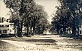
Main Street around 1910
-
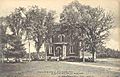
Fryeburg Academy in 1913
-
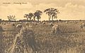
Intervale around 1920


See also
 In Spanish: Fryeburg (Maine) para niños
