
Cornish, Maine facts for kids
Quick facts for kids
Cornish, Maine
|
|
|---|---|

Downtown Cornish
|
|
| Nickname(s):
The Crown of York County
|
|
| Motto(s):
"Come & Explore Your Next Cherished Memory"
|
|

Cornish, Maine
Location in Maine
|
|
| Country | United States |
| State | Maine |
| County | York |
| Incorporated | 1794 |
| Area | |
| • Total | 22.38 sq mi (57.96 km2) |
| • Land | 22.18 sq mi (57.45 km2) |
| • Water | 0.20 sq mi (0.52 km2) |
| Elevation | 351 ft (107 m) |
| Population | |
| • Total | 1,508 |
| • Density | 68/sq mi (26.2/km2) |
| Time zone | UTC-5 (Eastern (EST)) |
| • Summer (DST) | UTC-4 (EDT) |
| ZIP code |
04020
|
| Area code(s) | 207 |
| FIPS code | 23-14485 |
| GNIS feature ID | 0582421 |
Cornish is a small and friendly town located in York County, Maine, in the United States. In 2020, about 1,508 people called Cornish home. It's part of the larger Portland area.
The main part of town, known as Cornish village, is a charming place. You can find many antique shops and restaurants there. These are all close to the historic Thompson Park. Cornish is also special because it has the first concrete bridge ever built in North America!
Contents
Cornish's Early History
In 1665, a special place called a trading post was set up near where Cornish village is today. It was close to where the Ossipee River meets the Saco River. This spot was important because three main Abenaki Native American paths met there. These paths were the Sokokis Trail (Route 5), the Ossipee Trail (Route 25), and the Pequawket Trail (Route 113). This made it a perfect spot for trading valuable furs with Native Americans.
In 1668, a man named Francis Small bought a large area of land from Chief Captain Sunday. This land included what is now Cornish and several other towns. He paid for the land with items like blankets, rum, gunpowder, musket balls, and Indian beads.
Years later, in 1770, Francis Small's family found the old land deed. They hired a lawyer named James Sullivan to help them claim the land. They won their case! As payment, Sullivan received a township he named Limerick. Small's family then took control of other areas, including Cornish.
Cornish was first called Francisborough, then Francistown, after Francis Small. Joseph Thompson settled there in 1782. On February 27, 1794, it officially became a town and was named Cornish. This name likely came from settlers who moved there from Cornwall, England. The land was great for farming, especially for growing corn and other grains. By 1859, about 1,144 people lived in Cornish. In the early 1870s, the Portland and Ogdensburg Railroad came through the Saco River valley, helping the town grow.
Where is Cornish Located?
Cornish covers about 22.38 square miles (57.96 square kilometers) of land. Most of this is dry land, with a small amount of water. The town gets its water from the Ossipee River and the Saco River.
The highest point in Cornish is Clark Mountain, which is over 1,320 feet (402 meters) above sea level. This mountain is also the highest point in all of York County! Another tall spot is Hosac Mountain, which is 1,320 feet (402 meters) high.
Cornish is connected by several state roads, including Route 5, Route 25, and Route 160. It shares its borders with several other towns: Hiram to the north, Baldwin to the northeast, Limington to the east, Limerick to the south, and Parsonsfield to the west.
Cornish Population Facts

The number of people living in Cornish has changed over time. Here's a look at how the population has grown:
| Historical population | |||
|---|---|---|---|
| Census | Pop. | %± | |
| 1790 | 409 | — | |
| 1800 | 734 | 79.5% | |
| 1810 | 971 | 32.3% | |
| 1820 | 1,088 | 12.0% | |
| 1830 | 1,235 | 13.5% | |
| 1840 | 1,263 | 2.3% | |
| 1850 | 1,144 | −9.4% | |
| 1860 | 1,153 | 0.8% | |
| 1870 | 1,100 | −4.6% | |
| 1880 | 1,169 | 6.3% | |
| 1890 | 1,118 | −4.4% | |
| 1900 | 984 | −12.0% | |
| 1910 | 954 | −3.0% | |
| 1920 | 813 | −14.8% | |
| 1930 | 753 | −7.4% | |
| 1940 | 826 | 9.7% | |
| 1950 | 795 | −3.8% | |
| 1960 | 816 | 2.6% | |
| 1970 | 839 | 2.8% | |
| 1980 | 1,047 | 24.8% | |
| 1990 | 1,178 | 12.5% | |
| 2000 | 1,269 | 7.7% | |
| 2010 | 1,403 | 10.6% | |
| 2020 | 1,508 | 7.5% | |
| U.S. Decennial Census | |||
According to the 2010 census, there were 1,403 people living in Cornish. Most residents were White. The average age in town was about 44.5 years old.
Schools in Cornish
Cornish has been home to several schools over the years:
- Cornish Elementary (This school is now closed)
- Sacopee Valley Middle School
- Sacopee Valley High School
Places to Visit in Cornish
If you visit Cornish, here are some interesting places you might want to see:
- Cornish Historical Society & Museum
- Saco River Festival Association
- Caleb R. Ayer House
- George F. Clifford House
- Odd Fellows-Rebekah Hall
- LeRoy F. Pike Memorial Building
Famous People from Cornish
Several notable people have connections to Cornish:
- Caleb R. Ayer: A state senator and Secretary of State in the 1800s.
- David Dunn: The 18th governor of Maine.
- Eddie Files: A baseball pitcher.
- David Hammons: A US congressman.
- Joseph Hammons: Another US congressman, but from New Hampshire.
- Steve Letarte: A former crew chief for NASCAR driver Dale Earnhardt Jr. He is now a commentator for NASCAR on NBC.
Cornish in Popular Culture
Cornish is briefly mentioned in Stephen King's 1975 novel 'Salem's Lot.
Images for kids
-
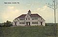
Old High School in 1915

See also
 In Spanish: Cornish (Maine) para niños
