
Limerick, Maine facts for kids
Quick facts for kids
Limerick, Maine
|
||
|---|---|---|

Main Street (Sokokis Trail)
|
||
|
||

Limerick, Maine
Location in Maine
|
||
| Country | United States | |
| State | Maine | |
| County | York | |
| Settled | 1775 | |
| Incorporated | March 6, 1787 | |
| Area | ||
| • Total | 28.25 sq mi (73.17 km2) | |
| • Land | 27.14 sq mi (70.29 km2) | |
| • Water | 1.11 sq mi (2.87 km2) | |
| Elevation | 469 ft (143 m) | |
| Population
(2020)
|
||
| • Total | 3,188 | |
| • Density | 118/sq mi (45.4/km2) | |
| Time zone | UTC-5 (Eastern (EST)) | |
| • Summer (DST) | UTC-4 (EDT) | |
| ZIP code |
04048
|
|
| Area code(s) | 207 | |
| FIPS code | 23-39195 | |
| GNIS feature ID | 0582556 | |
| Website | www.limerick-me.gov | |

Limerick (pronounced "LIM-rick") is a town in York County, Maine, United States. It is part of the larger metropolitan area that includes Portland. In 2020, about 3,188 people lived there.
Contents
History of Limerick
Early Settlement and Native Americans
The land where Limerick is now was once home to the Newichewannock Abenaki people. Their village was located by the Salmon Falls River. In 1668, a trader named Francis Small bought a large area of land from Chief Captain Sunday. He traded things like blankets, rum, gunpowder, and beads for the land. Small then sold half of his land to Major Nicholas Shapleigh, a very rich merchant.
Becoming a Town
Settling the area took a long time because of ongoing wars. These were called the French and Indian Wars. They finally ended in 1763 with the Treaty of Paris. In 1773, the families of Francis Small and Nicholas Shapleigh offered land to a lawyer named James Sullivan. He would get a whole township if he helped them with their land claims.
Sullivan agreed and in 1775, he helped start Limerick Plantation. It was named after Limerick in Ireland, which was his father's birthplace. The town officially became incorporated on March 6, 1787. One of the first people to settle there was Dr. Joshua Leavitt. A stream in Limerick, Leavitt Brook, is named after him. Later, people from Limerick, Maine, settled a new town called New Limerick in Aroostook County.
Growth and Industries
Limerick village grew along an old path called the Sokokis Trail. Today, this path is Route 5. It connected two Native American villages. Limerick had good soil, which helped it become a successful farming community. Farmers grew crops like hay, apples, grapes, and cranberries. Raising cattle and making dairy products were also important.
The town also had many small businesses. There were shops for blacksmiths, shoemakers, and hatmakers. People also made harnesses and processed leather at tanneries. Local streams provided water power for factories. These included four furniture factories and a clothing factory. There were also mills for grinding grain, making shingles, and cutting lumber.
In 1826, a newspaper called The Morning Star started in Limerick. It was a Free Will Baptist newspaper that spoke out against slavery. Later, in 1846, James Bradbury started the Limerick Manufacturing Company. This company was bought by Joshua Holland in 1857. His company made famous Holland Blankets. These blankets were even given to soldiers during the Civil War. A small village called Hollandville grew up around the mill.
Geography and Nature
Limerick is a town with many hills and lakes. It covers about 28.25 square miles (73.17 square kilometers). Most of this area is land, about 27.14 square miles (70.29 square kilometers). The rest, about 1.11 square miles (2.87 square kilometers), is water. Several streams flow through Limerick, including Leavitt Brook, Brown Brook, and Spencer Brook.
Limerick shares its borders with several other towns in Maine. These include Newfield, Parsonsfield, Cornish, Waterboro, and Limington. You can reach Limerick by driving on Maine State routes 5, 11, and 160.
Population Changes
The population of Limerick has changed a lot over the years. Here's how many people have lived in the town since 1790:
| Historical population | |||
|---|---|---|---|
| Census | Pop. | %± | |
| 1790 | 409 | — | |
| 1800 | 829 | 102.7% | |
| 1810 | 1,177 | 42.0% | |
| 1820 | 1,377 | 17.0% | |
| 1830 | 1,419 | 3.1% | |
| 1840 | 1,508 | 6.3% | |
| 1850 | 1,473 | −2.3% | |
| 1860 | 1,441 | −2.2% | |
| 1870 | 1,425 | −1.1% | |
| 1880 | 1,253 | −12.1% | |
| 1890 | 966 | −22.9% | |
| 1900 | 874 | −9.5% | |
| 1910 | 965 | 10.4% | |
| 1920 | 761 | −21.1% | |
| 1930 | 1,199 | 57.6% | |
| 1940 | 1,080 | −9.9% | |
| 1950 | 961 | −11.0% | |
| 1960 | 907 | −5.6% | |
| 1970 | 963 | 6.2% | |
| 1980 | 1,356 | 40.8% | |
| 1990 | 1,688 | 24.5% | |
| 2000 | 2,240 | 32.7% | |
| 2010 | 2,892 | 29.1% | |
| 2020 | 3,188 | 10.2% | |
| U.S. Decennial Census | |||
People of Limerick (2010)
In 2010, there were 2,892 people living in Limerick. Most residents were White (97.3%). About 25% of the people in Limerick were under 18 years old. The average age of people in the town was about 39.4 years.
Education in Limerick
Students in Limerick attend schools that are part of Regional School Unit 57.
- Kids in kindergarten through 5th grade go to Line Elementary School. This school is also shared with students from Newfield.
- Students in grades 6 to 8 attend Massabesic Middle School.
- For high school, students in grades 9 to 12 go to Massabesic High School. Both the middle and high schools are located in the nearby town of Waterboro.
Notable People from Limerick
Many interesting people have come from Limerick, Maine:
- Alpheus Felch – He was a US Senator and the fifth governor of Michigan.
- Joseph M. Harper – He served as a US Representative and was also an Acting Governor of New Hampshire.
- Isaiah H. Hedge – A doctor who was against slavery and helped start Bates College.
- Moses MacDonald – He was a US Representative.
- Louise Lamprey – A writer who wrote books for children.
- Annie Carroll Moore – A famous children's librarian.
Images for kids
-
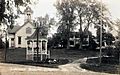
Town center c. 1915
-
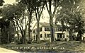
Elm Street c. 1915
-
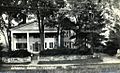
Weddell House c. 1915
-
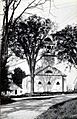
Cong. Church c. 1915


See also
 In Spanish: Limerick (Maine) para niños
