
Effingham, New Hampshire facts for kids
Quick facts for kids
Effingham, New Hampshire
|
|
|---|---|
|
Town
|
|

Lord's Hill Historic District, one of the village centers of Effingham
|
|

Location in Carroll County, New Hampshire
|
|
| Country | United States |
| State | New Hampshire |
| County | Carroll |
| Incorporated | 1778 |
| Villages |
|
| Area | |
| • Total | 39.9 sq mi (103.4 km2) |
| • Land | 38.8 sq mi (100.4 km2) |
| • Water | 1.2 sq mi (3.0 km2) 2.87% |
| Elevation | 597 ft (182 m) |
| Population
(2020)
|
|
| • Total | 1,691 |
| • Density | 44/sq mi (16.8/km2) |
| Time zone | UTC−5 (Eastern) |
| • Summer (DST) | UTC−4 (Eastern) |
| ZIP Codes |
03882 (Effingham)
03864 (Ossipee) |
| Area code(s) | 603 |
| FIPS code | 33-23620 |
| GNIS feature ID | 0873588 |
Effingham is a small town in Carroll County, New Hampshire, United States. It is located in the beautiful New England region. In 2020, about 1,691 people lived there. This was an increase from 1,465 people in 2010.
Effingham is made up of several smaller communities. These include Effingham Falls, Effingham (also known as Lord's Hill), Center Effingham (Drake's Corner), and South Effingham. A part of the Pine River State Forest is also found in the southern area of the town.
Contents
History of Effingham
The town of Effingham was first settled by members of the Leavitt family. They came from Hampton, New Hampshire. The leader of this group was Captain John Leavitt. Because of them, the settlement was first called "Leavitt's Town."
In 1749, the land was officially given to the settlers by Governor Benning Wentworth. He decided to rename it "Effingham." This new name honored the Howard family, who were Earls of Effingham. They were related to the Wentworth family through marriage. The town officially became a town (or "incorporated") in 1778.
In 1831, the northern part of Effingham became its own town. It was named Freedom. By 1859, Effingham had a population of 1,252 people. At that time, Effingham Falls had grown into a busy small town with factories. These factories included a woolen factory, five sawmills, three gristmills (for grinding grain), and a carriage factory.
Effingham is also famous for something special. It was home to the first "normal school" in New Hampshire. A normal school was a place that trained teachers. This school started in 1830. It was on the second floor of the Effingham Union Academy building, which was built in 1819. A man named James W. Bradbury led the school. He later became a U.S. senator for Maine. He insisted that the school should be only for "instruction and training of teachers." This idea was very new at the time.
Geography and Nature
Effingham covers a total area of about 103.4 square kilometers (about 40 square miles). Most of this area, about 100.4 square kilometers (38.8 square miles), is land. The rest, about 3.0 square kilometers (1.2 square miles), is water. Water makes up about 2.87% of the town's total area.
The highest point in Effingham is Green Mountain. It stands tall at about 574 meters (1,884 feet) high. The town gets its water from the Ossipee River and its smaller rivers. These include the Pine River and the South River.
Part of Province Lake is in the southern part of Effingham. Also, small parts of Ossipee Lake (like Broad Bay and Berry Bay) are in the north. The eastern border of Effingham is the state line with Maine. The Ossipee River forms the northern border.
Effingham is part of the Saco River watershed. This means that all the water in Effingham eventually flows into the Saco River. The Ossipee River area, which is partly in Effingham, has the largest underground water supply (called an aquifer) in New Hampshire. Much of Effingham's land helps to refill this important underground water source.
The town is connected by two main state roads: Route 25 and Route 153.
Neighboring Towns
- Freedom (to the north)
- Parsonsfield, Maine (to the east)
- Wakefield (to the southeast)
- Ossipee (to the west)
Population Information
| Historical population | |||
|---|---|---|---|
| Census | Pop. | %± | |
| 1790 | 154 | — | |
| 1800 | 451 | 192.9% | |
| 1810 | 876 | 94.2% | |
| 1820 | 1,368 | 56.2% | |
| 1830 | 1,911 | 39.7% | |
| 1840 | 1,195 | −37.5% | |
| 1850 | 1,252 | 4.8% | |
| 1860 | 1,209 | −3.4% | |
| 1870 | 904 | −25.2% | |
| 1880 | 865 | −4.3% | |
| 1890 | 720 | −16.8% | |
| 1900 | 600 | −16.7% | |
| 1910 | 558 | −7.0% | |
| 1920 | 393 | −29.6% | |
| 1930 | 352 | −10.4% | |
| 1940 | 377 | 7.1% | |
| 1950 | 341 | −9.5% | |
| 1960 | 329 | −3.5% | |
| 1970 | 360 | 9.4% | |
| 1980 | 599 | 66.4% | |
| 1990 | 941 | 57.1% | |
| 2000 | 1,273 | 35.3% | |
| 2010 | 1,465 | 15.1% | |
| 2020 | 1,691 | 15.4% | |
| U.S. Decennial Census | |||
In 2000, there were 1,273 people living in Effingham. There were 490 households, and 336 of these were families. The population density was about 13 people per square kilometer (33 people per square mile).
About 29% of households had children under 18 years old. Around 53.5% of households were married couples living together. The average household had 2.43 people, and the average family had 2.88 people.
The population was spread out by age. About 26% of the people were under 18. About 12.6% were 65 years old or older. The average age in town was 38 years.
Famous People from Effingham
- David Burbank (1821 – 1895), a dentist and real estate investor. He was born in Effingham. He is famous for founding and naming the city of Burbank, California.
Images for kids
-
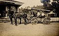
Post Office in 1908
-
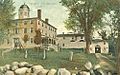
Lord Mansion in 1908
-
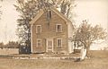
Normal School in 1910
-
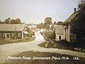
Effingham Falls in 1915


See also
 In Spanish: Effingham (Nuevo Hampshire) para niños
